Samoa State Marine Conservation Area

shorebirds on a foggy day at the beach

Overview

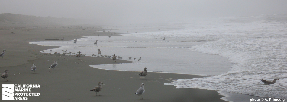
Located about three miles west of Arcata, Samoa State Marine Conservation Area (SMCA) sits in the middle of Humboldt County's coastline. Protecting more than 13 square miles, this SMCA hugs the northern end of the Samoa peninsula, a spit that separates Humboldt and Arcata bays from the Pacific Ocean. Together, these bays form the second largest estuary in California. This marine protected area (MPA) features more than four miles of shoreline, with coastal dunes and grasses rolling behind the sandy shore.

The MPA extends from its sandy beaches to depths of over 150 feet, cascading to soft, muddy and sandy seafloor lined with eelgrass and sea whips. The marine habitat supports a large variety of fishes like rockfish, lingcod, and surfperch. Anadromous fish such as Chinook salmon pass through Samoa SMCA during lifecycle migrations, heading to nearby Mad River to spawn as adults, while young fish newly acclimated to salt water exit from the river to grow to adulthood in ocean waters. Dungeness crab can be taken inside the SMCA. Those who wish to remain onshore can relish the tranquility of the solitary beach while enjoying the superb beachcombing and wildlife viewing opportunities that Samoa SMCA offers.

Regulations

It is unlawful to injure, damage, take, or possess any living, geological, or cultural marine resource, EXCEPT:
Recreational take of salmon by trolling, surf smelt by dip net or Hawaiian-type throw net, and Dungeness crab by trap, hoop net or hand is allowed. Commercial take of salmon with troll fishing gear, surf smelt by dip net, and Dungeness crab by trap is allowed. Includes take exemptions for the following tribe:

  • Wiyot Tribe

California Code of Regulations Title 14, Section 632(b)(8)(opens in new tab)

Quick Facts

MPA size: 13.06 square miles

Shoreline span: 3.6 miles

Depth range: 0 to 158 feet

Habitat composition*:

  • Sand/mud: 13.01 square miles

*Habitat calculations are based on 3-dimensional area and may exceed the total MPA area listed above.

Photo Gallery

2 OCT
2023

Pacific sand crab molts washed ashore at Samoa SMCA

0

photo © northcoastmpas, CC BY-NC 2.0

Showing 0 Comment

Video Gallery

California's MPA Network

About Samoa State Marine Conservation Area

Natural History

small, long-legged bird in the surf
Black-bellied plovers are one of the many species that use the habitats in Samoa SMCA. photo © J. Reiss, CC BY-NC 2.0

While beachcombing along the waves of Samoa SMCA, you may come across eelgrass, sand dollars, or Pacific razor clam shells. This area is also the feeding and nesting area for shorebirds such as the western snowy plover. Snowy plovers nest along the shore from March through September, so visitors should take special care not to disturb this threatened species during breeding season.

The deep-water seafloor is lined with soft sand and mud, providing habitat for sea whips, sea pens, and white-plumed anemones that sway in the current, while surfperch and surf smelt swim above. The California current brings cold water south from Alaska to the Humboldt area, and the wind draws this nutrient-rich water to the surface just offshore. This phenomenon, called upwelling, is important in supporting various populations of sea life such as lingcod, cabezon, and California halibut, all of which proliferate in the nutrient-rich waters of Samoa SMCA.

Just a couple of miles north, Mad River enters the Pacific Ocean next to the town of McKinleyville, after flowing nearly 113 miles past the communities of Ruth and Mad River. There is a close relationship between Mad River and many of the species found in Samoa SMCA. Coho salmon, Chinook salmon, and steelhead pass through the MPA on their way to the river mouth. The shallow Mad River estuary serves as a nursery for juvenile salmon, trout, rockfish, and flatfish such as English sole. Species such as surf smelt also use the estuary as a summer feeding ground as the seagrasses slow the moving water, allowing food particles to settle to the bottom. These species are abundant in Samoa SMCA due to its proximity to the Mad River estuary.

Cultural History

grass and low lying plants with pink tufts on seaside dunes
The Wiyot have a long-standing history within Samoa SMCA. photo © A. Bairstow, CC BY-NC 2.0

For centuries, Native American Tribes in California have relied on marine and coastal resources. Many Native American Tribes in California continue to regularly harvest marine resources within their ancestral territories and maintain relationships with the coast for ongoing customary uses.

Wiyot people have lived in the Wigki (Humboldt Bay) region for thousands of years. The Wiyot foraged shellfish and razor clams from the beach, smelt from the surf, mussels from large driftwood logs, and clams from the mudflats. There were several Wiyot villages near present day Samoa SMCA, including villages and surf fishing camps on South Spit and among the Lanphere and Ma-le'l coastal dunes. Through a factual record of historical take within the Samoa SMCA, the Wiyot Tribe is exempt from SMCA regulations.

Humboldt Bay escaped the eye of many ocean explorers during the European exploration of the eastern Pacific between the 1500s and 1700s. The first documented visit to the area occurred in the early 1800s by a sea otter hunting expedition known as O’Cain. Interest in the area grew in the 1850s as settlers arrived by ship in search of timber and gold. The town of Samoa on the northern peninsula of Humboldt Bay is the site of Samoa Cookhouse, one of the last remaining original, lumberjack-style cookhouses in the area. Today, around 18,000 people live in Arcata, the closest city to Samoa SMCA.

Recreation

hiker walks barefoot on broad sandy beach at low tide
The secluded Samoa SMCA offers a tranquil respite to visitors. photo © K. Nielson, CC BY NC-SA 4.0

Samoa SMCA offers visitors a secluded beach with ample recreational activities. The beach, coastal dunes, and grasses behind the wave slope offer a peaceful backdrop for long walks. The tranquility of this MPA makes it an ideal spot for beachcombing, wildlife viewing, and birdwatching. Birdwatchers may spot sandpipers scurrying along the water's edge, and pelicans and cormorants soaring overhead.

There are also trails along the southern end of Samoa SMCA in the Lanphere and Ma-le'l Dunes where a local organization, Friends of the Dunes, offers guided walks. Just to the south, Samoa Beach is a beach break popular for surfing. Along the northern edge of Samoa SMCA, Mad River County Park is one of the best picnic beaches along the Humboldt coast. The park offers parking, restrooms, camping, and hiking opportunities. Recreational take of salmon by trolling, surf smelt by dip net or Hawaiian-type throw net, and Dungeness crab by trap, hoop net or hand is allowed.


Coordinates

This area is bounded by the mean high tide line and straight lines connecting the following points in the order listed except where noted:

40° 55.000' N. lat. 124° 08.432' W. long.;
40° 55.000' N. lat. 124° 12.677' W. long.; thence southward along the three nautical mile offshore boundary to
40° 52.000' N. lat. 124° 14.225' W. long.; and
40° 52.000' N. lat. 124° 09.803' W. long.

California Code of Regulations Title 14, Section 632(b)(8)

Downloads for Samoa State Marine Conservation Area

Map

Map of Samoa State Marine Conservation Area - click to enlarge in new tab

Facts, Map & Regulations

MPA fact sheet - click to enlarge in new tab