Russian River State Marine Conservation Area/State Marine Recreational Management Area

rocky ocean shoreline

Overview

Russian River State Marine Conservation Area (SMCA) and Russian River State Marine Recreational Management Area (SMRMA) are connected marine managed areas lying at the mouth of the Russian River in Sonoma County, 50 miles northwest of San Francisco. The Russian River empties fresh water into the Pacific Ocean at the juncture of these marine managed areas. The SMCA protects less than one square mile extending offshore from the mouth of the river to depths of around 60 feet, and the SMRMA protects less than a half square mile extending from the beach at the mouth of the river inland to the brackish waters at the bridge of Highway 1.

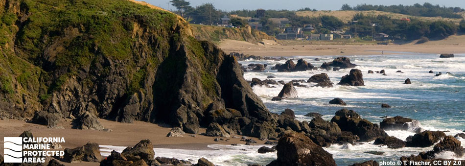
The nearshore and estuarine ecosystems protected within Russian River SMCA and SMRMA are rare along this stretch of the California coast and support several unique habitats and a rich biodiversity. The sandy beaches, rocky shores, submerged reef, and kelp forests of the SMCA protect salmonids like steelhead trout and coho and Chinook salmon, which return to the Russian River to reproduce. Gray whales are frequently spotted cruising by during their migration to and from Baja Mexico, and harbor seals and sea lions hauled out on the sandbar at the river mouth can be heard barking over the crash of the waves.

The coastal marsh and estuary of the SMRMA also protect salmonids, which aggregate at the mouth of the estuary during seasonal sandbar closures. Surfperch, American shad, and bay pipefish, as well as river otters and wetland birds use this ocean-river corridor for critical life history stages. Birdwatching, surfing, kayaking, and hiking can be enjoyed in the area, a popular destination for those who seek to witness the meeting of river and sea.

Regulations

Russian River SMCA

It is unlawful to injure, damage, take, or possess any living, geological, or cultural marine resource, EXCEPT:

Recreational and commercial take of Dungeness crab by trap is allowed. Recreational take of surf smelt by hand-held dip net or beach net is allowed.

California Code of Regulations Title 14, Section 632(b)(38)(opens in new tab)

Russian River SMRMA

It is unlawful to injure, damage, take, or possess any living, geological, or cultural marine resource, EXCEPT:

Take of waterfowl in accordance with general waterfowl regulations is allowed.

California Code of Regulations Title 14, Section 632(b)(37)(opens in new tab)

Quick Facts

Russian River SMCA

MPA size: 0.84 square miles

Shoreline span: 1.4 miles

Depth range: 0 to 57 feet

Habitat composition*:

  • Rock: 0.69 square miles
  • Sand/mud: 0.57 square miles

Russian River SMRMA

SMRMA size: 0.36 square miles

Shoreline span: 1.44 miles

Depth range: 0 to 10 feet

Habitat composition*:

  • Estuary: 0.02 square miles
  • Coastal marsh: 0.78 square miles

*Habitat calculations are based on 3-dimensional area and may exceed the total MPA area listed above.

Photo Gallery

20 OCT
2022

Brown pelicans and Heermann's gulls in Russian River SMRMA

0

photo © M. Witkowski, CC BY-NC 2.0

Showing 0 Comment

Video Gallery

California's MPA Network

About Russian River State Marine Conservation Area/State Marine Recreational Management Area

Natural History

a duck flying over the ocean
Common goldeneye in Russian River SMRMA. photo © S. J. Davies, CC BY-NC 2.0

The Russian River watershed lies in a highly erodible area. Landslides are common here, both above and below the ocean surface. Over thousands of years, this erodible geology, in combination with heavy winter rains, created the large estuarine system at the mouth of the Russian River. The two marine managed areas protect not only the estuary itself, but also an area of shifting sandbars and deep channels on the seaward side. The estuary at the mouth of the Russian River is often closed off from the open ocean by a sandbar due to low river flows and shifting sand. When the sandbar develops, the protected sandy beach offers resting spots for harbor seals and seabirds. The sandbar can be breached throughout the year by rough ocean conditions or rainstorm events to connect the estuary directly to the sea, especially during the winter.

The marshy and sandy SMRMA supports resident and migrating birds such as snowy egrets, western grebes, mallard and wood ducks, and common mergansers. The shallow marsh is teeming with both brackish-water and saltwater fish, many of which use the wetland as critical nursery habitat. Crabs, shrimp, and surfperch can be found sheltering in the wetland’s submerged vegetation.

The two Russian River marine managed areas were created as an additional level of protection for anadromous fish, such as steelhead trout and salmon. Historically, the Russian River supported abundant steelhead trout, coho salmon, and Chinook salmon. Their populations crashed due to habitat alteration, dam construction, and the resulting loss of spawning habitat. In 2001, only four coho salmon returned to the river to spawn. This catalyzed the community into action, and salmon were reintroduced using local hatchery fish. In 2011, 190 adult coho salmon returned to the watershed.

Cultural History

reddish abalone on an algae covered rock
Red abalone in Russian River SMCA. photo © Brock, CC BY-NC 2.0

For centuries, Native American Tribes in California have relied on marine and coastal resources. Many Native American Tribes in California continue to regularly harvest marine resources within their ancestral territories and maintain relationships with the coast for ongoing customary uses. The Southern Pomo called the Russian River Ashokawna, or the "water to the east", and Bidapte, "big river".

Juan Rodriguez Cabrillo and his expedition were likely the first Europeans to reach the area in 1542, but storms forced them to turn south. The river is named for Ivan Kuskov, a Russian explorer who established the Fort Ross colony to the north. They called it the Slavyanka River, and hunted and traded beaver and otters from Fort Ross. The redwoods that lined the river banks drew loggers during the 1800s, and these small riverside communities grew into what are now Jenner, Guerneville, and Healdsburg.


Recreation

ocean waves break on a rocky beach below a worn hillside
Goat Rock State Beach in Russian River SMCA. photo © A. J. A. Crispin, CC BY-NC 2.0

The Russian River marine managed areas offer visitors many ways to explore the freshwater river and large estuary. The estuary is typically blocked from ocean waves, providing calm conditions for kayakers to enjoy the many wildlife viewing opportunities. Birdwatching is immensely popular, with regular sightings of common loons, great blue herons, snowy egrets, and double-crested cormorants. Surfers may want to try their luck catching waves at the river mouth, but please note the conditions are usually challenging and not suited for beginners.

At the adjacent Sonoma Coast State Park, visitors can explore the estuary shores and large sandbars at Goat Rock Beach. Harbor seals frequently haul out on the sandbar, drawing crowds on the bluffs of Highway 1 above for easy viewing. A keen eye may also spot northern elephant seals and northern fur seals since these large pinnipeds often rest on the remote beaches in this area.

Fishermen are welcome to try catching Dungeness crab by trap within the SMCA, and recreational fishermen can also try to capture surf smelt with a hand-held dip net or beach net, but no other take is permitted within the Russian River SMCA. Within the Russian River SMRMA, waterfowl hunting is allowed in accordance with regulations, but no other take is permitted.

Coordinates

Russian River SMCA

This area is bounded by the mean high tide line, the mouth of the Russian River estuary as defined in subsection 632(b)(37)(A), and straight lines connecting the following points in the order listed:

38° 27.380′ N. lat. 123° 08.580′ W. long.;
38° 26.380′ N. lat. 123° 08.580′ W. long.;
38° 26.380′ N. lat. 123° 07.700′ W. long.

California Code of Regulations Title 14, Section 632(b)(38)

Russian River SMRMA

This area includes the waters below the mean high tide line eastward of the mouth of the Russian River estuary defined as a line connecting the following two points:

38° 27.160′ N. lat. 123° 07.910′ W. long.;
38° 27.010′ N. lat. 123° 07.740′ W. long.
and westward of the Highway 1 Bridge.

California Code of Regulations Title 14, Section 632(b)(37)

Downloads for Russian River State Marine Conservation Area

Map

Map of Russian River State Marine Conservation Area - click to enlarge in new tab

Facts, Map & Regulations

MPA fact sheet - click to enlarge in new tab

Downloads for Russian River State Marine Recreational Management Area

Map

Map of Russian River State Marine Recreational Management Area - click to enlarge in new tab

Facts, Map & Regulations

MPA fact sheet - click to enlarge in new tab