Point Vicente State Marine Conservation Area (No-Take), and Abalone Cove State Marine Conservation Area

houses atop seaside bluffs, waves crashing below

Overview

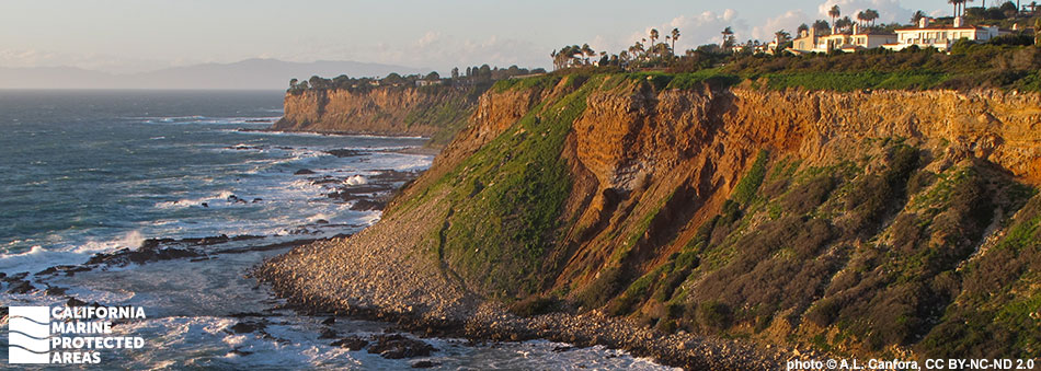
Point Vicente State Marine Conservation Area (SMCA) (No-Take) and Abalone Cove State Marine Conservation Area (SMCA) are adjacent marine protected areas (MPAs) located along the coast of Palos Verdes, roughly 20 miles south of Santa Monica and the greater Los Angeles area. Spanning nearly three miles of coastline, the coves, beaches, bluffs, and coastal trails in and around these MPAs provide many opportunities for recreation including spending time at the beach, hiking, surfing, diving, and whale watching.

Point Vicente SMCA (No-Take), together with the adjacent Abalone Cove SMCA form an almost 20 square mile contiguous protection zone. Point Vicente SMCA (No-Take) encompasses more than 15 square miles of kelp forests, sandy beaches, rocky reefs, hard and soft seafloor habitats that reach depths greater than 2,600 feet, and rocky intertidal areas. Many species thrive in these MPAs, including garibaldi, California sheephead, and California spiny lobster.

Abalone Cove SMCA encompasses nearly five square miles of rocky shoreline, sandy beaches, surfgrass beds, kelp forests, and sandy and rocky seafloor habitats that reach depths greater than 2,200 feet. The MPA's quiet tidepools protect California spiny lobsters, sea urchins, and other rocky tidepool inhabitants, while providing structure for surfgrass beds. The Palos Verdes Peninsula juts out to sea close to a deepwater offshore basin, making Point Vicente SMCA (No-Take) and Abalone Cove SMCA a mix of nearshore and offshore ecosystems.

Regulations

Point Vicente SMCA (No-Take)

It is unlawful to injure, damage, take, or possess any living, geological, or cultural marine resource. Take incidental to certain permitted activities may be allowed. Other restrictions may apply. See CCR T14 §632(b) (link below) for details.

California Code of Regulations Title 14, Section 632(b)(119)(opens in new tab)

Abalone Cove SMCA

It is unlawful to injure, damage, take, or possess any living, geological, or cultural marine resource, EXCEPT:

Recreational take of market squid by hand-held dip net, and white seabass and pelagic finfish (northern anchovy, barracudas, billfishes, dorado (dolphinfish), Pacific herring, jack mackerel, Pacific mackerel, Pacific sardine, blue shark, salmon shark, shortfin mako shark, thresher shark, swordfish, tunas, Pacific bonito, and yellowtail) by spearfishing is allowed.

Commercial take of coastal pelagic species (northern anchovy, Pacific sardine, Pacific mackerel, jack mackerel, and market squid) by round-haul net, brail gear, and light boat is allowed. Not more than five percent by weight of any commercial coastal pelagic species catch landed or possessed shall be other incidentally taken species. Commercial take of swordfish by harpoon is allowed.

California Code of Regulations Title 14, Section 632(b)(120)(opens in new tab)

Quick Facts

Point Vicente SMCA (No-Take)

MPA size: 15.04 square miles

Shoreline span: 1.40 miles

Depth range: 0 to 2,640 feet

Habitat composition*:

  • Sand/mud: 14.76 square miles
  • Rock: 0.68 square miles

Abalone Cove SMCA

MPA size: 4.79 square miles

Shoreline span: 1.5 miles

Depth range: 0 to 2,237 feet

Habitat composition*:

  • Sand/mud: 4.53 square miles
  • Rock: 0.51 square miles

*Habitat calculations are based on 3-dimensional area and may exceed the total MPA area listed above.

Photo Gallery

12 OCT
2023

Brown pelicans soar over Pt. Vicente SMCA and Abalone Cove SMCA

0

photo © cdavis aop, CC BY-NC 2.0

Showing 0 Comment

Video Gallery

Southern California Marine Protected Area Highlights

California's MPA Network

About Point Vicente State Marine Conservation Area (No-Take), and Abalone Cove State Marine Conservation Area

Natural History

a juvenile sea lion rests on a rock, brown sleek fur reflects golden light of sunset, its flippers point horizontally with its head held high, warming itself
California sea lion at Abalone Cove SMCA. photo © W. Mason, CC BY-NC 2.0

These two MPAs are geologically part of the Palos Verdes Peninsula, a large, rugged point made of Altamira shale that has been uplifted over millions of years due to local tectonic activity. The shale created an erosion-resistant shoreline with rocky reefs, coves, and kelp forests close to shore. Just offshore lies a large shelf, or underwater cliff, and deep sandy seafloor.

As a rocky headland, Point Vicente SMCA (No-Take) is a diverse and productive area with deep water near shore, healthy kelp forests, and complex physical landforms. Offshore, sandy seafloor provides habitat for flatfishes including sole, halibut, and flounder, while rocky seafloor anchors kelp forests that thrive and provide refuge for rockfish, California sheephead, kelp bass, lingcod, and painted greenling.

Invertebrates like sea cucumbers, spot prawn, ridgeback prawn, crabs, and California spiny lobster move freely beneath the ocean surface, while immobile invertebrates like mussels, scallops, and barnacles cling to the rocks. Larger marine animals are also common to the area, with thousands of gray whales spotted each winter from Point Vicente. Dolphins, harbor seals, and sea lions may be spotted year-round, and divers may see occasional giant sea bass.

Cultural History

an abalone in the a tidepool of algae-coated rocks
Green abalone in Abalone Cove SMCA. photo © Z. Allen, CC BY-NC 2.0

For centuries, Native American Tribes in California have relied on marine and coastal resources. Many Native American Tribes in California continue to regularly harvest marine resources within their ancestral territories and maintain relationships with the coast for ongoing customary uses. Point Vicente is a part of the Rancho Palos Verdes area, which dates back to the Gabrielino (Tongva) people who have inhabited the land for thousands of years. The Tongva used the local resources for food, trade, and building supplies. The traditional Tongva diet consists of halibut, lobster, sea bass, and intertidal organisms. The abundant natural tar and oil seeps were used as sealants for sturdy, ocean-going canoes employed in fishing and trading.

The first documented European activity dates back to 1542 when Spanish explorer Juan Rodriguez Cabrillo navigated the coastline. Rancho Palos Verdes was established by a Mexican land grant in 1846 and given to Juan Capistrano Sepulveda. The point itself was later named Point Vicente by Captain George Vancouver who named it after his friend Friar Vicente of the Mission Buenaventura. Ranching became the primary use of the area, with the land remaining largely unoccupied until commercial and residential development began in the early 1900s.

One of the biggest additions to this stretch of coast occurred in 1926 when the Point Vicente Lighthouse was erected to keep ships safe from this challenging stretch of coast. In 1929, the Portuguese Bend landslide occurred at the southern point of San Pedro, near Abalone Cove, moving 40,000 feet of land into the Pacific Ocean and earning the area the name Sunken City. Despite growth and construction in the early 1900s, much of the land and coastline along the Palos Verdes Peninsula remains undeveloped, a rare occurrence in the greater Los Angeles area.

Recreation

lighthouse on a bluff above the sea at sunset
Point Vicente Lighthouse near Point Vicente SMCA (No-Take). photo © C. F. Bagge, CC BY-NC 2.0

Point Vicente SMCA (No-Take) and Abalone Cove SMCA are unique protected areas in a heavily developed region of the state. The protection afforded by these MPAs has created an area well-suited for beachgoers, whale watchers, surfers, and scuba and free divers. Divers may even catch a glimpse of a giant sea bass, California’s largest nearshore bony fish that can reach more than eight feet in length and weigh more than 500 pounds.

Point Vicente SMCA (No-Take) is a No-Take SMCA that prohibits all recreational and commercial fishing, while Abalone Cove SMCA allows recreational take of white seabass and pelagic finfish by spear and market squid by hand-held dip net. The Point Vicente Interpretive Center is located on the bluffs overlooking the MPAs next to the Point Vicente Lighthouse. The Center offers information and activities to visitors and is a popular location to watch for whales. Coastal access and parking can be found at the Point Vicente Interpretive Center, Pelican Cove, Terranea Resort, and Abalone Cove Shoreline Park.

Coordinates

Point Vicente SMCA (No-Take)

This area is bounded by the mean high tide line and straight lines connecting the following points in the order listed except where noted:

33° 44.800′ N. lat. 118° 24.807′ W. long.;
33° 44.800′ N. lat. 118° 28.931′ W. long.; thence southeastward along the three nautical mile offshore boundary to
33° 41.155′ N. lat. 118° 23.800′ W. long.; and
33° 44.198′ N. lat. 118° 23.800′ W. long.

California Code of Regulations Title 14, Section 632(b)(119)

Abalone Cove SMCA

This area is bounded by the mean high tide line and straight lines connecting the following points in the order listed except where noted:

33° 44.198′ N. lat. 118° 23.800′ W. long.;
33° 41.155′ N. lat. 118° 23.800′ W. long.; thence southeastward along the three nautical mile offshore boundary to
33° 40.851′ N. lat. 118° 22.500′ W. long.; and
33° 44.240′ N. lat. 118° 22.500′ W. long.

California Code of Regulations Title 14, Section 632(b)(120)

Downloads for Point Vicente SMCA (No-Take)

Map

Map of Point Vicente SMCA (No-Take) State Marine Reserve - click to enlarge in new tab

Facts, Map & Regulations

MPA fact sheet - click to enlarge in new tab

Downloads for Abalone Cove SMCA

Map

Map of Abalone Cove State Marine Conservation Area - click to enlarge in new tab

Facts, Map & Regulations

MPA fact sheet - click to enlarge in new tab