Point Sur State Marine Reserve/State Marine Conservation Area

large plateaus extend out into the ocean forming a crescent shaped beach

Overview

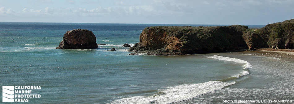
Point Sur State Marine Reserve (SMR) and Point Sur State Marine Conservation Area (SMCA) are located 25 miles south of Monterey in Big Sur, along California’s Central Coast. The SMR spans more than five miles of shoreline from Point Sur to Cooper Point at the southern end of Andrew Molera State Park. Taken together, the two marine protected areas (MPAs) encompass approximately 20 square miles of sandy seafloor, tidal flats, surfgrass, and rocky pinnacles, as well as the shallowest portions of Sur Canyon, a submarine canyon that reaches depths greater than 600 feet within the SMCA.

The diverse topography creates niches for marine invertebrates like mussels, crabs, anemones, limpets, and sea stars. Caverns, outcroppings, and overhangs created by the complex rocky reef provide habitat for innumerable fish and invertebrates. Rockfish, sculpin, bat rays, cabezon and lingcod thrive in the nearshore kelp forests. Marine mammals like sea otters and harbor seals seek shelter near shore and often go ashore to rest. In deeper waters, salmon and albacore migrate along the coast. The shoreline is accessible near Andrew Molera State Park, and the SMR is also easily viewed from turnouts along Highway 1.

Regulations

Point Sur SMR

It is unlawful to injure, damage, take, or possess any living, geological, or cultural marine resource.

California Code of Regulations Title 14, Section 632(b)(83)(opens in new tab)

Point Sur SMCA

It is unlawful to injure, damage, take, or possess any living, geological, or cultural marine resource, EXCEPT:

Recreational and commercial take of salmon and albacore is allowed.

California Code of Regulations Title 14, Section 632(b)(84)(opens in new tab)

Quick Facts

Point Sur SMR

MPA size: 9.79 square miles

Shoreline span: 5.5 miles

Depth range: 0 to 183 feet

Habitat composition*:

  • Rock: 7.89 square miles
  • Sand/mud: 6.13 square miles

Point Sur SMCA

MPA size: 10.62 square miles

Depth range: 139 to 624 feet

Habitat composition*:

  • Sand/mud: 9.81 square miles
  • Rock: 0.81 square miles

*Habitat calculations are based on 3-dimensional area and may exceed the total MPA area listed above.

Photo Gallery

10 OCT
2022

Brown pelicans and western gulls in Point Sur SMR

0

photo © J. W. F. Chu, CC BY-NC 2.0

Showing 0 Comment

Video Gallery

California's MPA Network

About Point Sur State Marine Reserve/State Marine Conservation Area

Natural History

coral and gorgonian
Purple gorgonian in Point Sur SMCA. CDFW/MARE photo

Point Sur is a site of unique geologic features. Modern sediment plains are interrupted by outcrops of rocky Franciscan Formation to create diverse habitats along the shoreline and under the surface. On shore, rocky headlands, sandy beaches and dunes are backed by ancient marine terraces. Nearshore rocks provide refuge for nesting western gulls, Brandt's and pelagic cormorants, pigeon guillemots, ashy storm-petrel, Cassin's auklet, tufted puffin, and other birds migrating along the Pacific Flyway.

Point Sur SMCA is composed of mostly sandy habitat with the occasional rocky outcropping. It is home to a wide range of fish and invertebrate species. Sur Canyon, an offshoot of the larger Monterey Submarine Canyon, lies just eight miles south of Point Sur and reaches a maximum depth of 3,000 feet outside of the SMCA. Upwelling, a process in which cold, nutrient-rich water rises from deeper waters to the surface, defines this coastline, creating conditions for a diverse array of plant and animal life.

Beneath the surface, kelp forests teem with different fish species including cabezon, vermilion rockfish, and blue rockfish. Sea otters, sea lions, and harbor seals feed and rest in nearshore waters, while gray, humpback, and blue whales migrate past Point Sur from November to May. The two MPAs were designed to protect this hotspot of rich marine biodiversity, while minimizing effects to nearby rockfish fisheries.

Cultural History

deep blue ocean water surrounds a spit of sand with a large rocky green plateau at the tip
Looking southwest from the northern boundary of Point Sur SMR. photo © S. Rae, CC BY-NC 2.0

For centuries, Native American Tribes in California have relied on marine and coastal resources. Many Native American Tribes in California continue to regularly harvest marine resources within their ancestral territories and maintain relationships with the coast for ongoing customary uses. The Ohlone, Esselen, and Salinan people historically lived along this stretch of coastline, leading a nomadic, hunter-gatherer existence for thousands of years. They took advantage of the abundance of marine life, harvesting rich stocks of mussels, abalone, and fish.

The Portuguese explorer Juan Cabrillo was the first European to mention Point Sur in 1542. Later in 1602, the Spanish explorer Sebastian Vizcaino labeled Point Sur on his map as “point that appears as a small island.” In the early 1800s, El Sur Rancho was created through a land grant by the Governor of Mexican California. Many ranchers leased parcels surrounding Point Sur to graze cattle; sections are still used for ranching today.

The offshore rocks surrounding Point Sur, notoriously difficult to navigate, led to numerous shipwrecks and eventually to the construction of the Point Sur Lighthouse, which was first lit in 1889. The lighthouse sits atop a rocky point more than 300 feet above the Pacific Ocean. Another point of historical interest is Point Sur Naval Facility, a top-secret Cold War-era submarine surveillance facility built in 1958 by the U.S. Navy. The facility was connected to undersea hydrophones, used to listen for enemy submarine activity. During surveillance, the public was led to believe it was an oceanographic research station. The facility closed in 1984, and in 2000 most of the naval facilities were donated to California State Parks. Today, the land is home to Point Sur State Historic Park, and docents offer guided tours of the naval facility and light station.

Recreation

a stone lighthouse with a red rounded roof sits on a cliffside
Point Sur Lighthouse at Point Sur SMR. photo © R. Schwemmer/NOAA

Point Sur SMR is directly accessible from a trail that follows Big Sur River at Andrew Molera State Park. Alternatively, you can see the MPAs from one of the many turnouts that are located along Highway 1. Views offer incredible wildlife watching opportunities. Bring your binoculars and watch for migrating birds and marine mammals.

Point Sur can only be accessed by guided tours with Point Sur State Historic Park. Schedule a guided tour to visit the Point Sur Lighthouse or Point Sur Naval Facility, or travel farther south to Andrew Molera State Park to enjoy hiking trails, beach access, and camping. While no take is allowed within the SMR, within the SMCA salmon and albacore may be taken.

Coordinates

Point Sur SMR

This area is bounded by the mean high tide line and straight lines connecting the following points in the order listed:

36° 18.400′ N. lat. 121° 54.150′ W. long.;
36° 18.400′ N. lat. 121° 56.000′ W. long.;
36° 15.000′ N. lat. 121° 52.500′ W. long.; and
36° 15.000′ N. lat. 121° 50.250′ W. long.

California Code of Regulations Title 14, Section 632(b)(83)

Point Sur SMCA

This area is bounded by straight lines connecting the following points in the order listed except where noted:

36° 18.400′ N. lat. 121° 56.000′ W. long.;
36° 18.400′ N. lat. 121° 57.932′ W. long.; thence southward along the three nautical mile offshore boundary to
36° 15.000′ N. lat. 121° 55.955′ W. long.;
36° 15.000′ N. lat. 121° 52.500′ W. long.; and
36° 18.400′ N. lat. 121° 56.000′ W. long.

California Code of Regulations Title 14, Section 632(b)(84)

Downloads for Point Sur State Marine Reserve

Map

Map of Point Sur State Marine Reserve - click to enlarge in new tab

Facts, Map & Regulations

MPA fact sheet - click to enlarge in new tab

Downloads for Point Sur State Marine Conservation Area

Map

Map of Point Sur State Marine Conservation Area - click to enlarge in new tab

Facts, Map & Regulations

MPA fact sheet - click to enlarge in new tab