Point Lobos State Marine Reserve/State Marine Conservation Area

rounded rocks extend up from deep blue waters, kelp patties dot the ocean, crescent shaped coastline extends out along the horizon terminating at a thin strip land

Overview

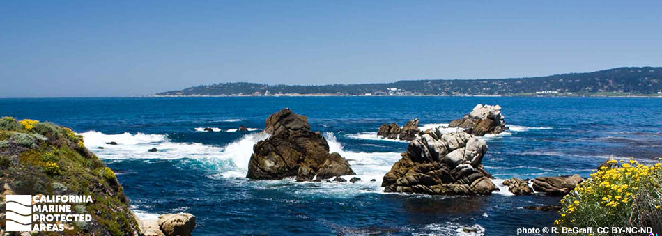
Point Lobos State Marine Reserve (SMR) and Point Lobos State Marine Conservation Area (SMCA) are a pair of marine protected areas (MPAs) that safeguard the fascinating underwater terrain and spectacular marine life adjacent to Point Lobos State Natural Reserve on shore. Located south of Monterey Bay, these MPAs together encompass almost 14 square miles of habitat from shore to depths of around 1,800 feet.

A portion of the Point Lobos SMR has been protected since 1963, which makes it one of the oldest MPAs in California. Point Lobos SMR offers a glimpse of what younger SMRs may look like in the future. This 5½ square mile SMR includes a small sliver of the Carmel Submarine Canyon, sandy seafloor, extensive rock formations, surfgrass beds, and kelp forests that are home and hunting grounds to an abundance of large, mature fishes such as lingcod and blue rockfish, and invertebrates including sponges, gorgonians, and colorful nudibranchs (sea slugs). Seaward of the SMR, the nearly 8½ square mile SMCA protects sandy seafloor habitat, rocky reefs, and about one-third of a square mile of the Carmel Submarine Canyon.

With their unparalleled species abundance and biodiversity, these MPAs offer spectacular wildlife viewing both above and below the ocean surface. On land, Point Lobos SMR's beaches and rocky intertidal areas are within easy reach for those interested in exploring them, while offshore, scuba and free divers will find extensive kelp forests, rocky reefs, and the deep waters of the Carmel Submarine Canyon. World-class scuba diving, kayaking, hiking, and wildlife viewing make the MPAs and neighboring State Natural Reserve extremely popular destinations.

Regulations

Point Lobos SMR

It is unlawful to injure, damage, take, or possess any living, geological, or cultural marine resource.

California Code of Regulations Title 14, Section 632(b)(81)(opens in new tab)

Point Lobos SMCA

It is unlawful to injure, damage, take, or possess any living, geological, or cultural marine resource, EXCEPT:
Recreational and commercial take of salmon and albacore is allowed. Commercial take of spot prawn is allowed.

California Code of Regulations Title 14, Section 632(b)(82)(opens in new tab)

Quick Facts

Point Lobos SMR

MPA size: 5.5 square miles

Shoreline span: 4.5 miles

Depth range: 0 to 408 feet

Habitat composition*:

  • Rock: 4.80 square miles
  • Sand/mud: 2.71 square miles

Point Lobos SMCA

MPA size: 8.47 square miles

Depth range: 268 to 1,823 feet

Habitat composition*:

  • Rock: 0.62 square miles
  • Sand/mud: 7.84 square miles

*Habitat calculations are based on 3-dimensional area and may exceed the total MPA area listed above.

About Point Lobos State Marine Reserve/State Marine Conservation Area

Natural History

a few small fish among long thin stems of brown-orange algae
Bladder chain kelp off Weston Beach in Point Lobos SMR. photo © S. Lonhart/NOAA

The hard granite bedrock of Point Lobos is highly resistant to erosion from the pounding surf and rain, which helped to create the myriad coves, points, caverns, and sea stacks found here. Offshore, the Carmel Submarine Canyon funnels cold, nutrient-rich water to the surface near Point Lobos in a process known as upwelling. The nutrient-filled water helps to support plankton, tiny plants and animals that form the diets of anchovies, sardines, krill, and many other small fish and invertebrates. In turn, these fish and invertebrates are eaten by a wide assortment of larger mammals, birds, fish and invertebrates. Some of the largest mammals on the planet, humpback whales and other species of whales often feed on schools of anchovies, sardines, and krill near Point Lobos.

Carmel Submarine Canyon comes within 100 yards of shore at Monastery Beach just north of Point Lobos, bringing many deep water and open ocean species like the Mola mola, or ocean sunfish, close to shore. In nearshore waters, highly productive and diverse marine environments such as lush kelp forests and surfgrass meadows sway in the currents, and an expansive rocky reef area is covered with large anemones. Various fish species swim by including rockfish, lingcod, cabezon, leopard sharks, and the occasional white seabass. Sea otters, sea lions, harbor seals, and dolphins chase their prey among the schools of fish and, in the spring and fall, whales pass by or stop to dine on their migrations to and from Alaska.

Sandy beaches, coves, and rocky intertidal zones provide habitats for numerous species including snowy plovers, sanderlings and many other shorebirds; black abalone, red abalone, Norris’ top snails, monkeyface pricklebacks, limpets, and sea stars. Darting gobies and sculpins can be found in tidepools lined with mussels and barnacles. Point Lobos provides important habitat for many resident and migratory seabirds like the pigeon guillemot, black turnstone, Brandt’s cormorant, and California brown pelican.

Cultural History

a fish with a head wider than its body, small fleshy skin flaps around its eyes and mouth, and large fan-like pectoral fins
Cabezon in Point Lobos SMR. photo © S. Lonhart/NOAA

For centuries, Native American Tribes in California have relied on marine and coastal resources. Many continue to regularly harvest marine resources within their ancestral territories and maintain relationships with the coast for ongoing customary uses. The Monterey Peninsula has a long history of human residence, with the Ohlone peoples occupying the area for thousands of years. The Ohlone traditionally subsisted on abundant marine and terrestrial resources, collecting abalone, urchins, limpets, and seaweeds in rocky intertidal areas.

The first European visitors were Spanish explorers with Sebastian Vizcaino in the early 1600s, who camped just north of the MPAs near the mouth of the Carmel River. Point Lobos remained free from significant European influence until the Portola Expedition of 1769, the beginning of the mission era in California.

Point Lobos was used for cattle ranching by various owners in the late 1700s through the early 1800s, but the 1850s marked a critical turning point for resource exploitation. A Chinese fishing vessel ran aground in 1851 and the sailors, upon seeing the quality of the fishing grounds, decided to stay and formed the first commercial fishing fleet in Monterey Bay. Conservation began in 1899 when Alexander and Satie Allan bought parcels of property on Point Lobos to preserve its natural beauty. By 1933, the State of California purchased the land for the new California State Park system. In 1960, 750 acres of ocean were set aside, creating one the nation’s first underwater reserves. By 1973, the waters around Point Lobos were named the Point Lobos Ecological Reserve, where most take of marine resources was not allowed. Point Lobos SMR and SMCA were established in 2007, expanding upon the historically protected area.

Recreation

rolling hills topped with green tall trees meet mats of kelp patties in a glassy ocean
Bluefish Cove in Point Lobos SMR. photo © The Steampunk Explorer, CC BY-NC 2.0

The area around Point Lobos is a wonderland for nature lovers. Point Lobos State Natural Reserve has miles of hiking trails through coastal Monterey cypress forests and along the rugged, scenic coastline. Whales, sea lions, and sea otters may be spotted year-round from the rocky coast or from a few beaches scattered throughout the area. Historical information can be found at the Whaler's Cabin in Point Lobos State Natural Reserve. Bathroom and parking facilities are available in several locations inside the reserve.

While the scenery and wildlife above the water are incredible, what lies beneath the waves makes Point Lobos a world-renowned diving and snorkeling destination: sheltered coves, abundant marine life, and fascinating bathymetry. In Bluefish Cove, divers can explore underwater pinnacles; Coal Chute Cove offers underwater caverns; and Whaler’s Middle Reef, the most visited reef in Point Lobos, immerses divers of all skill levels in a thriving kelp forest. Please note, scuba diving in the SMR is controlled by strict safety regulations and only allowed with reservations, which must be made in advance.

Given its offshore location, Point Lobos SMCA is only accessible by boat or kayak. While kayaking is allowed within the Point Lobos MPAs, the waters are often rough, and currents can be dangerous.

No take of any kind is permitted within Point Lobos SMR, but within Point Lobos SMCA fishing for salmon and albacore is allowed.

Coordinates

Point Lobos SMR

This area is bounded by the mean high tide line and straight lines connecting the following points in the order listed:

36° 31.700′ N. lat. 121° 55.550′ W. long.;
36° 31.700′ N. lat. 121° 58.250′ W. long.;
36° 28.880′ N. lat. 121° 58.250′ W. long.; and
36° 28.880′ N. lat. 121° 56.285′ W. long.

Within the portion of the Point Lobos State Marine Reserve which also falls within the boundary of the Point Lobos State Reserve (State Park Unit), restrictions on boating and diving activities exist. Contact the California Department of Parks and Recreation for current restrictions.

California Code of Regulations Title 14, Section 632(b)(81)

Point Lobos SMCA

This area is bounded by straight lines connecting the following points in the order listed except where noted:

36° 31.700′ N. lat. 121° 58.250′ W. long.;
36° 31.700′ N. lat. 122° 01.267′ W. long.; thence southward along the three nautical mile offshore boundary to
36° 28.880′ N. lat. 122° 00.490′ W. long.;
36° 28.880′ N. lat. 121° 58.250′ W. long.; and
36° 31.700′ N. lat. 121° 58.250′ W. long.

California Code of Regulations Title 14, Section 632(b)(82)

Downloads for Point Lobos State Marine Reserve

Map

Map of Point Lobos State Marine Reserve - click to enlarge in new tab

Facts, Map & Regulations

MPA fact sheet - click to enlarge in new tab

Downloads for Point Lobos State Marine Conservation Area

Map

Map of Point Lobos State Marine Conservation Area - click to enlarge in new tab

Facts, Map & Regulations

MPA fact sheet - click to enlarge in new tab