Point Cabrillo State Marine Reserve

rocky shoreline

Overview

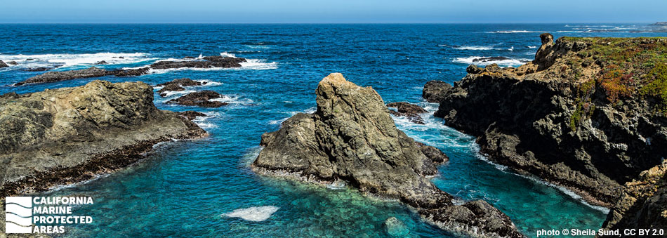
Point Cabrillo State Marine Reserve (SMR) is located off a rocky headland just south of Caspar, between the towns of Fort Bragg to the north and Mendocino to the south. The SMR covers almost half a square mile of ocean habitat. The reserve is a small expansion of an existing MPA at the same location and was incorporated into the statewide MPA network in 2012. The SMR is seaward of Point Cabrillo Light Station State Historic Park, where the Point Cabrillo Lighthouse was built in 1908. The sailing brig Frolic sank nearby in the mid-1800s after striking a reef. The SMR is characterized by beaches, rocky shores, coves, headlands, sandy seafloor, rocky reefs, and kelp forests that support a diversity of marine life including sea urchins, sea cucumbers, anemones, abalone, surfperch, rockfish, halibut, crabs, and scallops.

Regulations

It is unlawful to injure, damage, take, or possess any living, geological, or cultural marine resource.

California Code of Regulations Title 14, Section 632(b)(23)(opens in new tab)

Quick Facts

MPA size: 0.44 square miles

Shoreline span: 1.3 miles

Depth range: 0 to 40 feet

Habitat composition*:

  • Rock: 0.67 square miles
  • Sand/mud: 0.13 square miles

*Habitat calculations are based on 3-dimensional area and may exceed the total MPA area listed above.

About Point Cabrillo State Marine Reserve

Natural History

black snails and algae in a tidepool
Black tegula snails and algae in a tidepool at Point Cabrillo SMR. photo © S. Seamans, CC BY-NC 2.0

Marine terraces line the coast here, and high energy waves crash onto the coastal bluffs, eroding the cliffs to the bedrock. These exposed bluff faces plunge down steeply to the water, forming an almost vertical intertidal zone in many places. A handful of coves and pocket beaches tucked away along this coastline are more protected from wave erosion. The most accessible beach is Frolic Cove Beach near the northern end of the MPA.

The SMR's coastline is mostly composed of rocky shores, and is home to many intertidal organisms specially adapted to withstand the constant pounding of waves. Collections of small barnacles, limpets, and mussels attach to rock faces, while the few tidepools are populated with assemblages of anemones, periwinkles, sea stars, and sea palms. In areas consistently submerged beneath the waves, stalked and feather boa kelp form a low forest, with an understory of coralline algae. Farther offshore, the submerged rocky reef provides a place for kelp to attach and create dense underwater forests. Nearshore fish such as rockfish, cabezon, greenling, lingcod, and surfperch, along with invertebrates common to the general area such as red and purple urchins, abalone, anemones, sea stars, sponges, sea cucumbers, gumboot chitons, crabs, and snails take shelter in the understory.

Cultural History

small light house sits on a bluff overlooking ocean
Point Cabrillo Light Station. photo © Z. Zwang CC BY-NC-ND 2.0

For centuries, Native American Tribes in California have relied on marine and coastal resources. Many Native American Tribes in California continue to regularly harvest marine resources within their ancestral territories and maintain relationships with the coast for ongoing customary uses. The area around Point Cabrillo served as summer hunting grounds for the North Coast Pomo who harvested abalone, mussels, kelp, and salt. The North Coast Pomo people’s word for Point Cabrillo is Ditc’ olel.

The 1850 wreck of the clipper ship Frolic just north of Point Cabrillo helped shape the area’s development. Following the wreck, Harry Meiggs, a San Francisco lumber dealer, sent an agent north to salvage the boat’s cargo. By the time the agent arrived in 1851 the ship had sunk, leaving no cargo to salvage. Instead of salvaged cargo, the agent brought back descriptions of the area's towering redwood forests and stands of Douglas fir. Meiggs quickly arranged for mill equipment to be shipped to Big River. Redwood and Douglas fir trees were harvested, leading to the development of towns and mills along the Mendocino coast and construction of the Point Cabrillo Light Station, built after the 1906 earthquake damaged the Point Arena Lighthouse. The United States Coast Guard took command of this historic light station from 1939 to 1991. The California Coastal Conservancy bought the property in 1991, and restored numerous buildings. California State Parks acquired the light station and surrounding property in 2002.

Recreation

recreational diver underwater with camera next to rusty cylinder covered with urchins
Recreational diver, camera in hand, investigates the remains of the clipper ship Frolic. photo © K. Joe

A walk along the bluff trails in Point Cabrillo Light Station State Historic Park gives visitors panoramic views of this MPA. The headland and trails are open year-round from sunrise to sunset and offer the chance to see marine life from a distance. Visitors to the bluffs can explore the light station buildings, including the lighthouse museum and marine science exhibit. Accessible parking is available in front of the light station residences.

Harbor seals and California sea lions rest on offshore rocks and hunt in the cold waters. Black oystercatchers, with their telltale red beaks, feed on invertebrates along the rocky shore, and gray whale spouts may be spotted rising from the ocean surface as they make their annual migration. For a more immersive experience, scuba and free divers can descend into this MPA and explore Frolic Cove near the northern boundary. Divers can search for the Frolic wreckage while surrounded by marine life. Blue rockfish, black rockfish, kelp rockfish, lingcod, cabezon, and other species frequent the area. Urchins abound on the rocky reef covered in crustose coralline algae, while flatfish like halibut and sole remain motionless on the sandy seafloor waiting for unassuming prey to swim by.

Coordinates

This area is bounded by the mean high tide line and straight lines connecting the following points in the order listed:

39° 21.400 ′ N. lat. 123° 49.418 ′ W. long.;
39° 21.400 ′ N. lat. 123° 50.000 ′ W. long.;
39° 20.600 ′ N. lat. 123° 50.000 ′ W. long.; and
39° 20.600 ′ N. lat. 123° 49.266 ′ W. long.

California Code of Regulations Title 14, Section 632(b)(23)

Downloads for Point Cabrillo State Marine Reserve

Map

Map of Point Cabrillo State Marine Reserve - click to enlarge in new tab

Facts, Map & Regulations

MPA fact sheet - click to enlarge in new tab