Point Buchon State Marine Reserve/State Marine Conservation Area

broad ocean-side view of rocky seaside bluffs

Overview

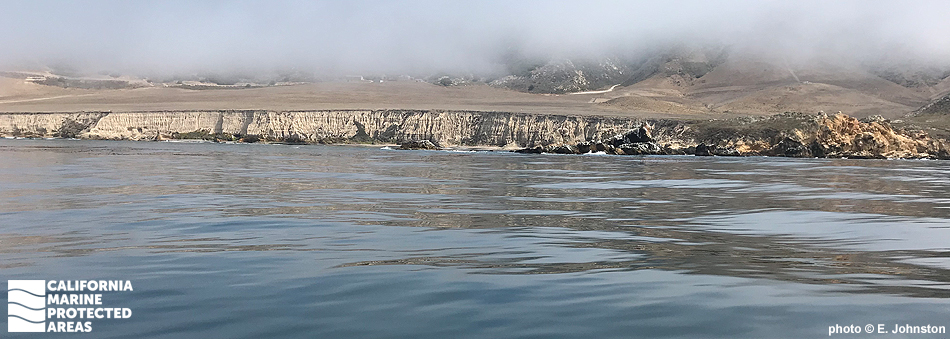
Point Buchon State Marine Reserve (SMR) and Point Buchon State Marine Conservation Area (SMCA) are located eight miles south of Morro Bay in San Luis Obispo County. The onshore-offshore pair of adjoining marine protected areas (MPAs) covers almost 19 square miles of rocky reefs, sandy seafloor and beaches, kelp forests, rocky intertidal areas, and offshore pinnacles. The MPAs also contain some of the shallowest cold-water corals in California.

Point Buchon SMR encompasses more than 6½ square miles of ocean waters and spans 2½ miles of coastline between Coon Creek and the Diablo Canyon nuclear power plant. Point Buchon SMCA sits offshore of the SMR and encompasses more than 12 square miles of waters that range from about 200 to 400 feet deep.

This area of the ocean is highly productive due to local upwelling of nutrients that support plankton and the marine food web. Kelp forests are filled with rockfish, sea stars, gumboot chitons, and abalone, as well as larger visitors like southern sea otters and migrating whales. The neighboring land hosts several winding coastal hiking trails, beaches, and tidepools, and is frequented by whale watchers, hikers, and beachgoers looking for remote, secluded beaches.

Regulations

Point Buchon SMR

It is unlawful to injure, damage, take, or possess any living, geological, or cultural marine resource.

California Code of Regulations Title 14, Section 632(b)(93)(opens in new tab)

Point Buchon SMCA

It is unlawful to injure, damage, take, or possess any living, geological, or cultural marine resource, EXCEPT:
Recreational and commercial take of salmon and albacore is allowed.

California Code of Regulations Title 14, Section 632(b)(94)(opens in new tab)

Quick Facts

Point Buchon SMR

MPA size: 6.68 square miles

Shoreline span: 2.5 miles

Depth range: 0 to 208 feet

Habitat composition*:

  • Rock: 3.83 square miles
  • Sand/mud: 4.90 square miles

Point Buchon SMCA

MPA size: 12.19 square miles

Depth range: 191 to 391 feet

Habitat composition*:

  • Rock: 0.34 square miles
  • Sand/mud: 11.33 square miles

*Habitat calculations are based on 3-dimensional area and may exceed the total MPA area listed above.

Photo Gallery

7 SEP
2022

Southern sea otter at Point Buchon SMR

0

photo © uzun, CC BY-NC 2.0

Showing 0 Comment

Video Gallery

California's MPA Network

About Point Buchon State Marine Reserve/State Marine Conservation Area

Natural History

an otter floating on its back holds an upside down crab on its belly
Southern sea otter with a fine rock crab meal at Point Buchon SMR. photo © D. Ellner, CC BY-NC 2.0

The shoreline and seafloor at Point Buchon are dotted with stunning coves, sea stacks, arches, and underwater pinnacles. Sandy seafloor habitat dominates most of the Point Buchon MPAs, with occasional rocky reefs that harbor a high density of fishes and invertebrates.

Like most of the California coast, these MPAs are in an upwelling zone, where seasonal winds blow surface water away from the coast, causing cold, nutrient-rich water from the deep ocean to rise to the surface. This upwelling supports abundant and diverse habitats and associated marine life communities. The bathymetric complexity, nutrient-rich water, diversity of habitats and thriving invertebrate populations create ideal conditions for many species of fish. Blue rockfish, vermilion rockfish, gopher rockfish, lingcod, California sheephead, and kelp bass are among the species that flourish here.

Point Buchon is well known for the variety and number of marine invertebrates found here. Strawberry anemones cover undersea pinnacles in dense mats, and cold-water corals dot the seafloor, some of the shallowest coral in all of California. Seabirds nest on the offshore rocks, including Brandt’s cormorant, pelagic cormorant, western gull, and pigeon guillemot. Nearshore kelp beds support a large population of southern sea otters that hunt for invertebrates like urchins, abalone, mussels, clams, crabs, and snails, thereby playing an important role in shaping the complex underwater community.

Cultural History

large, striated rock with small arch extrudes from the waterline
Interesting geologic formations at the beach, Point Buchon SMR. photo © M. Baird, CC BY 2.0

For centuries, Native American Tribes in California have relied on marine and coastal resources. Many Native American Tribes in California continue to regularly harvest marine resources within their ancestral territories and maintain relationships with the coast for ongoing customary uses.

The areas surrounding the Point Buchon MPAs and much of the Central Coast are home to the Chumash. Archeological records of Chumash inhabitants reveal evidence of a complex society spanning the coast from Malibu in the south to Morro Bay in the north, including the Channel Islands. In addition to foraging in tidepools and along the coast, the Chumash used large ocean-going canoes, or tomols, to fish, trap marine mammals, and trade amongst villages spread along the Central Coast.

The first Europeans arrived in this area at Montaña de Oro in 1542, but the establishment of permanent European settlements did not occur until the Spanish mission period in the late 1700s. Point Buchon was named after El Buchon, the Chumash chief who ruled this territory when Portola explored it in 1769.

From the early 1800s until the mid-1900s, the land around Montaña de Oro and Point Buchon was almost exclusively private and used for sheep and cattle ranching. On April 24, 1965, Montaña de Oro lands were sold to the State of California and became a State Park. These lands lie just north of the Point Buchon MPAs. The land adjacent to the MPAs is private property belonging to Pacific Gas and Electric, and remains largely undeveloped.

Recreation

kayakers paddle around diagonally striated rock formations
Kayakers among the kelp and offshore rocks at Point Buchon SMR. photo © M. Baird, CC BY 2.0

Point Buchon SMR is relatively remote and usually accessed via a network of coastal trails. Point Buchon SMCA sits offshore of the SMR and can only be reached by boat from Morro Bay. Some of the most scenic and panoramic views of headlands and offshore sea stacks are accessible on a 6.6-mile round-trip hike at the northern end of the Pacific Gas and Electric property, which has been open to the public since 2007. Hikers reach this trail through Montaña de Oro State Park, and must check in with Pacific Gas and Electric at the trailhead.

Most visitors to this MPA are hikers, whale watchers, birders, and occasional beachgoers in search of a private cove. Views of dramatic sea stacks, crystal-clear coves, and excellent tidepooling await rugged adventurers able to climb down to the shoreline. For those with access to a boat, the sea stacks and pinnacles in Point Buchon SMR offer excellent scuba diving. The Point Buchon Pinnacles, although hard to find, are considered an underwater photographer’s paradise. These pinnacles are located 40 feet below the surface and are among the Central Coast’s premier dive sites. Take of marine resources within Point Buchon SMR is prohibited, but salmon and albacore may be taken within Point Buchon SMCA.

Coordinates

Point Buchon SMR

This area is bounded by the mean high tide line and straight lines connecting the following points in the order listed:

35° 15.250′ N. lat. 120° 53.817′ W. long.;
35° 15.250′ N. lat. 120° 56.000′ W. long.;
35° 11.000′ N. lat. 120° 52.400′ W. long.; and
35° 13.348′ N. lat. 120° 52.400′ W. long.

California Code of Regulations Title 14, Section 632(b)(93)

Point Buchon SMCA

This area is bounded by straight lines connecting the following points in the order listed except where noted:

35° 15.250′ N. lat. 120° 56.000′ W. long.;
35° 15.250′ N. lat. 120° 57.878′ W. long.; thence southward along the three nautical mile offshore boundary to
35° 11.000′ N. lat. 120° 55.149′ W. long.;
35° 11.000′ N. lat. 120° 52.400′ W. long.; and
35° 15.250′ N. lat. 120° 56.000′ W. long.

California Code of Regulations Title 14, Section 632(b)(94)

Downloads for Point Buchon State Marine Reserve

Map

Map of Point Buchon State Marine Reserve - click to enlarge in new tab

Facts, Map & Regulations

MPA fact sheet - click to enlarge in new tab

Downloads for Point Buchon State Marine Conservation Area

Map

Map of Point Buchon State Marine Conservation Area - click to enlarge in new tab

Facts, Map & Regulations

MPA fact sheet - click to enlarge in new tab