Point Arena State Marine Reserve/State Marine Conservation Area, and Sea Lion Cove State Marine Conservation Area

lighthouse atop bluffs that rise from rocky shoreline

Overview

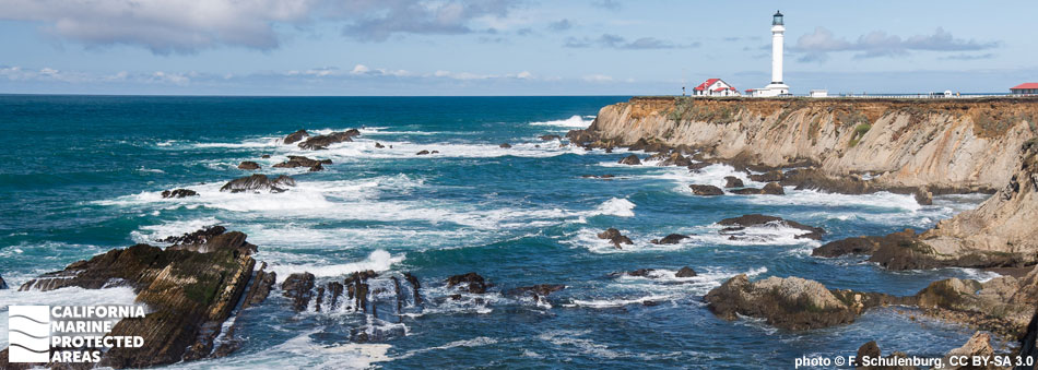
The small city of Point Arena sits on the rugged Mendocino coast 150 miles north of San Francisco. About five miles north of Point Arena, a headland bearing the same name juts out into the Pacific. Point Arena is often cool and shrouded in fog due to strong upwelling of cold ocean waters. Three marine protected areas (MPAs) encompass the biologically diverse and productive marine environment here: Point Arena State Marine Reserve (SMR), Point Arena State Marine Conservation Area (SMCA), and Sea Lion Cove SMCA.

Covering around four square miles of nearshore ecosystems, Point Arena SMR extends from shore to depths of more than 170 feet. The bathymetry of the SMR is extremely complex, with rock walls, cobbled reefs, pinnacles, sheer cliffs, caverns, and a large area of deep, sandy seafloor. Point Arena SMR is located near shore, encompassing tidepools, rocky shores, and kelp beds.

Covering nearly seven square miles of nearshore reef and deep-water ecosystems, Point Arena SMCA lies along the SMR's western boundary, and extends seaward to the 3-mile state waters boundary. The SMCA drops from 150 to over 300 feet deep, with sheer walls, rocky reefs, and large swaths of sand.

Just to the south of the Point Arena SMR and SMCA, Sea Lion Cove SMCA protects about a quarter square mile of primarily rocky seafloor and kelp forest habitat, ranging from shore to depths of around 40 feet. In the aptly named SMCA, sea lions are often found resting on nearshore rocks.

Diverse habitats combined with Point Arena’s strong upwelling and the resulting biodiversity make these MPAs a popular destination for whale watchers, birders, beachgoers, and scuba divers.

Regulations

Point Arena SMR

It is unlawful to injure, damage, take, or possess any living, geological, or cultural marine resource.

California Code of Regulations Title 14, Section 632(b)(28)(opens in new tab)

Point Arena SMCA

It is unlawful to injure, damage, take, or possess any living, geological, or cultural marine resource, EXCEPT:
Recreational and commercial take of salmon by trolling is allowed.

California Code of Regulations Title 14, Section 632(b)(29)(opens in new tab)

Sea Lion Cove SMCA

It is unlawful to injure, damage, take, or possess any living, geological, or cultural marine resource, EXCEPT:
Recreational and commercial take of finfish is allowed.

California Code of Regulations Title 14, Section 632(b)(30)(opens in new tab)

Quick Facts

Point Arena SMR

MPA size: 4.38 square miles

Shoreline span: 2.3 miles

Depth range: 0 to 173 feet

Habitat composition*:

  • Rock: 3.61 square miles
  • Sand/mud: 2.49 square miles

Point Arena SMCA

MPA size: 6.74 square miles

Depth range: 153 to 324 feet

Habitat composition*:

  • Rock: 0.14 square miles
  • Sand/mud: 6.59 square miles

Sea Lion Cove SMCA

MPA size: 0.22 square miles

Shoreline span: 0.7 miles

Depth range: 0 to 39 feet

Habitat composition*:

  • Rock: 0.56 square miles
  • Sand/mud: Less than 0.01 square miles

*Habitat calculations are based on 3-dimensional area and may exceed the total MPA area listed above.

About Point Arena State Marine Reserve/State Marine Conservation Area, and Sea Lion Cove State Marine Conservation Area

Natural History

kelp forest, rockfish
Bull kelp and rockfish at Point Arena SMR. photo © M. Murphy-Cannella, Reef Check California

The MPAs at Point Arena encompass coastal bluffs and pocket coves on land, and sandy seafloors, rocky reefs, walls, and pinnacles at sea. Strong upwelling brings cold, nutrient-rich water from the depths to the surface, making the nearshore ecosystems highly productive. The nutrient-rich waters support abundant plankton populations, which in turn support the rest of the marine food web.

Whales travel year-round past this large headland. Blue and humpback whales migrate between April and December, and gray whales can be sighted from December through April. Seabirds dive beneath the surface to feast on small fish such as anchovies and sardines. Rocky reefs offer vital habitat for kelp, scallops, anemones, basket stars, and gorgonians, while mobile invertebrates, like red sea urchins, purple urchins, sea cucumbers, sea stars, and nudibranchs (sea slugs) hide in the crevices of the rocky reef. Within kelp forests, schools of blue rockfish and black rockfish actively search for food while lingcod lie in wait among the rocks to ambush their prey. Away from rocks and boulders, sea pens, sea whips, and anemones create the only three-dimensional structure along a sandy seafloor. Dungeness crab are occasionally spotted scurrying past more sedentary sea stars, and the sandy backdrop offers ideal camouflage for flatfish.

Sea Lion Cove is in the middle of a two-mile stretch of California coast called the Point Arena-Stornetta Unit, managed by the Bureau of Land Management. This coastline is characterized by several unique geologic features including both collapsed and intact sea caves such as the Devil’s Punchbowl, Satan’s Hole, and the Witches Cauldron Hole. The sea caves, which are nearly horizontal, stand in contrast to the steep, vertical rock forms on shore. This topography creates a rich intertidal ecosystem, notably unique due to the changing rock formations so close to fault lines. Years of erosion have created excellent hiding spots within the rock formations for fish and invertebrates such as rockfish, lingcod, mussels, abalone, and sea stars.

Cultural History

people in small glass turret atop lighthouse
Visitors view Point Arena MPAs from the Point Arena Lighthouse, while an osprey glides by. photo © J. Young, CC BY-NC 2.0

For centuries, Native American Tribes in California have relied on marine and coastal resources. Many Native American Tribes in California continue to regularly harvest marine resources within their ancestral territories and maintain relationships with the coast for ongoing customary uses. The Point Arena region is the traditional territory of the Pomo, a large and diverse group of semi-nomadic people. The Pomo relied on the productive coast for their traditional diet of fish, invertebrates, and plants from the area, with salmon and acorns as staples.

This area was frequented by Russians and native Alaskan hunters as early as 1812 and settled by Mexican landowners in the 1840s. Coastal towns were built by the 1850s as the fur trade grew. Point Arena’s sheltered cove offered protection from the rough Pacific, and served as a harbor for transporting timber, gold, and fish. The first wharf was built in 1866, turning Point Arena into a bustling shipping port for redwood and other goods.

In 1866, the United States government ordered the construction of a lighthouse on Point Arena to protect ships traveling in the challenging ocean conditions north of San Francisco. The original lighthouse was badly damaged by the 1906 earthquake that devastated San Francisco. A second lighthouse was built a year later. Standing at 115 feet tall, the Point Arena Lighthouse still holds the original Fresnel lens and casts a beam of light visible to ships 20 miles out to sea.

Recreation

entrance through fence to trail beyond
Entrance to the trail to Sea Lion Cove SMCA. photo © L. Kashiwada

The Point Arena-Stornetta Public Lands are located adjacent to the MPAs, affording visitors sweeping vistas of the Pacific on their way to the Point Arena Lighthouse. The lighthouse hosts a small museum and visitors center, with lodging for those who want to spend the night there.

The coastal trails offer visitors opportunities to watch waves crashing against the bluffs, observe seals and sea lions hauled out on the rocks to rest, and the chance to spy a passing whale as it swims through the nutrient-rich waters. Bird watchers can also observe seabirds including black oystercatchers as they scour the rocks for a meal, and pelagic cormorants and pigeon guillemots diving beneath the surface to feed on small fish.

Arena Rock is a popular scuba diving site. Remember when visiting the SMR, no take is allowed as all marine resources are protected. Point Arena SMCA only allows trolling for salmon; all other take is prohibited there. In the Sea Lion Cove SMCA, finfish may be taken, but no other take is allowed.

Coordinates

Point Arena SMR

This area is bounded by the mean high tide line and straight lines connecting the following points in the order listed:

38o 57.350 ′ N. lat. 123o 44.500 ′ W. long;
38o 59.000 ′ N. lat. 123o 44.500 ′ W. long;
38o 59.000 ′ N. lat. 123o 46.000 ′ W. long;
38o 56.400 ′ N. lat. 123o 46.000 ′ W. long; and
38o 56.400 ′ N. lat. 123o 43.820 ′ W. long.

California Code of Regulations Title 14, Section 632(b)(28)

Point Arena SMCA

This area is bounded by straight lines connecting the following points in the order listed except where noted:

38o 59.000 ′ N. lat. 123o 46.000 ′ W. long.;
38o 59.000 ′ N. lat. 123o 48.162 ′ W. long.; thence southward along the three nautical mile offshore boundary to
38o 56.400 ′ N. lat. 123o 48.350 ′ W. long.;
38o 56.400 ′ N. lat. 123o 46.000 ′ W. long.; and
38o 59.000 ′ N. lat. 123o 46.000 ′ W. long.

California Code of Regulations Title 14, Section 632(b)(29)

Sea Lion Cove SMCA

This area is bounded by the mean high tide line and straight lines connecting the following points in the order listed:

38o 56.400 ′ N. lat. 123o 43.820 ′ W. long.;
38o 56.400 ′ N. lat. 123o 44.000 ′ W. long.;
38o 55.790 ′ N. lat. 123o 44.000 ′ W. long.; and
38o 55.790 ′ N. lat. 123o 43.740 ′ W. long.

California Code of Regulations Title 14, Section 632(b)(30)

Downloads for Point Arena State Marine Reserve

Map

Map of Point Arena State Marine Reserve - click to enlarge in new tab

Facts, Map & Regulations

MPA fact sheet - click to enlarge in new tab

Downloads for Point Arena State Marine Conservation Area

Map

Map of Point Arena State Marine Conservation Area - click to enlarge in new tab

Facts, Map & Regulations

MPA fact sheet - click to enlarge in new tab

Downloads for Sea Lion Cove State Marine Conservation Area

Map

Map of Sea Lion Cove State Marine Conservation Area - click to enlarge in new tab

Facts, Map & Regulations

MPA fact sheet - click to enlarge in new tab