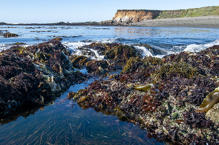
 Tidepools near Point Sierra Nevada, Piedras Blancas SMR. photo © R. Schwemmer, NOAA.
Piedras Blancas SMR is well known for its colorful tidepools, which harbor invertebrates such as sea stars and limpets, and for its sand and cobble beaches. The SMR’s deep rocky reef attracts large fish such as lingcod, cabezon, and multiple species of rockfish including brown rockfish, treefish, and blue rockfish. The extensive kelp beds provide habitat and hunting grounds for diverse marine species including California sheephead, sharks, and rays.
Historically, the Piedras Blancas area was one of the most productive abalone fishing grounds in California. Intense abalone fishing in the 1960s coupled with disease resulted in significant declines in abalone populations, and the fishery was closed south of San Francisco in the mid-1990s.
Nearshore rocks and islets serve as haul-out sites for marine mammals such as harbor seals and sea lions. Seabirds like black oystercatchers and brown pelicans rest and build their nests on these nearshore rocks.
The beaches of Piedras Blancas are perhaps best known for their northern elephant seal rookeries, the largest concentration south of Año Nuevo. Elephant seals come ashore three times annually to mate and give birth, to molt, and to rest. In the nearly twenty years since the first pup was born here, the colony has grown to upwards of 25,000 northern elephant seals.
Beneath the ocean’s surface, the seafloor at Piedras Blancas SMCA has many hills and valleys due to the presence of two different fault systems: the offshore Santa Lucia Bank Fault, and the onshore San Simeon-Hosgri Fault systems. Brilliant green minerals called Coast Range ophiolite or “snakestone” dot the seafloor. These ophiolite rocks are at least 185 million years old and are surrounded by much newer marine deposits and sand that are less than 12,000 years old. The presence of such old and new rocks at the same depth on the seafloor is rare, and offers proof of an ever-changing seafloor.
Within the SMCA, a large area of deepwater rocky reef habitat attracts baitfish such as Pacific sardines, anchovies, herring, and market squid. The reef also provides hunting grounds and shelter for rockfish including gopher rockfish, vermilion rockfish, and blue rockfish.
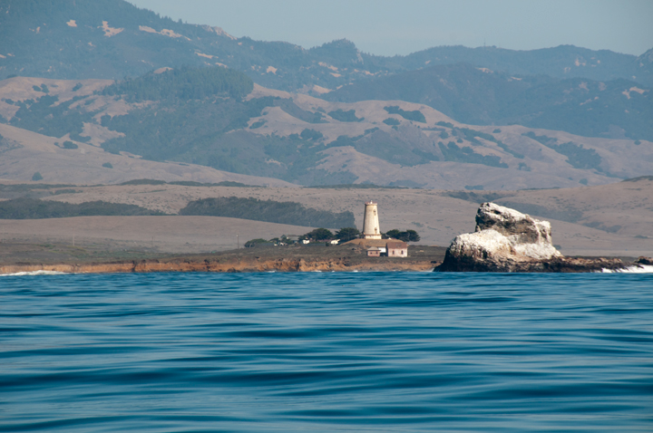 Piedras Blancas Light Station. photo © R. Schwemmer, NOAA.
For centuries, Native American Tribes in California have relied on marine and coastal resources. Many continue to regularly harvest marine resources within their ancestral territories and maintain relationships with the coast for ongoing customary uses.
Piedras Blancas is a site of cultural interface between the Northern Chumash Tribe and the Playanos Salinan people. The Playanos lived in small groups on the coast near present-day San Simeon, but moved inland during the late summer and fall each year to harvest nuts, berries, and other edible plants.
In 1821, when California was under Mexican rule, the Mexican government awarded Don Jose de Jesus Pico close to 49,000 acres of land that came to be known as Rancho de la Piedra Blanca. Around 1854, Pico started selling off his land holdings, and in 1865 George Hearst began incremental acquisition of acreage surrounding present day San Simeon, including Piedras Blancas. Land owned by Mr. Hearst and later by his son, William Randolph Hearst, became the 270,000-acre Hearst Ranch.
The Piedras Blancas Light Station was first illuminated in 1875. The light station tower was originally 100 feet tall, but in 1949 the upper portion of the tower was removed due to earthquake damage, reducing the height to 70 feet. The light station is currently operated by the Bureau of Land Management and the Piedras Blancas Light Station Association.
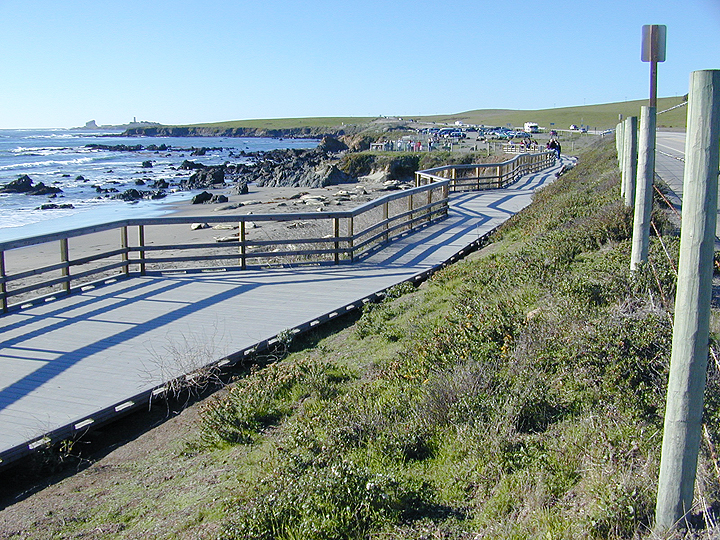 Viewing platform for observing northern elephant seals on the beach, Piedras Blancas SMR. photo © D. Endico, CC BY-NC 2.0.
Many recreational opportunities exist within the SMR and SMCA, but the most popular and common activity for all ages is viewing the northern elephant seals. Access to the rookery observation platforms is free, and they are open to the public 365 days a year. Parking lots are located about one mile south of the entrance to Piedras Blancas Light Station Natural Area. Accessible boardwalks are available on the north and south side of the parking lot, and paths lead to observation platforms above seal-lined beaches. Visitors must remain on the viewing platform while observing these marine mammals. The best time to view young pups and active adults is late December through early March, but seals of various age groups are present year-round. Peak times are January, April, and October.
Kayakers, surfers, and divers are all welcome to enjoy the waves and underwater scenery, but must access the SMR from an area outside of the seal viewing area. San Simeon Beach lies close by and offers excellent tidepooling. Visitors should note that take of any marine resource is prohibited within the SMR. In the offshore SMCA, anglers may fish for salmon and albacore.
Piedras Blancas SMR
This area is bounded by the mean high tide line and straight lines connecting the following points in the order listed:
35° 42.850′ N. lat. 121° 18.950′ W. long.;
35° 42.850′ N. lat. 121° 21.000′ W. long.;
35° 39.150′ N. lat. 121° 18.500′ W. long.; and
35° 39.150′ N. lat. 121° 14.519′ W. long.
California Code of Regulations Title 14, Section 632(b)(87)
Piedras Blancas SMCA
This area is bounded by straight lines connecting the following points in the order listed except where noted:
35° 42.850′ N. lat. 121° 21.000′ W. long.;
35° 42.850′ N. lat. 121° 22.763′ W. long.; thence southward along the three nautical mile offshore boundary to
35° 39.150′ N. lat. 121° 20.913′ W. long.;
35° 39.150′ N. lat. 121° 18.500′ W. long.; and
35° 42.850′ N. lat. 121° 21.000′ W. long.
California Code of Regulations Title 14, Section 632(b)(88)