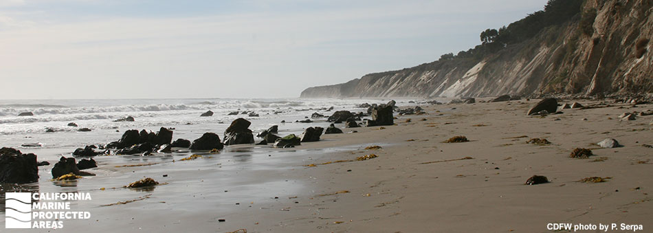
Naples State Marine Conservation Area

steep cliffsides meet white seafoam extending out to the horizon, dark boulders extend out from the sand and surf

Overview

Naples State Marine Conservation Area (SMCA), encompassing less than three square miles, is one of the smaller marine protected areas (MPAs) in California. Despite its small size, this SMCA is considered an ecological hot spot. It is located just west of the city of Santa Barbara, offshore of the rural Gaviota Coast, and adjacent to El Capitán State Beach. The MPA protects a unique offshore rocky reef brimming with exceptional seafloor diversity, intertidal areas, surfgrass, kelp forest, and a harbor seal haul-out.

Offshore, the seascape includes a 30-foot reef wall covered in marine life, unique underwater pinnacle and arch systems, networks of caves, and thick kelp forests that provide homes for anemones, nudibranchs, cowries, and fish like kelp bass, California sheephead, white seabass, and yellowtail. This iconic area is frequently visited by divers, surfers, kayakers, and scientists conducting long-term research and monitoring. Marine mammals are easy to spot from shore, with sea lions feeding near the shallow rocky reef and harbor seals sunning on the coastal rocks.

Regulations

It is unlawful to injure, damage, take, or possess any living, geological, or cultural marine resource, EXCEPT:
Recreational take of white seabass and pelagic finfish (northern anchovy, barracudas, billfishes, dorado (dolphinfish), Pacific herring, jack mackerel, Pacific mackerel, salmon, Pacific sardine, blue shark, salmon shark, shortfin mako shark, thresher shark, swordfish, tunas, Pacific bonito, and yellowtail) by spearfishing is allowed. Commercial take of giant kelp is allowed. Includes take exemptions for the following tribe:

  • Santa Ynez Band of Chumash Indians

California Code of Regulations Title 14, Section 632(b)(98)(opens in new tab)

Quick Facts

MPA size: 2.60 square miles

Shoreline span: 1.9 miles

Depth range: 0 to 162 feet

Habitat composition*:

  • Rock: 1.48 square miles
  • Sand/mud: 2.00 square miles

*Habitat calculations are based on three-dimensional area and may exceed the total MPA area listed above.

About Naples State Marine Conservation Area

Natural History

black and yellow rockfish rests in a rock crevice
Black-and-yellow rockfish in Naples SMCA. photo © Santa Barbara Channel Marine Biodiversity Observation Network, CC BY-NC 2.0.

The seafloor here is structurally complex. Cathedral-like outcroppings, caverns, shelves, and arches combine with significant surges and currents that bring intrusions of nutrient-rich seawater to create a unique habitat. This SMCA protects Naples Reef, an underwater pinnacle and cave system located about a mile offshore. While small in size, Naples Reef is an exceptionally dynamic, fertile habitat, with anemone-covered walls rising 30 feet from the seafloor, a thick kelp forest hosting a variety of fish like kelp bass and rockfish species, as well as nudibranchs, red gorgonians, California spiny lobster, and a variety of crabs and scallops.

At the surface, sea lions, pelicans and harbor seals swim and hunt for prey. The ocean waters here are continually enriched by the mixing of currents that bring both cold-water, northern species and warmer-water, southern species to the area, producing a transition zone of increased biodiversity.

Additionally, strong winds drive upwelling that brings cold, nutrient-rich water up from the deep to fuel a productive food web including plankton, squid, sardines, dolphins, sharks, birds, and whales. The shoreline of Naples SMCA is known as the Gaviota Coast, one of the largest stretches of undeveloped coastal land in Southern California and one of the most important ecological regions in the state and possibly the world. It is home to 1,400 plant and animal species, over 20 of which are listed as threatened or endangered. Naples Reef, within the SMCA, is part of this biodiversity hotspot.

Cultural History

chestnut cowry on sandy substrate
Chestnut cowry in Naples SMCA. photo © J. Goddard, CC BY-NC 2.0.

For centuries, Native American Tribes in California have relied on marine and coastal resources. Many Native American Tribes in California continue to regularly harvest marine resources within their ancestral territories and maintain relationships with the coast for ongoing customary uses.

The Santa Barbara area surrounding the SMCA was first settled by Native Americans at least 13,000 years ago. Archeological records of Chumash inhabitants reveal evidence of a complex society that existed from Malibu in the south to Morro Bay in the north, including the Channel Islands. Chumash ancestors fostered societies of great complexity and adaptability, and established important trade routes. The tomol, the traditional Chumash redwood plank canoe, was an essential mode of transportation for trade and fishing. Today, contemporary Chumash peoples continue to nurture and revitalize the lifeways of those ancestors.

Spanish explorers under the command of Juan Rodriguez Cabrillo first encountered the Chumash in 1542. The foreign European presence introduced disease epidemics that drastically reduced the Chumash population, yet descendants still reside in the area today. Through a factual record of historical take within the Naples SMCA, the Santa Ynez Band of Chumash Indians is exempt from regulations of the MPA.

Recreation

bright ping and orange sea slug on sandy substrate
A Spanish shawl (nudibranch) in Naples SMCA. photo © J. Goddard, CC BY 2.0.

Parking and beach access is available at El Capitán State Beach, which lies north of the SMCA, or from Haskell's Beach which lies south. A few miles of hiking along the coast from either location during a low tide, or kayaking/boating from either location, will bring you to Naples SMCA. Activities such as kayaking, diving, snorkeling, and swimming are allowed in the SMCA, and spearfishermen can target white seabass and pelagic finfish.

Naples Reef, located offshore, is known as one of the most scenic coastal dives in Southern California. While diving and snorkeling are fantastic, these activities should only be undertaken by advanced divers due to often significant surges and currents. During low tide, tidepooling opportunities abound, but please remember to take only pictures and to never remove or pick up animals, shells, or rocks from tidepools.

Coordinates

This area is bounded by the mean high tide line and straight lines connecting the following points in the order listed:

34° 26.517' N. lat. 119° 58.000' W. long.;
34° 25.000' N. lat. 119° 58.000' W. long.;
34° 25.000' N. lat. 119° 56.000' W. long.; and
34° 26.140' N. lat. 119° 56.000' W. long.

California Code of Regulations Title 14, Section 632(b)(98)

Printable Downloads

Map

Map of Naples State Marine Conservation Area - click to enlarge in new tab

Facts, Map & Regulations

MPA fact sheet - click to enlarge in new tab

Photo Gallery

19 AUG
2022

Plainfin midshipman in Naples SMCA

0

photo © J. Goddard , CC BY-NC 2.0

Showing 0 Comment

Marine Region (Region 7)
Regional Manager: Dr. Craig Shuman
Main Office: 20 Lower Ragsdale Drive, Suite 100, Monterey, CA  93940
Email CDFW's Marine Region  |  (831) 649-2870
Office Locations  |  Marine Blog  |  Subscribe