Judith Rock State Marine Reserve, and San Miguel Island Special Closure

aerial view of island with many coves

Overview

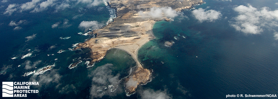
Judith Rock State Marine Reserve (SMR) lies on the southwest coast of San Miguel Island, the westernmost of California’s Channel Islands. This marine protected area (MPA) protects more than 4½ square miles of ocean habitat including surfgrass beds, rocky reefs, and kelp forests, and reaches depths approaching 500 feet.

Cold water from the north and warm water from the south mix here, creating complex circulation patterns and species diversity. Marine life in the waters surrounding San Miguel Island most closely resembles northern California's because of the strong influence of cold waters from the north. Invertebrates such as mussels, anemones, abalone, and barnacles thrive in the reserve’s rocky intertidal area, and sculpins and other small fish find refuge in bedrock pools. The SMR's extensive kelp forests are home to lingcod, kelp bass, and rockfish.

San Miguel Island Special Closure runs the length of the island's western coastline, from Castle Rock to Judith Rock. The special closure (and the reserve) protects some of the largest seal and sea lion rookeries in the country. Several species can be spotted, especially on sandy beaches. In winter, as many as 50,000 seals and sea lions haul out at Point Bennett, a promontory connected to the main island by stretches of sandy beach. To give them a safe place to haul out and give birth, the year-round special closure prohibits boats from approaching the shore closer than 300 yards. However, from March 15 through April 30, and October 1 through December 15, the closure is reduced to 100 yards from shore. Other prohibitions exist as well in this unique area.

Although not out of reach, visiting San Miguel Island requires a three-to-four-hour boat ride from Ventura Harbor.

Regulations

Judith Rock SMR

It is unlawful to injure, damage, take, or possess any living, geological, or cultural marine resource.

California Code of Regulations Title 14, Section 632(b)(104)(opens in new tab)

San Miguel Island Special Closure

Boating, access, and other specific activities are restricted.

300 yd. closure except:

The closure is reduced to 100 yd. from March 15 through April 30, and October 1 through December 15.

Boats operated by commercial sea urchin divers may enter certain areas only between March 15 and April 30, and October 1 through December 15.

Additional restrictions exist for boating speed limits, noise, anchoring, landing, and access to offshore rocks and islands. See CCR T14 §632(b) (link below) for details.

California Code of Regulations Title 14, Section 632(b)(102)(opens in new tab)

Quick Facts

Judith Rock SMR

MPA size: 4.56 square miles

Shoreline span: 1.4 miles

Depth range: 0 to 487 feet

Habitat composition*:

  • Rock: 0.54 square miles
  • Sand/mud: 1.78 square miles

San Miguel Island Special Closure

Special Closure size: 0.86 square miles

Depth range: 0 to 55 feet

Habitat composition*:

  • Rock: 0.71 square miles
  • Sand/mud: 0.01 square miles

*Habitat calculations are based on 3-dimensional area and may exceed the total MPA area listed above.

Photo Gallery

30 AUG
2022

Point Bennett, San Miguel Island Special Closure

0

photo © R. Schwemmer, NOAA

Showing 0 Comment

Video Gallery

Southern California Marine Protected Area Highlights

California's MPA Network

About Judith Rock State Marine Reserve, and San Miguel Island Special Closure

Natural History

sea lions swimming and on a sandy beach
California sea lions at San Miguel Island Special Closure. photo © J. Harris, NOAA Fisheries, CC BY-NC-ND 2.0

San Miguel Island has a jagged, rocky coastline interspersed with sandy beaches. Its exposure to the wind and open ocean makes it unique and contributes to an array of life not found on the other, less exposed islands.

Judith Rock SMR and San Miguel Island Special Closure, like the rest of the Northern Channel Islands MPAs and special closures, are located where warm water currents from the tropics and cold water currents from Alaska converge. This mix of temperatures combined with upwelled nutrients from the deep and the meeting of species from southern and northern ranges account for the rich and varied marine life found here.

San Miguel Island is the westernmost island in the Northern Channel Islands chain, which makes it more heavily influenced by the cold California Current. Species that thrive in colder water temperatures such as sunflower sea stars, black rockfish, and red abalone are common around San Miguel Island, where the marine life generally is more similar to that of northern California.

Point Bennett, at the extreme western end of the island in San Miguel Island Special Closure, is one of the largest seal and sea lion breeding areas in the world. Northern fur seals, harbor seals, elephant seals, and California sea lions are commonly spotted. Steller sea lions and Guadalupe fur seals also occasionally visit the island. The peak breeding season at Point Bennett and the surrounding beaches is May and June, but seals and sea lions can be spotted onshore year-round sunning themselves, mating, sparring, and pupping. During breeding and pupping seasons, more than 70,000 California sea lions, 5,000 northern fur seals, and 50,000 northern elephant seals can be found on the beaches.

The rest of the mostly rocky shoreline near the SMR and special closure stretches for more than five miles. Patches of surfgrass line the diverse and rich rocky intertidal habitat, home for crabs, shrimps, and other invertebrates. Farther offshore, red abalone, urchins, sponges, nudibranchs, and anemones add vibrant color to the rocky reefs. Large crevices and ledges in the reefs create excellent habitat for octopus and wolf-eels. Kelpfish, copper rockfish, lingcod, California sheephead, painted greenlings, and vermilion rockfish are abundant.

Cultural History

sea lions on shore
California sea lions at San Miguel Island Special Closure. photo © S. Melin, NOAA Fisheries, CC BY-NC-ND 2.0

For centuries, Native American Tribes in California have relied on marine and coastal resources. Many continue to regularly harvest marine resources within their ancestral territories and maintain relationships with the coast for ongoing customary uses.

San Miguel Island is a traditional home of the Chumash, who occupied the island almost continuously for thousands of years. Two historic Native American village sites have been discovered on the island to date. The Chumash developed a complex maritime culture that relied heavily on the area’s abundant marine resources for the staples of their diet. They used the tomol, a traditional redwood plank canoe, and extensive knowledge of the ocean to trade with mainland and other Channel Islands tribes. The Chumash remained on the island until the 1820s, when they were moved to the mainland.

In 1542, the European explorer Juan Cabrillo spent several weeks on San Miguel Island while he and his crew explored the Santa Barbara Channel, and some suspect that Cabrillo died on the island after an infection turned gangrenous. By the 1840s, sheep ranching flourished on the island. Herbert Lester, the self-proclaimed “King of San Miguel,” and his family homesteaded the island until the attack on Pearl Harbor, which forced them to flee to the mainland. During World War II, the Navy took control of the island and built multiple lookout structures, eventually using the island for target practice as part of its Pacific Missile Range for guided missiles and bombing in 1948. Today, the Navy retains ownership of the island, but it is managed by the National Park Service as part of Channel Islands National Park.

Channel Islands National Park was established in 1980 to protect San Miguel, Santa Rosa, Santa Cruz, Anacapa and Santa Barbara islands, replacing the previously designated Channel Islands National Monument that had only protected Anacapa and Santa Barbara islands. The Channel Islands National Marine Sanctuary was also established in 1980, protecting 1,470 square miles of ocean up to six nautical miles offshore around each of the five islands.

Recreation

people viewing sea lions at the beach
Researchers observing sea lions at San Miguel Island Special Closure. photo © S. Melin, NOAA Fisheries, CC BY-NC-ND 2.0

Those interested in taking advantage of San Miguel Island's numerous recreational opportunities can take the three-to-four-hour journey by boat using several charter companies. You can also use your own boat to get there, but anchoring is limited to Tyler Bight, just east of the SMR, or Cuyler Harbor. The island is only open when a ranger is present, and you must obtain a permit (exception: if traveling to San Miguel Island with an established guide outfit, they provide the permit upon reservation). Private boaters can obtain a permit at a self-registration station at the Nidever Canyon trailhead entry on San Miguel Island.

Point Bennett, one of the largest seal and sea lion breeding areas in the world, can be reached on a ranger-led hike. Fourteen miles round-trip, the hike ends at an overlook where visitors can see elephant seals, California sea lions, northern fur seals, and harbor seals on the beaches below. Due to the island’s prior use as a military testing site, visitors are not permitted to hike off-trail since there is the risk of encountering unexploded weaponry.

No food, water, or amenities are available on the island, and visitors should come prepared to encounter winds greater than 50 knots. Ten campsites are located near the historic Lester Ranch site, which has picnic tables and one pit toilet. The harsh but magnificent terrain makes preparation a must for anyone interested in exploring the island. Aquatic activities like snorkeling, diving, and kayaking are recommended for experienced swimmers only because of the strong winds and currents. Campers and other visitors must pack out their trash.

Coordinates

Judith Rock SMR

This area is bounded by the mean high tide line and straight lines connecting the following points in the order listed except where noted:

34° 01.802′ N. lat. 120° 26.600′ W. long.;
33° 58.513′ N. lat. 120° 26.600′ W. long.; thence eastward along the three nautical mile offshore boundary to
33° 58.518′ N. lat. 120° 25.300′ W. long.; and
34° 01.689′ N. lat. 120° 25.300′ W. long.

California Code of Regulations Title 14, Section 632(b)(104)

San Miguel Island Special Closure

Boating is allowed at San Miguel Island except west of a line drawn between Judith Rock (34° 01.500′ N. lat. 120° 25.300′ W. long.) and Castle Rock (34° 03.300′ N. lat. 120° 26.300′ W. long.) where boats are prohibited closer than 300 yards from shore.

Notwithstanding the 300-yard boating closure between Judith Rock and Castle Rock, the following shall apply: Boats may approach San Miguel Island no nearer than 100 yards from shore during the period(s) from March 15 through April 30, and October 1 through December 15; and

Boats operated by commercial sea urchin divers may enter waters of the 300-yard area between the western boundary of the Judith Rock State Marine Reserve at 120° 26.60′ W. long. and Castle Rock for the purpose of fishing sea urchins during the period(s) from March 15 through April 30, and October 1 through December 15.

The department may rescind permission for boats to enter waters within 300 yards between Judith Rock and Castle Rock upon finding that impairment to the island marine mammal resource is imminent.

Boats traveling within 300 yards of the shoreline or anchorages shall operate with a minimum amount of noise and shall not exceed speeds of five miles per hour.

Except as permitted by federal law or emergency caused by hazardous weather, boats may be anchored overnight only at Tyler Bight and Cuyler Harbor.

Landing is allowed on San Miguel Island only at the designated landing beach in Cuyler Harbor.

No person shall have access to all other offshore rocks and islands at San Miguel Island.

California Code of Regulations Title 14, Section 632(b)(102)

Downloads for Judith Rock State Marine Reserve

Map

Map of SMR - click to enlarge in new tab

Facts, Map & Regulations

MPA fact sheet - click to enlarge in new tab

Downloads for San Miguel Island Special Closure

Map

Map of Special Closure - click to enlarge in new tab

Facts, Map & Regulations

MPA fact sheet - click to enlarge in new tab