Harris Point State Marine Reserve/Federal Marine Reserve

aerial view of island in the ocean

Overview

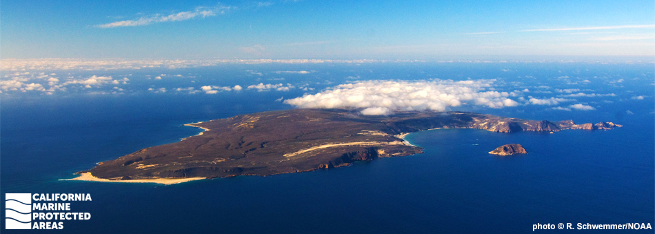
San Miguel Island, the westernmost of the Channel Islands, has a jagged, rocky coastline dotted with sandy beaches. Its exposure to the wind and open ocean makes it unique and contributes to an array of life not found on the other, less exposed islands. Harris Point State Marine Reserve (SMR) and the federal Harris Point Marine Reserve (FMR) extend north from the island. These remote marine protected areas (MPAs) are located about a 60-mile boat ride from Ventura Harbor.

Protecting more than 25 square miles of marine habitat, Harris Point SMR encompasses rocky reef, kelp forest, and sandy seafloor ecosystems, which support a variety of marine life. Where the SMR ends at three nautical miles from shore, the FMR continues farther offshore to meet the outer boundary of the surrounding Channel Islands National Marine Sanctuary.

California spiny lobsters, wolf-eels, rockfish, Risso’s dolphins, northern elephant seals, and white sharks are frequently observed here. Harris Point SMR lies near one of the largest sea lion breeding colonies in the world, and San Miguel Island itself includes one of the oldest archaeological sites in California. The island's unique environment, wildlife, and history attract biologists, archaeologists, and adventure seekers year-round.

Regulations

It is unlawful to injure, damage, take, or possess any living, geological, or cultural marine resource.

California Code of Regulations Title 14, Section 632(b)(103)(opens in new tab)

Note: The state and federal marine reserves share identical regulations.

Quick Facts

These facts are for the state marine reserve only.

MPA size: 25.40 square miles

Shoreline span: 7 miles

Depth range: 0 to 557 feet

Habitat composition*:

  • Rock: 4.62 square miles
  • Sand/mud: 22.08 square miles

*Habitat calculations are based on 3-dimensional area and may exceed the total MPA area listed above.

Photo Gallery

26 AUG
2022

Cuyler Harbor, near Harris Point SMR

0

photo © R. Schwemmer, NOAA

Showing 0 Comment

Video Gallery

Southern California Marine Protected Area Highlights

California's MPA Network

About Harris Point State Marine Reserve/Federal Marine Reserve

Natural History

bright red rockfish
Vermilion rockfish on a rocky reef at Harris Point SMR. photo © MARE

Harris Point SMR encompasses two underwater ecosystems. The first is the more exposed Simonton Cove to the west, characterized by sandy seafloor and offshore rocky reefs. The second is the more sheltered stretch of coast from Harris Point to Bat Cove (excluding Cuyler Harbor), which is punctuated by towering rock formations and pinnacles cloaked in kelp forests. Divers report sighting large lingcod, white seabass, kelp bass, California halibut, and multiple species of rockfish in the kelp forests, and more frequent sightings of red abalone and black abalone, which were once severely depleted. The offshore portion of the SMR and FMR protects deepwater habitat consisting mainly of sandy seafloor with the occasional rocky reef.

San Miguel Island is recognized as an "Important Bird Area" by the Audubon Society. The island is home to one-third of the Channel Islands’ breeding seabirds, which includes 13 different species and more than 33,000 breeding birds. A large outcrop just outside of Cuyler Harbor known as Prince Island is one of the most important and biologically diverse nesting sites on the West Coast. All 13 seabird species nest here, including Cassin's auklets, ashy storm-petrels, and Brandt’s cormorants. The surrounding waters offer a steady supply of food for these avian visitors.

Cultural History

island in the sea
Prince Island, an important seabird nesting area at Harris Point SMR. photo © M. Baird, CC BY 2.0

For centuries, Native American Tribes in California have relied on marine and coastal resources. Many continue to regularly harvest marine resources within their ancestral territories and maintain relationships with the coast for ongoing customary uses.

San Miguel Island is a traditional home of the Chumash, who occupied the island almost continuously for thousands of years. Two historic Native American village sites have been discovered on the island to date. The Chumash developed a complex maritime culture that relied heavily on the area’s abundant marine resources for the staples of their diet. Primitive piles of shells left by Native Americans, known as shell middens, were discovered in Daisy Cave, just east of Bay Point within the SMR. They are some of the oldest shell middens in North America. The Chumash used the tomol, a traditional redwood plank canoe, and extensive knowledge of the ocean to trade with tribes on the mainland and with other Channel Islands tribes. The Chumash remained on the island until the 1820s, when they were moved to the mainland.

In 1542, the European explorer Juan Cabrillo spent several weeks on San Miguel Island while he and his crew explored the Santa Barbara Channel, and some suspect that Cabrillo died on the island after an infection turned gangrenous. By the 1840s, sheep ranching flourished on the island. Herbert Lester, the self-proclaimed “King of San Miguel,” and his family homesteaded the island until the attack on Pearl Harbor, which forced them to flee to the mainland. During World War II, the Navy took control of the island and built multiple lookout structures, eventually using the island for target practice as part of its Pacific Missile Range for guided missiles and bombing in 1948. Today, the Navy retains ownership of the island, but it is managed by the National Park Service as part of Channel Islands National Park.

Channel Islands National Park was established in 1980 to protect San Miguel, Santa Rosa, Santa Cruz, Anacapa and Santa Barbara islands, replacing the previously designated Channel Islands National Monument that had only protected Anacapa and Santa Barbara islands. The Channel Islands National Marine Sanctuary was also established in 1980, protecting 1,470 square miles of ocean up to six nautical miles offshore around each of the five islands.

Recreation

kayaker paddling into sea cave
Kayaker explores a cave in Harris Point SMR. photo © M. Baird, CC BY 2.0

Due to its isolation and protection, San Miguel Island is a rare example of a relatively well-recovered native ecosystem. Hiking on designated trails is very popular, while snorkeling, diving, and kayaking are recommended for experienced visitors only, due to strong winds and currents. There is no fishing or take of any kind permitted within Harris Point SMR or Harris Point FMR.

Those interested in taking advantage of San Miguel Island's numerous recreational opportunities can travel there by boat with several charter companies. You can also use your own boat to get there, but anchoring is limited to Cuyler Harbor and Tyler Bight. The island is only open when a ranger is present, and you must obtain a permit (exception: if traveling to San Miguel Island with an established guide outfit, they provide the permit upon reservation). Private boaters can obtain a permit at a self-registration station at the Nidever Canyon trailhead entry on San Miguel Island.

Visitors are not permitted to hike off-trail since there is a risk of encountering unexploded weaponry, a legacy of the island’s prior use as a military testing site. Visitors must be accompanied by a ranger to all island locations except for Cuyler Harbor Beach, Nidever Canyon, Cabrillo Monument, and Lester Ranch.

No food, water, or amenities are available on the island, and visitors should come prepared to encounter winds greater than 50 knots. The harsh but magnificent terrain makes preparation a must. Ten campsites are located near the historic Lester Ranch site. Campers and other visitors must pack out their trash.

Coordinates

This area is bounded by the mean high tide line and straight lines connecting the following points in the order listed:

34° 03.160' N. lat. 120° 23.300' W. long.;
34° 12.295' N. lat. 120° 23.300' W. long.;
34° 12.295' N. lat. 120° 18.400' W. long.; and
34° 01.755' N. lat. 120° 18.400' W. long.

An exemption to the reserve, where commercial and recreational take of living marine resources is allowed, exists between the mean high tide line in Cuyler Harbor and a straight line between the following points:

34° 03.554' N. lat. 120° 21.311' W. long.; and
34° 02.908' N. lat. 120° 20.161' W. long.

Note: The first four coordinates provided here describe the outer boundaries of the joined Harris Point State Marine Reserve and federal Harris Point Marine Reserve.

The state reserve and federal reserve share identical regulations. For state reserve boundaries only, see California Code of Regulations Title 14, Section 632(opens in new tab). For federal reserve boundaries only, see Code of Federal Regulations, Federal Register 15 Part 922 and 50 CFR Part 660.

Downloads for Harris Point State Marine Reserve / Federal Marine Reserve

Map

Map of Harris Point SMR and Harris Point Marine Reserve - click to enlarge in new tab

Facts, Map & Regulations

MPA fact sheet - click to enlarge in new tab