Egg (Devil's Slide) Rock to Devil's Slide Special Closure

large rocks protruding from ocean

Overview

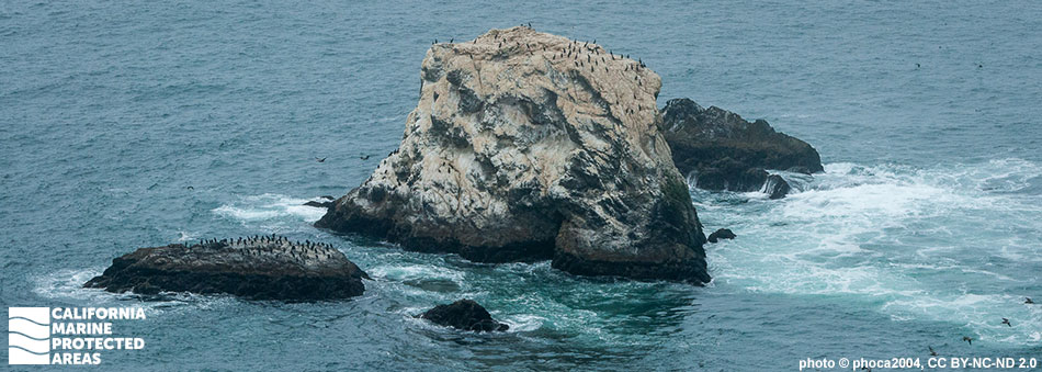
Egg (Devil's Slide) Rock to Devil’s Slide Special Closure is located about 15 miles south of the Golden Gate Bridge and two miles south of Pacifica State Beach. The special closure was established to protect seabirds that use Egg Rock and a group of small offshore sea stacks, and the area that surrounds them. It prohibits any boating or access closer than 300 feet, including transit between the rock and the mainland, year-round. While Egg Rock is closed to visitors, a trail system along old Highway 1 on the rocky promontory offers scenic vistas of the special closure.

Egg Rock is home to a breeding colony of common murres that was restored following the 1986 Apex Houston oil spill. Although it is only a small piece of protected land and sea, Egg (Devil’s Slide) Rock to Devil’s Slide Special Closure is important not only for the common murre, but also for Brandt’s cormorants that nest here, and brown pelicans, ashy storm-petrels, and other seabirds that roost in the special closure.

Regulations

Boating, access, and other specific activities are restricted. No person except employees of the California Department of Fish and Wildlife, United States Fish and Wildlife Service, U.S. Bureau of Land Management, National Oceanic and Atmospheric Administration, or United States Coast Guard during performance of their official duties, or unless permission is granted by the California Department of Fish and Wildlife, shall enter the area.

Additional restrictions related to transit exist. See the link below for details.

California Code of Regulations Title 14, Section 632(b)(64)(opens in new tab)

Quick Facts

Special Closure size: 0.05 square miles

Depth: 0 to 10 feet

Habitat composition*:

  • Rock: 0.09 square miles
  • Sand/mud: 0.02 square miles

*Habitat calculations are based on 3-dimensional area and may exceed the total MPA area listed above.

Photo Gallery

9 SEP
2022

Black oystercatcher in Egg (Devil's Slide) Rock to Devil's Slide Special Closure

0

photo © L. Flint, CC BY-NC 2.0

Showing 0 Comment

Video Gallery

California's MPA Network

About Egg (Devil's Slide) Rock to Devil's Slide Special Closure

Natural History

birds on steep oceanside rocks and cliff
Cormorants and brown pelicans at Egg (Devil's Slide) Rock to Devil's Slide Special Closure. photo © phoca2004, CC BY-NC 2.0

Egg Rock is located between the cities of Montara and Pacifica in San Mateo County. It is a sea stack, or tall island, composed of granite and sedimentary rock, sitting about 800 feet offshore of the mainland's coastal cliffs. The rock itself was likely created through a combination of erosion from waves and rain, and the frequent and sometimes intense earthquakes that occur along the many active faults in the area.

The marine ecosystem surrounding Egg Rock is predominately rocky reef, interspersed with sandy seafloor, and home to many of the same fish and invertebrate species that live throughout the Gulf of the Farallones. Larger marine animals also frequent the area with seals hauling out on the rocks, and whales passing by during migration.

During the fall, this stretch of coast is home to one of the largest populations of white sharks in the world. Many birds also live, rest, or seasonally migrate here. Egg Rock is used by breeding colonies of common murres and Brandt’s cormorants, and brown pelicans roost here as well.

Historically, both the common murre and Brandt’s cormorant bred on Egg Rock, but the populations were decimated by the 1986 Apex Houston oil spill. By 2007, however, just ten years after restoration efforts began, more than 400 breeding pairs of common murres as well as numerous cormorants had returned to the sea stack. Other common species of birds seen here include black oystercatchers, pigeon guillemots, and western gulls.

Cultural History

cormorant flying over water
Brandt's cormorant in Egg (Devil's Slide) Rock to Devil's Slide Special Closure. photo © D. Pomeroy, CC BY-NC 2.0

For centuries, Native American Tribes in California have relied on marine and coastal resources. Many Native American Tribes in California continue to regularly harvest marine resources within their ancestral territories and maintain relationships with the coast for ongoing customary uses. 

Access to Egg Rock and the surrounding shoreline is difficult, so it is unlikely to have been used much by the native Ohlone people, who inhabited the adjacent area prior to European arrival. European settlers began the development of what is now the San Francisco area to the north in the 1700s, but the Devil’s Slide section of the coast remained largely isolated for the next century.

The construction of a coastal road in 1879 and a railway in 1905 brought more settlement to the area, but both transportation routes were known to be dangerous as the area was (and is) prone to earthquakes and rockslides. Not long after opening in 1908, the railway closed in 1920 due to maintenance difficulties. The road closed in 2013, after years of erosion and mudslide burials. A tunnel was built through nearby mountains so travelers could bypass the area, and the old roadway became part of the California Coastal Trail which offers hikers, bikers, and equestrians seaside viewing access. Magnificent views of Egg (Devil's Slide) Rock to Devil's Slide Special Closure may be seen from the trail.

The history of conservation at Egg Rock began with the Apex Houston oil spill in 1986. The oil spill affected the entire Central Coast, from Point Reyes in the north, to the Farallon Islands to the west, and to Piedras Blancas in the south. Approximately 9,000 birds were killed by the oil spill, 6,300 of which belonged to Egg Rock's breeding colony of common murres, which was completely destroyed. The U.S. Fish and Wildlife Service started a project in 1996 to recolonize Egg Rock using fake murre decoys and speakers playing murre calls. The effort was a resounding success. In the first year, two breeding pairs returned to Egg Rock to nest; by 2007 more than 400 breeding pairs of common murres were nesting there.

Recreation

Brandt's cormorants on Egg Rock
Brandt's cormorants near Egg (Devil's Slide) Rock to Devil's Slide Special Closure. photo © Leslie Flint, CC BY-NC 2.0

The Egg (Devil’s Slide) Rock to Devil’s Slide Special Closure prohibits access within 300 feet around the rock and between the rock and the mainland. However, the converted roadway now known as Devil’s Slide Trail offers a 2.6-mile roundtrip route that provides visitors with spectacular views of the coastline. Travelers driving along Highway 1 can pull over into either of the two small parking lots, one on each end of the trail, and view Egg Rock and the surrounding offshore rocks from the mainland coast.

Trail users may see any number of seabirds including common murres, Brandt’s cormorants, pigeon guillemots, western gulls, pelagic cormorants, black oystercatchers, brown pelicans, and surf scoters. Those with binoculars may see marine mammals in the offshore waters, including migrating whales, harbor seals, elephant seals, and California sea lions.

Coordinates

A special closure is designated from the mean high tide line to a distance of 300 feet seaward of the mean lower low tide line of any shoreline of any of the three rocks comprising Egg (Devil's Slide) Rock, located in the vicinity of 37° 34.640′ N. lat. 122° 31.290′ W. long.; 37° 34.660′ N. lat. 122° 31.320′ W. long; and 37° 34.630′ N. lat. 122° 31.290′ W. long.; and the area bounded by the mean high tide line and straight lines connecting the following points in the order listed:

37° 34.740’ N. lat. 122° 31.080’ W. long.;
37° 34.720’ N. lat. 122° 31.310’ W. long.;
37° 34.600’ N. lat. 122° 31.330’ W. long.; and
37° 34.520’ N. lat. 122° 31.210’ W. long.

California Code of Regulations Title 14, Section 632(b)(64)

Downloads for Egg (Devil's Slide) Rock to Devil's Slide Special Closure

Map

Map of Egg (Devil's Slide) Rock to Devil's Slide Special Closure - click to enlarge in new tab

Facts, Map & Regulations

MPA fact sheet - click to enlarge in new tab