Double Cone Rock State Marine Conservation Area

hillside looking down on shoreline

Overview

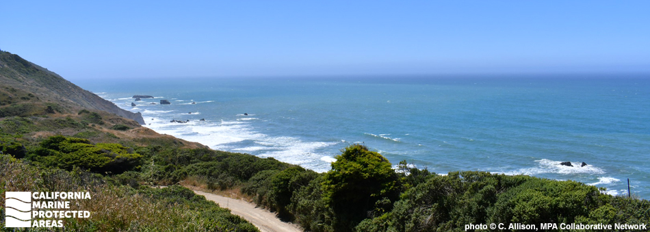
Double Cone Rock State Marine Conservation Area (SMCA) is located off a remote stretch of coastline in Mendocino County, just over 20 miles north of Fort Bragg. This marine protected area (MPA) covers roughly 18 square miles and consists of sandy beaches, rocky intertidal shores, sandy and rocky seafloor habitat, and a small kelp forest.

This SMCA was designated in 2012 to protect bottom-dwelling marine species in rocky and sandy seafloor habitats. The sandy seafloor supports flatfish such as Pacific halibut, California halibut, and rock sole. Recreational take of salmon by trolling and Dungeness crab by trap, hoop net, or hand is permitted within Double Cone Rock SMCA since these support lucrative local industries. Vizcaino Rock Special Closure, a hot spot for breeding seabirds, lies at the south end of Double Cone Rock SMCA. As native environmental stewards of this stretch of the coast, over 15 federally recognized tribes in this region are exempt from MPA regulations.

Regulations

It is unlawful to injure, damage, take, or possess any living, geological, or cultural marine resource, EXCEPT:
Recreational take of salmon by trolling and Dungeness crab by trap, hoop net or hand is allowed. Commercial take of salmon with troll fishing gear and Dungeness crab by trap is allowed. Includes take exemptions for the following tribes:

  • Big Valley Band of Pomo Indians of the Big Valley Rancheria
  • Cahto Indian Tribe of the Laytonville Rancheria
  • Coyote Valley Band of Pomo Indians
  • Elem Indian Colony of Pomo Indians of the Sulphur Bank Rancheria
  • Guidiville Rancheria
  • Habematolel Pomo of Upper Lake
  • Hopland Band of Pomo Indians of the Hopland Rancheria
  • Lower Lake Rancheria
  • Manchester Band of Pomo Indians of the Manchester-Point Arena Rancheria
  • Middletown Rancheria of Pomo Indians
  • Pinoleville Pomo Nation
  • Potter Valley Tribe
  • Redwood Valley Rancheria of Pomo Indians
  • Robinson Rancheria of Pomo Indians
  • Round Valley Indian Tribes of the Round Valley Reservation
  • Scotts Valley Band of Pomo Indians
  • Sherwood Valley Rancheria of Pomo Indians

California Code of Regulations Title 14, Section 632(b)(16)(opens in new tab)

Quick Facts

MPA size: 18.49 square miles

Shoreline span: 4.9 miles

Depth range: 0 to 391 feet

Habitat composition*:

  • Rock: 3.55 square miles
  • Sand/mud: 17.03 square miles

*Habitat calculations are based on 3-dimensional area and may exceed the total MPA area listed above.

Photo Gallery

3 OCT
2023

Amphipods at Double Cone Rock SMCA

0

photo © C. Teague, CC BY-NC 2.0

Showing 0 Comment

Video Gallery

California's MPA Network

About Double Cone Rock State Marine Conservation Area

Natural History

amphipods and sea urchin
Caprellid amphipods and a purple sea urchin at Double Cone Rock SMCA. photo by C. Belak, Humboldt State University

Clusters of rocky outcroppings are scattered along this stretch of the northern California coastline. An outcropping with two sheer-faced, jagged conical shapes a few hundred feet off Usal Beach, known as Double Cone Rock, gives this marine conservation area its name.

Many of the sea stacks along the northern California coast are derived from Franciscan mélange, a conglomeration of sandstone, shale, serpentine, and other volcanic rocks that were originally part of the oceanic plate. The rocky coastline was lifted to the surface long ago as the oceanic plate collided with the North American Plate.

This area of undeveloped, isolated coastline is known for its dramatic, rugged sea cliffs, black sand, and rocky beaches. The waters offshore teem with crab, salmon, lingcod, rockfish, California halibut, and albacore. Dungeness crab and salmon are the only marine species that may be taken in these waters, as both of those species are important to the local economy. Gray whales can be spotted just a few miles offshore as they make their annual migration. Dolphins, sea lions, and harbor seals can also be seen as they forage along this stretch of coast.

Cultural History

sea star amidst algae
Ochre sea star and coralline algae at Double Cone Rock SMCA. photo by C. Belak, Humboldt State University

For centuries, Native American Tribes in California have relied on marine and coastal resources. Many Native American Tribes in California continue to regularly harvest marine resources within their ancestral territories and maintain relationships with the coast for ongoing customary uses. The Pomo people and Coast Yuki tribe are two of the Native American groups indigenous to this northern California region.

The Coast Yuki relied on coastal resources, referring to themselves as ‘Ukoht-ontilka’, which means ‘ocean people.’ Harvesting food from the ocean was very important to local Native American Tribes, especially fishing for salmon during seasonal runs. Shellfish, including mussels and abalone, smelt, and eel were also dietary staples. When European and American settlers began arriving in the 1800s, native people were displaced or died from disease. Today, there are over 15 federally recognized tribes with ties to this area, including the Redwood Valley Rancheria of Pomo Indians and the Big Valley Band of Pomo Indians of the Big Valley Rancheria.

Following the arrival of Europeans, logging became the main industry along this stretch of the Mendocino coast. Beginning around 1850, mass quantities of the towering redwoods that defined this coastal environment were cut down, milled, and shipped out of nearby ports. Though the last big mill was shut down in 1998, remnants of the logging industry can still be seen today in remote coastal communities.

Recreation

tiny, bell-shaped jellyfish
Stalked jellyfish at Double Cone Rock SMCA. photo by C. Belak, Humboldt State University

Double Cone Rock SMCA receives relatively few visitors given its location along such a remote part of the California coast. The land adjacent to this SMCA is part of the Sinkyone Wilderness State Park and is largely undeveloped, with dense redwood forests and wooded hills dominating the terrain.

Roads are few and far between. Highway 1 is the main road that links together a few small, unincorporated communities here. To access Double Cone Rock SMCA, take Usal Road which breaks off from Highway 1 and winds north. At the mouth of Usal Creek, north of Double Cone Rock SMCA, sits Usal Campground. This isolated campground is a drive-in camp located near trailheads that offer direct beach access and a view of the SMCA. At the south end of the SMCA, you can hike to Rockport Bay to view Double Cone Rock SMCA to the north and Vizcaino Rock Special Closure to the south.


Coordinates

This area is bounded by the mean high tide line and straight lines connecting the following points in the order listed except where noted:

39o 48.500 ′ N. lat. 123o 50.713 ′ W. long.;
39o 48.500 ′ N. lat. 123o 55.875 ′ W. long.; thence southward along the three nautical mile offshore boundary to
39o 44.300 ′ N. lat. 123o 54.178 ′ W. long.; and
39o 44.300 ′ N. lat. 123o 50.055 ′ W. long.

California Code of Regulations Title 14, Section 632(b)(16)

Downloads for Double Cone Rock State Marine Conservation Area

Map

Map of Double Cone Rock State Marine Conservation Area - click to enlarge in new tab

Facts, Map & Regulations

MPA fact sheet - click to enlarge in new tab