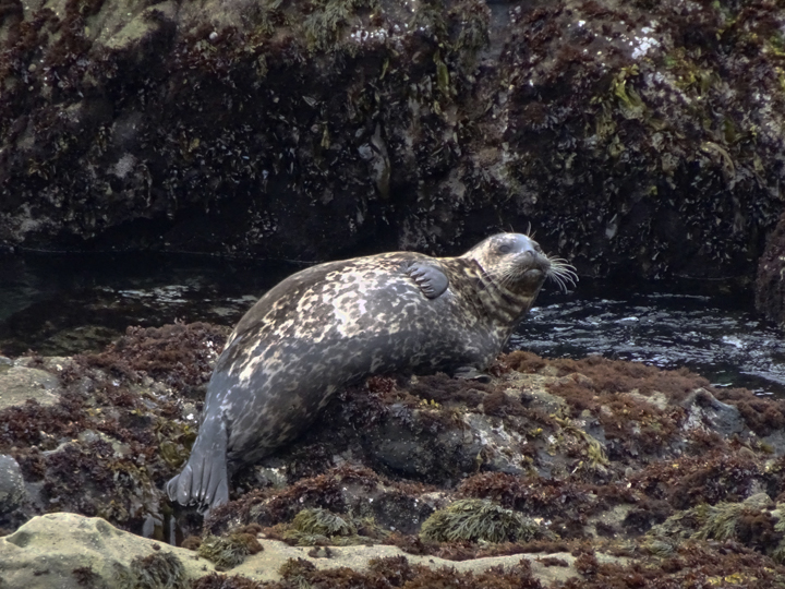
 Harbor seal at Del Mar Landing State Marine Reserve. photo © Dario, CC 1.0.
Del Mar Landing SMR includes stretches of rocky shores, small coves, nearshore reefs, and kelp forests. Sea caves at the base of the bluffs create alcoves, ledges, and outcroppings ideal for nesting seabirds. You may spot California brown pelicans roosting, pelagic cormorants building nests, and shorebirds such as black oystercatchers and wandering tattlers foraging for mussels and limpets in the tidepools.
Offshore, bull kelp and an assortment of other kelp species attach to the submerged rocky reef, rising toward the surface to create underwater forests full of life. The kelp beds are interspersed with offshore islands and sea stacks, remnants of the earlier shoreline. Blue rockfish, kelp greenling, gopher rockfish, and cabezon benefit from the kelp forest understory, and crabs, gumboot chitons, sea stars, anemones, and sponges hunt, graze, and filter the water and sediments for food on the rocky substrate.
The rocky intertidal zone at Del Mar Landing SMR teems with life, including seagrass, kelp, and numerous species of invertebrates and fish. Giant green anemones are attached to rocks in the tidepools while California mussels form large black beds that are so prolific, they can be spotted from the bluffs. Mussels are often surrounded and covered by acorn barnacles, interspersed with colorful ochre sea stars. While the mussels and barnacles are stationary, limpets, sea slugs, and snails move about the intertidal zone, grazing on the rock surfaces. Pacific harbor seals and California sea lions haul out on the rocky reef and feed on fish and invertebrates in the kelp forest.
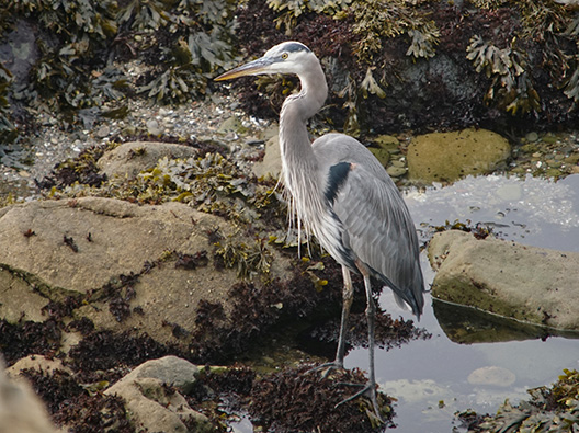 Great blue heron at Del Mar Landing State Marine Reserve. Photo © Karen & Mike, CC BY 2.0.
For centuries, Native American Tribes in California have relied on marine and coastal resources. Many Native American Tribes in California continue to regularly harvest marine resources within their ancestral territories and maintain relationships with the coast for ongoing customary uses. The land adjacent to Del Mar Landing SMR is part of the traditional territory of the Pomo, a large and diverse group of semi-nomadic people. While strong coastal winds prevented the Pomo from establishing permanent homes here, seasonal trips rewarded them with coastal resources for food and materials, including dietary staples like salmon and acorns.
Russian and native Alaskan hunters frequented the area as early as 1812, and the land was later settled by Mexicans. The Rancho German Mexican land grant, awarded in 1846, spanned from Gualala to Ocean Cove, including what is now Del Mar Landing SMR.
As the timber industry grew in Sonoma and Mendocino, doghole ports sprung up along the coast. Doghole ports, named by sailors who joked they weren't big enough for a dog to turn around in, were equipped with a network of chutes and cables for loading and unloading ships. Del Mar Landing was one of the only doghole ports without a natural cove to shield anchored ships from rough seas. In 1910, the mill at Del Mar Landing burned down, ending activity at the Del Mar Landing doghole port. However, remnants of port infrastructure are visible along the bluffs, such as protruding wooden timbers, iron eye bolts, and iron rings set into rocks.
In 1963, a Hawaiian-based developer, Oceanic Properties, purchased a ten mile stretch of Del Mar Ranch, and renamed it The Sea Ranch. Envisioned as a unique, planned community, The Sea Ranch was developed by a team of renowned architects and planners and is known for its distinctive architecture. Disagreements between The Sea Ranch and advocates of public coastal access played a key role in the establishment of the California Coastal Commission and landmark public access laws. Today, Del Mar Landing State Marine Reserve sits adjacent to The Sea Ranch and its roughly 1,300 residents.
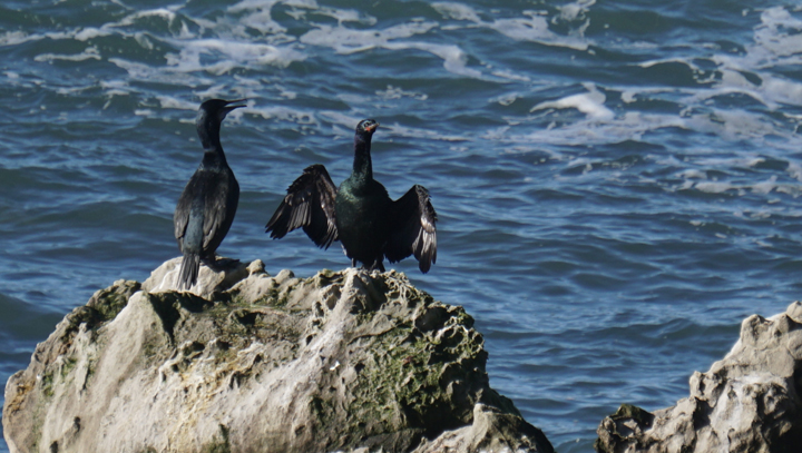 Pelagic cormorants sunning on a rock at Del Mar Landing State Marine Reserve. Photo © Karen & Mike, CC BY 2.0.
Access to Del Mar Landing SMR requires a short hike. Public access parking, maintained by Sonoma County Parks, is available in two locations, with the SMR centered between the two. The Sea Ranch is a community of private homes and Sea Ranch roads, facilities, and many of the trails are private, for use by owners, renters, and their guests only, so it is important to stay on marked trails. North of the SMR, park within Gualala Point Regional Park (for a fee) and follow the public Salal Trail to the ocean bluff. Head south on Bluff Trail for about a half mile to reach the MPA. Alternatively, south of the SMR, park for free at the Walk-On Beach public access parking lot, follow the trail to the ocean bluff, and head north on the Bluff Trail for about a quarter mile to reach the MPA.
Swimming, diving, and kayaking are all popular activities in the area near Gualala and the Gualala River. Campgrounds are located at Gualala River Redwood Park, Gualala Point Regional Park, and Anchor Bay Campground.