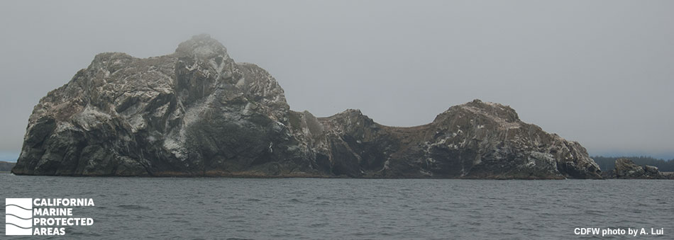
Castle Rock Special Closure

an unevenly shaped rocky island in the ocean

Overview

Castle Rock is located about a half mile off Crescent City. Rising steeply from the sea, this 14-acre isle features sheer cliffs, a pebble beach, rocky reefs, and vegetated marine terraces. With its large size and wide assortment of structural features, Castle Rock provides an ideal breeding and resting location for migratory seabirds and marine mammals, and a suitable permanent home for an abundance of other marine life. Multiple species of birds breed and rest here, including the common murre, tufted puffin, Brandt’s cormorant, pelagic cormorant, rhinoceros auklet, and Leach’s storm-petrel. Pacific harbor seals, northern elephant seals, California sea lions, and Steller sea lions haul out to rest on Castle Rock's pebble beach and rocky shoreline.

Extending 300 feet seaward and surrounding Castle Rock itself, Castle Rock Special Closure covers 0.05 square miles of ocean along the outer edges of Castle Rock. Boating is prohibited year-round within the buffer of protected waters around Castle Rock, to prevent human disturbances to the fragile wildlife communities found there.

Regulations

Boating and access are restricted. Except as permitted by federal law or emergency caused by hazardous weather, no vessel shall be operated or anchored at any time from the mean high tide line to a distance of 300 ft. seaward of the mean lower low tide line of any shoreline of Castle Rock, year round.

No person except employees of the California Department of Fish and Wildlife, United States Fish and Wildlife Service, National Oceanic and Atmospheric Administration, or United States Coast Guard during performance of their official duties, or unless permission is granted by the California Department of Fish and Wildlife, shall enter the area.

California Code of Regulations Title 14, Section 632(b)(4)(opens in new tab)

Quick Facts

Special Closure size: 0.05 square miles

Depth range: 0 to 15 feet

Habitat composition*:

  • Rock: 0.10 square miles
  • Sand/mud: 0.02 square miles

*Habitat calculations are based on 3-dimensional area and may exceed the total MPA area listed above.

Photo Gallery

26 SEP
2023

Common murres at Castle Rock Special Closure

0

photo © J. Ward, CC BY-NC 2.0

Showing 0 Comment

Video Gallery

California's MPA Network

About Castle Rock Special Closure

Natural History

hundreds of birds perched on a rocky hillside
Common murres on Castle Rock. photo © J. Ward, CC BY-NC 2.0

Castle Rock features sheer rock cliffs, rocky reefs, pebble beaches, and vegetated terraces. The island is fringed by a rich underwater environment submerged in the murky north coast waters of the Pacific Ocean. Rocky intertidal and shallow submerged reef habitats are home to invertebrates like marine worms, octopuses, anemones, and snails, which provide abundant food sources for other invertebrates and fish. Greenling, smelt, rockfish, and many other fish species in the surrounding waters are targeted by hungry seabirds and marine mammals.

Castle Rock is home to 100,000 breeding seabirds belonging to 11 different species, including storm-petrels, cormorants, gulls, auklets, and puffins. One of the largest common murre colonies on the Pacific Coast gathers at Castle Rock each year. While murres lay a single egg on bare ground, pelagic cormorants nest on steep cliffs to minimize predation, and Cassin’s auklet and rhinoceros auklet dig burrows in the dirt for their eggs, far away from the cliff edges. Castle Rock also hosts the northernmost breeding colony of northern elephant seals, a species once on the brink of extinction. Other marine mammals such as Pacific harbor seals, California sea lions, and Steller sea lions use Castle Rock as a resting location.

Cultural History

rocky island viewed through a scope
A view of Castle Rock. photo © Natalie Queall, all rights reserved

For centuries, Native American Tribes in California have relied on marine and coastal resources. Many Native American Tribes in California continue to regularly harvest marine resources within their ancestral territories and maintain relationships with the coast for ongoing customary uses. ‘Ee-nii-k’wvt is the name given to Castle Rock by the Tolowa Dee-ni’ Nation and translates to “ground-there-upon”. Tolowa Dee-ni' peoples regard Castle Rock as a culturally significant location.

In 1849 gold was discovered in California, catapulting the region into statehood. Castle Rock was claimed by the United States government around 1900. Around the same time, a 12 ft. x 12 ft. wooden cabin was built on the east end of the island and sheep were transported to and from the island by boat to graze during extreme low tides.

From 1917 to 1961, bird researchers and egg collectors visited the island to observe and gather specimens. In 1979, Castle Rock was purchased by The Nature Conservancy due to the island's critical role as a spring staging ground for almost the entire population of Aleutian cackling geese prior to their final migration to Alaskan breeding grounds. The United States Fish and Wildlife Service purchased the island from The Nature Conservancy in 1979. It is now a National Wildlife Refuge as well as a special closure within California’s MPA Network.

Recreation

rocks and islands protruding from the ocean
A view of Castle Rock. photo © C. Allison, MPA Collaborative

Castle Rock and its surrounding waters are not accessible to recreational visitors by foot or by vessel. There is a year-round restriction prohibiting access within 300 feet of the island.

Just inshore of Castle Rock is Pebble Beach, an expansive stretch of sand connecting various coves near Crescent City. Parking is available in areas along South and North Pebble Beach Drive between Battery Point and the Point St. George headland. Pebble Beach provides opportunities for beach walking, birdwatching, fishing, tidepooling, surfing, hiking, and seasonal whale watching between the months of November and April.


Coordinates

A special closure is designated from the mean high tide line to a distance of 300 feet seaward of the mean lower low tide line of any shoreline of Castle Rock, located in the vicinity of 41° 45.706' N. lat. 124° 14.949' W. long.

California Code of Regulations Title 14, Section 632(b)(4)

Downloads for Castle Rock Special Closure

Map

Map of Castle Rock Special Closure - click to enlarge in new tab

Facts, Map & Regulations

MPA fact sheet - click to enlarge in new tab