Bolsa Bay State Marine Conservation Area, and Bolsa Chica Basin State Marine Conservation Area (No-Take)

view of bay on cloudy day

Overview

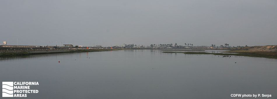
Bolsa Bay State Marine Conservation Area (SMCA) and Bolsa Chica Basin SMCA (No-Take) are adjacent marine protected areas (MPAs) located along Highway 1 in the city of Huntington Beach in Orange County. Together the MPAs cover nearly one square mile of critical estuary and salt marsh, overlapping a portion of the 1,200-acre Bolsa Chica Wetlands. The wetlands include one of the largest remaining saltwater marshes in Southern California.

Running for nearly two miles parallel to Bolsa Chica State Beach, the wetlands contain two primary habitats: a low-lying intertidal wetland that is frequently inundated by water, and a high marshy area. The tidal flats here provide important nursery habitat for young fish, as well as crabs, shrimp, and other marine invertebrates. Horn snails and crabs are common in the tidal basin. The SMCA provides trails and interpretive signs to help explore the wetlands and observe the local wildlife. Within the MPAs, American white pelicans, northern harriers, and egrets can be seen feeding year-round, and migratory waterfowl and shorebirds proliferate in the winter.

Regulations

Bolsa Bay SMCA

It is unlawful to injure, damage, take, or possess any living, geological, or cultural marine resource, EXCEPT:
Recreational take of finfish by hook-and-line from shore in designated areas is allowed. Entry permitted only on established trails, paths or other designated areas. Closed from 8 p.m. to 6 a.m. Boating, swimming, wading and diving prohibited.

California Code of Regulations Title 14, Section 632(b)(121)(opens in new tab)

Bolsa Chica Basin SMCA (No-Take)

It is unlawful to injure, damage, take, or possess any living, geological, or cultural marine resource. Take incidental to certain permitted activities may be allowed. Other restrictions may apply. See CCR T14 §632(b) for details.

California Code of Regulations Title 14, Section 632(b)(122)(opens in new tab)

Quick Facts

Bolsa Bay SMCA

MPA size: 0.07 square miles

Habitat composition*:

  • Estuary: 0.07 square miles
  • Coastal marsh: 0.70 square miles

Bolsa Chica Basin SMCA (No-Take)

MPA size: 0.70 square miles

Habitat composition*:

  • Estuary: 0.65 square miles
  • Eelgrass: 0.05 square miles
  • Coastal marsh: 2.95 square miles

*Habitat calculations are based on 3-dimensional area and may exceed the total MPA area listed above.

Photo Gallery

9 AUG
2022

Pacific glasswort in Bolsa Bay SMCA

0

photo © Diego Tamayo, CC BY-NC 2.0

Showing 0 Comment

Video Gallery

Southern California Marine Protected Area Highlights

California's MPA Network

About Bolsa Bay State Marine Conservation Area, and Bolsa Chica Basin State Marine Conservation Area (No-Take)

Natural History

two birds with beaks in the water
Marbled godwit and duck in Bolsa Bay SMCA. photo © Diane Etchison, CC BY-NC 2.0

The Bolsa Chica Wetlands were once extensive, but now represent one of the last remaining saltwater marshes south of Point Conception. The narrow Bolsa Bay SMCA is sandwiched between Highway 1 and the Lower Mesa, a part of the Bolsa Chica Ecological Reserve, designated by the California Department of Fish and Wildlife. Canary Island date palms on the Lower Mesa adjacent to Bolsa Bay SMCA serve as a nesting area for great blue herons that hunt in wetlands of the Bay and grassy areas of the Mesa.

From the trails throughout the SMCA, there are ample bird watching opportunities. Red-tailed hawks, peregrine falcons, and great horned owls soar overhead. This is also an important stop for migratory birds in North America. In the winter, western sandpipers hop along the shore, double-crested cormorants dive in the water, and snowy egrets fly overhead. Endangered species such as the Belding's savannah sparrow and California least tern can be spotted during summer months.

Within the intertidal marsh of the Bolsa Bay SMCA, daily inundations of tidal water cause fluctuating salinity, an important environmental factor. California sea hares can be spotted in the waters below the footbridge grazing the algae while stingrays swim and jellyfish drift by. During the summer months, filter-feeding animals such as sea squirts, clams, and sponges feed on the decomposing algae. Many of the marsh plants flower in summer including the tall stalks of purple and white flowering sea lavender.

Cultural History

fish and oysters in shallow water
Spotted sand bass and oysters in Bolsa Chica Basin SMCA (No-Take). Photo © Ari Boehm, CC BY-NC 2.0

For centuries, Native American Tribes in California have relied on marine and coastal resources. Many Native American Tribes in California continue to regularly harvest marine resources within their ancestral territories and maintain relationships with the coast for ongoing customary uses. The Bolsa Chica Wetlands area is within the traditional territory of the Tongva and Acjachemen peoples. These Tribes developed several specialized crafts and tools, including nets, fish hooks, and tule canoes. The canoes enabled travel offshore and access to deep water marine resources such as fish, abalone, and mussels.

The Cabrillo Expedition, led by Juan Rodríguez Cabrillo in the 1540s, was likely the first group of Europeans to explore Bolsa Bay, but Spanish settlement did not occur until the construction of Mission San Gabriel Arcángel at the foothills of the San Gabriel Mountains in 1771. The largest ever land grant in California was granted to a Spanish soldier, Manuel Perez Nieto in 1787, and included the area now known as the Bolsa Chica Wetlands.

In 1834, the rancho was subdivided into six parcels, and the wetlands of Bolsa Bay became known as Rancho Las Bolsas and Rancho Bolsa Chica. In 1895, a small portion of Rancho Bolsa Chica was sold to Los Angeles businessmen who created the Bolsa Chica Gun Club. They used this stretch of coastline as a duck hunting preserve and constructed a hunting lodge and several other buildings. Most notably, the gun club constructed a dam which separated the inner and outer Bolsa Bay, preventing direct tidal flow of the ocean. This greatly damaged the natural ecology of the area, changing the landscape from a saltwater marsh to freshwater ponds.

The 1900s saw much turnover in ownership and management of the Bolsa Chica Wetlands area. In 1920, the Standard Oil Company began leasing land from the Bolsa Chica Gun Club, although oil drilling of the lowlands did not begin until 1940. The 300-acre Bolsa Chica Ecological Reserve was created in 1970 in response to objections to a large development project. Tide gates were installed in the dam, allowing for salt water to flow again. In 1976, the group Amigos de Bolsa Chica was created and in 1990, the Bolsa Chica Conservancy was founded with the mission to educate the public about the importance of wetlands. By 2000, about 1,200 acres of the Bolsa Chica Wetlands area had been officially set aside for protection and restoration. Between 2004 and 2006, a restoration project reconstructed more than 500 acres of the Bolsa Chica lowlands to the original conditions of the 1800s.

Recreation

shallow water surrounds grassy sand flats
Wetlands within Bolsa Chica Basin SMCA (No-Take). photo © Sergei Gussev, CC BY 2.0

Located along Highway 1, these MPAs are easily accessible. There is a small parking lot southeast of the intersection of Warner and the Pacific Coast Highway, next to the Bolsa Chica Conservancy Interpretive Center. From here, visitors can access the Mesa Trail which leads to the Mesa Trail Overlook. Another small parking lot on the Pacific Coast Highway across from the entrance to Bolsa Chica State Beach leads to the 1.5 miles Loop Trail.

The three organizations involved in the conservation of Bolsa Chica - Amigos de Bolsa Chica, Bolsa Chica Conservancy, and Bolsa Chica Land Trust - all offer guided tours of the wetlands and ample volunteer opportunities.

While no take is allowed within the Bolsa Chica Basin SMCA (No-Take), the recreational take of finfish by hook-and-line is allowed in designated areas from shore in the Bolsa Bay SMCA, specifically at the fishing area next to the Bolsa Chica Conservancy Interpretive Center. In this designated area along the shoreline, anglers can try their luck at catching species such as yellowfin croaker, California scorpionfish, and spotted sand bass.

The five-mile trail system provides incredible wildlife viewing opportunities. Photography and birdwatching are especially popular, with as many as 70 different species of birds that can be spotted in one day. Across the highway, the Bolsa Chica State Beach Visitor Center features interpretive exhibits and the beach has 50 RV campsites.

Coordinates

Bolsa Bay SMCA

This area includes the waters below the mean high tide line within Bolsa Bay estuary southward of a line that approximates the Warner Avenue bridge located between the following two points:

33° 42.700' N. lat. 118° 03.633' W. long.; and
33° 42.700' N. lat. 118° 03.604' W. long.;

and northward of a line that approximates the pedestrian bridge located between the following two points:

33° 42.219' N. lat. 118° 03.167' W. long.; and
33° 42.177' N. lat. 118° 03.186' W. long.

California Code of Regulations Title 14, Section 632(b)(121)

Bolsa Chica Basin SMCA (No-Take)

This area includes the waters below the mean high tide line within the Bolsa Chica Basin estuary northeastward of the Pacific Coast Highway Bridge, approximated by a straight line between the following two points:

33° 41.028' N. lat. 118° 02.153' W. long.; and
33° 40.981' N. lat. 118° 02.109' W. long.;

and southeastward of a straight line between the following two points:

33° 42.219' N. lat. 118° 03.167' W. long.; and
33° 42.177' N. lat. 118° 03.186' W. long.

California Code of Regulations Title 14, Section 632(b)(122)

Downloads for Bolsa Bay State Marine Conservation Area

Map

Map of Bolsa Bay State Marine Conservation Area - click to enlarge in new tab

Facts, Map & Regulations

MPA fact sheet - click to enlarge in new tab

Downloads for Bolsa Chica Basin State Marine Conservation Area (No-Take)

Map

Map of Bolsa Chica Basin State Marine Conservation Area - click to enlarge in new tab

Facts, Map & Regulations

MPA fact sheet - click to enlarge in new tab