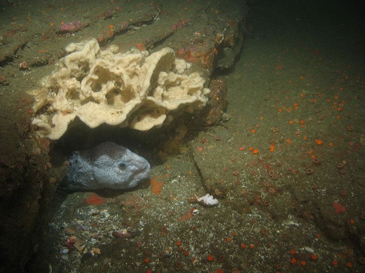
 Wolf-eel and sponge in Año Nuevo SMR. CDFW/MARE photo.
Greyhound Rock is a tombolo, an offshore rock connected to the beach by a sandspit. Like many of the coastal bluffs in Santa Cruz County, Greyhound Rock is comprised of Santa Cruz mudstone, a very common type of rock found from Año Nuevo State Park to the west side of Santa Cruz.
The SMCA contains a narrow band of tidepools filled with crabs, sea urchins, anemones, mussels, limpets, and sea stars. During low tides, the SMCA's marine terraces are populated with marine mammals that haul out on them to rest. Año Nuevo Island and protected mainland beaches provide habitat for seal and sea lion rookeries, most notably for the northern elephant seal and endangered Steller sea lion.
Elephant seals were hunted to the brink of extinction in the late 1800s, but after a remarkable conservation intervention they have recovered to nearly 200,000 individuals. These massive animals haul out on Año Nuevo’s protected beaches during winter to breed and again in spring to molt. The males compete in sometimes violent matches for control of beach territory, quite the spectacle for the lucky observer. With plentiful elephant seals, Steller sea lions, and a variety of other pinnipeds, it comes as no surprise that these MPAs are also host to a large white shark population that preys upon them.
In addition to the many large marine animals frequently found in these MPAs, more than 300 species of invertebrates, fishes, and seabirds are also found throughout the cold ocean waters. Anemones, mussels, and barnacles line the rocky shores, where small pools of ocean water hide fish like gobies and sculpins. Rockfish, sea cucumbers, bat stars, and gorgonians are common throughout the deep submerged reefs and the kelp forests closer to shore. Coho salmon and steelhead trout, once abundant along the coast, may be making a modest recovery in Waddell and Scott creeks adjacent to these MPAs.
With ample offshore rocks and stretches of undeveloped coastline, the MPAs provide abundant feeding, resting, and breeding areas for migratory and resident birds. While black oystercatchers, plovers, willets, gulls, and godwits hunt onshore by probing the sand for buried prey or picking through the tidepools, brown pelicans, cormorants, and murres dive in these abundant waters, feasting on schools of baitfish.
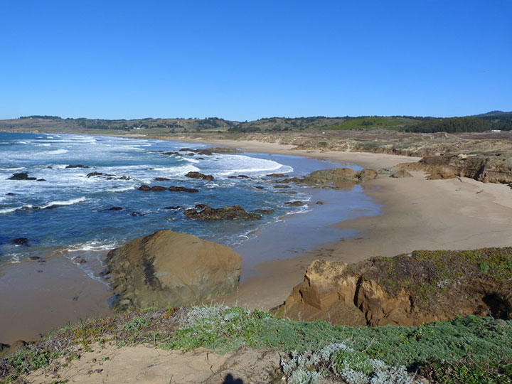 Gazos Creek State Beach just north of Año Nuevo SMR. NOAA photo.
For centuries, Native American Tribes in California have relied on marine and coastal resources. Many Native American Tribes in California continue to regularly harvest marine resources within their ancestral territories and maintain relationships with the coast for ongoing customary uses. The area that includes these MPAs was inhabited by the Ohlone people, who resided here long before Europeans arrived. The Ohlone used purple olive snail shells, which commonly washed ashore, as currency as well as in jewelry. Today, the Ohlone maintain a presence along the Central Coast, with individuals living throughout the region.
This stretch of coastline has been a thriving commercial and economic center for centuries, historically teeming with marine resources. Scientists even discovered the remains of a 15-million-year-old baleen whale nearby.
The first European account of the Año Nuevo area was written on January 3, 1603 when the Spanish explorer Sebastian Vizcaino sailed past Año Nuevo Point and noted it in his journal. He named it Punta del Año Nuevo in honor of the new year. Mission Santa Cruz was founded nearby in 1791 and likely brought about an increase in fur hunting and fishing along the coast, while the hillsides around Año Nuevo Point were used for cattle grazing. After a series of shipwrecks along the treacherous coastline in the mid-1800s, a foghorn (1872) and lighthouse (1890) were built on Año Nuevo Island. The light station was operational until 1948 when it was replaced by an offshore buoy when maintenance of the facility was deemed too expensive.
In 1969, Pacific Gas and Electric leased nearby land to construct a nuclear power plant, but this effort was halted when erosion of a cliff at nearby Año Nuevo Point exposed an active fault line. The area surrounding Año Nuevo Point was owned by several farmers and ranchers until 1971 when most of the land was bought by the State of California. Today, Año Nuevo is a jewel in California's coastal conservation system because of its natural beauty, recreational opportunities, and scientific utility. While most of the light station buildings on the island have eroded into the sea, a small research facility studying seals, sea lions, sharks, and seabirds operates from the remaining buildings.
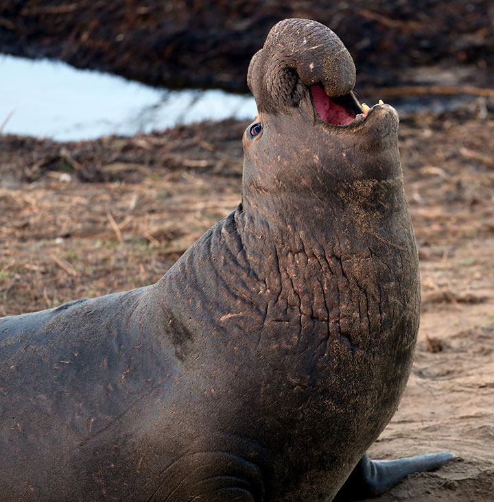 Northern elephant seal in Año Nuevo SMR. photo © T. Wise, CC BY 2.0.
There are numerous beaches at both the SMR and SMCA that invite visitors to spend the day taking in the wonder of the Central Coast and the unique geology and biology it contains. Cove Beach within Año Nuevo SMR is famous for its geologic formations and occasionally elephant seals will haul ashore there. The SMR also offers beach access at Gazos Creek and Waddell Beach, popular areas for kitesurfing. There is parking at Greyhound Rock, and the beach and rock are worth the steep walk down.
At low tide, visitors can walk to Greyhound Rock for a better look. Most of this stretch of coast is dominated by steep bluffs with few access points. At Greyhound Rock County Park, visitors have access to picnic tables, benches, and wheelchair-accessible platforms for stunning views of the surrounding cliffs and ocean. Recreational anglers can fish using hook-and-line for finfish from shore, and the take of giant kelp, salmon, and market squid is allowed within this SMCA as well. All take is prohibited in Año Nuevo SMR.
Along the MPAs' coastline, visitors can go tidepooling, embrace the cold California waters during a swim, picnic and spend a day on the beach, or even brave the surf breaks. At the entrance to Año Nuevo State Park, adjacent to Año Nuevo SMR, a large visitor center provides historical and natural history information, beach wheelchairs are available for all guests to fully enjoy the coast, docent-led and self-guided tours offer elephant seal viewings, and a gift shop and restrooms are available.
Coordinates
Año Nuevo SMR
This area is bounded by the mean high tide line and a distance of 200 feet seaward of mean lower low water between the following two points:
37° 10.000′ N. lat. 122° 21.800′ W. long; and
37° 08.725′ N. lat. 122° 21.000′ W. long.
The area then continues southward bounded by the mean high tide line and straight lines connecting the following points in the order listed:
37° 08.725′ N. lat. 122° 21.000′ W. long.;
37° 04.700′ N. lat. 122° 21.000′ W. long.;
37° 04.700′ N. lat. 122° 16.062′ W. long.; and
37° 04.742′ N. lat. 122° 16.026′ W. long.
California Code of Regulations Title 14, Section 632(b)(67)
Greyhound Rock SMCA
This area is bounded by the mean high tide line, the three nautical mile offshore boundary and straight lines connecting the following points in the order listed except where noted:
37° 04.742′ N. lat. 122° 16.026′ W. long.;
37° 04.700′ N. lat. 122° 16.062′ W. long.;
37° 04.700′ N. lat. 122° 21.000′ W. long.;
37° 03.520′ N. lat. 122° 21.000′ W. long.; thence southward along the three nautical mile offshore boundary to
37° 02.570′ N. lat. 122° 18.963′ W. long.; and
37° 02.570′ N. lat. 122° 13.989′ W. long.
California Code of Regulations Title 14, Section 632(b)(68)