Anacapa Island State Marine Reserve / Federal Marine Reserve / State Marine Conservation Area / Federal Marine Conservation Area / Special Closure

ocean with distant cliffs

Overview

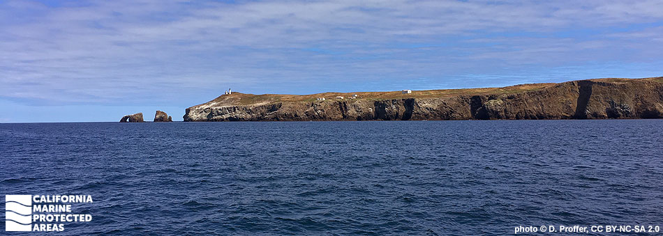
Anacapa Island is the Channel Island situated closest to the mainland, just 12 miles from Oxnard Harbor. The island is really three large islets named East, Middle, and West Anacapa that are situated more or less end-to-end like beads on a string. Together these islets make up Anacapa Island, which is nearly five miles long. The rugged island features wave-eroded volcanic shores, towering sea cliffs, caves, and natural bridges, including the 40-foot-high Arch Rock, an iconic symbol of Channel Islands National Park.

On the northern side of Anacapa Island are four marine protected areas (MPAs) known as Anacapa Island State Marine Reserve (SMR), the federal Anacapa Island Marine Reserve (FMR), Anacapa Island State Marine Conservation Area (SMCA) and the federal Anacapa Island Marine Conservation Area (FMCA), along with Anacapa Island Special Closure, which encircles the entire island.

Anacapa Island SMR encompasses more than 11½ square miles of state waters, and Anacapa Island SMCA over seven square miles. The SMR and SMCA protect sandy beaches, extensive rocky shores, surfgrass beds, kelp forests, and deep offshore sand and rocky seafloor to depths greater than 700 feet and 450 feet, respectively. Where the SMR and SMCA end at three nautical miles from shore, the FMR and FMCA continue farther offshore to the boundary of the Channels Islands National Marine Sanctuary.

Anacapa Island Special Closure surrounds all three of the islets and overlaps a portion of both the SMR and the SMCA. The special closure covers a little more than one square mile, and its main purpose is to protect breeding brown pelicans and their fledglings from human disturbance. The special closure includes a brown pelican fledgling area that is closed annually from January 1 to October 31.

Special closures are designed to minimize disturbance of seabirds and marine mammals by restricting boating and access, seasonally or year-round. This special closure prohibits the use of nets and traps in waters less than 20 feet deep, and seasonally bans boating activity and access in waters within the brown pelican fledgeling area.

Species protected within the lush kelp forests spanning the MPAs and special closure include: California sheephead, garibaldi, bat rays, moray eels, horn sharks, leopard sharks, California sea lions, harbor seals, sea stars, kelp bass, sheep crab, brightly colored nudibranchs (sea slugs), and giant sea bass, among many others. Onshore, the rocky cliffs are surrounded by the special closure, which limits access to protect one of the world’s largest breeding colonies of California brown pelicans.

Regulations

Anacapa Island SMR

It is unlawful to injure, damage, take, or possess any living, geological, or cultural marine resource.

California Code of Regulations Title 14, Section 632(b)(113)(opens in new tab)

Note: The state and federal marine reserves share identical regulations.

Anacapa Island SMCA

It is unlawful to injure, damage, take, or possess any living, geological, or cultural marine resource, EXCEPT:

Recreational take of lobster and pelagic finfish (northern anchovy, barracudas, billfishes, dorado (dolphinfish), Pacific herring, jack mackerel, Pacific mackerel, salmon, Pacific sardine, blue shark, salmon shark, shortfin mako shark, thresher shark, swordfish, tunas, Pacific bonito, and yellowtail) is allowed. Commercial take of lobster is allowed. Includes take exemptions for the following tribe:

  • Santa Ynez Band of Chumash Indians

California Code of Regulations Title 14, Section 632(b)(112)(opens in new tab)

Note: The state and federal marine conservation areas share identical regulations.

Anacapa Island Special Closure

No net or trap may be set in waters less than 20 ft deep off Anacapa Island.

20 fm (120 ft) brown pelican fledgling area closed Jan 1-Oct 31. No person except employees of the California Department of Fish and Wildlife or the National Park Service during the performance of their official duties shall enter this area during the closure period. See CCR T14 §632(b) (link below) for details.

California Code of Regulations Title 14, Section 632(b)(111)(opens in new tab)

Quick Facts

These facts are for the state marine reserve, state marine conservation area, and special closure only.

Anacapa Island SMR

MPA size: 11.55 square miles

Shoreline span: 3.1 miles

Depth range: 0 to 709 feet

Habitat composition*:

  • Rock: 0.38 square miles
  • Sand/mud: 11.15 square miles

Anacapa Island SMCA

MPA size: 7.30 square miles

Shoreline span: 2.2 miles

Depth range: 0 to 490 feet

Habitat composition*:

  • Rock: 0.14 square miles
  • Sand/mud: 6.78 square miles

Anacapa Island Special Closure

Special Closure size: 1.03 square miles

Depth range: 0 to 124 feet

Habitat composition*:

  • Rock: 0.44 square miles
  • Sand/mud: 0.53 square miles

*Habitat calculations are based on 3-dimensional area and may exceed the total MPA area listed above.

Photo Gallery

16 AUG
2022

Stearns' aeolid at the SMR

0

photo © D. Klug, CC BY-NC 2.0

Showing 0 Comment

Video Gallery

Anacapa Island State Marine Reserve

Southern California Marine Protected Area Highlights


California's MPA Network

About Anacapa Island State Marine Reserve / Federal Marine Reserve / State Marine Conservation Area / Federal Marine Conservation Area / Special Closure

Natural History

California sheephead in kelp forest
Male California sheephead in kelp forest at Anacapa Island Special Closure. photo © R. Ling, CC BY-NC-ND 2.0

Some call the Channel Islands the “Galapagos of North America” due to the incredible abundance and diversity of life on and around the islands. Within the Anacapa Island MPAs, tidepools and rich kelp forests provide visitors with the opportunity to observe local marine life. The kelp forests are filled with blacksmith, opaleye, kelp bass, señorita, black perch, and small schooling fish. California spiny lobster and sheep crab hide in rocky crevices while bat rays, leopard sharks, and giant sea bass cruise through as transient visitors.

California sheephead, a carnivore often seen in the area, possess large teeth that allow them to eat a variety of hard-shelled invertebrates such as crabs, clams, and urchins. As predators near the top of the food chain, California sheephead play an important role in maintaining the natural balance of the kelp forest.

The coastal cliffs afford an ideal refuge for the thousands of seabirds that nest in the rocky crags. Few predators can access eggs and chicks in these remote havens. The steep cliffs of West Anacapa are home to the world’s largest breeding colonies of two bird species: California brown pelicans and western gulls. The rocky, isolated shores also provide resting and breeding areas for California sea lions and harbor seals. The raucous barking of sea lions can be heard from almost anywhere on the island.

Cultural History

cove of blue-green water surrounded by steep rock cliffs
Cathedral Cove at Anacapa Island. photo © Open minded in Alabama, CC BY 2.0

For centuries, Native American Tribes in California have relied on marine and coastal resources. Many Native American Tribes in California continue to regularly harvest marine resources within their ancestral territories and maintain relationships with the coast for ongoing customary uses. The Channel Islands have a rich human history with many shell midden sites serving as remnants of early inhabitants.

Traditionally home to the Chumash, Anacapa Island was named Ennepah, meaning deception or mirage, because it appeared to change shape in the fog and afternoon heat. The island was likely only inhabited seasonally for fishing and other activities, due to a lack of reliable fresh water. The Chumash used the tomol, a traditional redwood plank canoe, to travel between the islands and mainland, and throughout extensive West Coast trade networks.

The first recorded instance of European exploration of Anacapa dates to 1521, when Juan Rodriguez Cabrillo landed on the island. More Spaniards arrived throughout the 17th century, along with Russian fur traders and explorers seeking to exploit the area's rich marine resources. During the 1900s, the island was home to a light station with a fog signal building, a water tank, and keeper’s quarters. In 1938, President Franklin D. Roosevelt signed a proclamation designating Anacapa and Santa Barbara islands as the Channel Islands National Monument. In the last half of the 20th century, landowners began selling parcels of land on the islands to The Nature Conservancy and the National Park Service. Now part of the Channel Islands National Park, the island is largely free of non-native domesticated farm animals, plants, and rats, and the island's native foxes, nesting seabirds, giant scrub jays, and plants are becoming more prevalent as the ecosystem returns to its natural state.

In 1980, Channel Islands National Park was established, replacing the Channel Islands National Monument and protecting Santa Rosa, Santa Cruz, and San Miguel islands in addition to Anacapa and Santa Barbara islands. The Channel Islands National Marine Sanctuary was established in 1980 as well, protecting 1,470 square miles of ocean encompassing waters up to six nautical miles offshore around each of the five islands.

Recreation

side of cliff with rocky beach and water at the bottom
Frenchy's Cove Beach, Anacapa Island. photo © R. Schwemmer/NOAA

Decades of protection have made Anacapa Island MPAs a spectacular destination for any marine enthusiast. The island is reachable by boat, and the MPAs can be explored by kayakers, divers, snorkelers, and swimmers. Kayakers can experience unique sea caves and pass through the iconic Arch Rock. Divers can explore many popular dive sites with depths ranging from 50 feet to 120 feet, and visibility averaging 30 feet to 80 feet.

The National Park Service authorized the concessionaire Island Packers to run regular trips to Anacapa Island, with boats departing from Ventura and Oxnard. The trip is about an hour long, unless the boat comes across whales migrating through the Santa Barbara Channel. Since this is a prime whale migration route, vessels will slow down to avoid striking whales. Visitors should bring sun protection, water, and a hat due to lack of shade and amenities on the island. No take of any marine resource is permitted within the SMR and FMR, but California spiny lobster and pelagic finfish may be taken recreationally within the SMCA and FMCA.

Coordinates

Anacapa Island SMR / FMR

This area is bounded by the mean high tide line and straight lines connecting the following points in the order listed:

34o 00.411′ N. lat. 119o 24.600′ W. long.;
34o 04.998′ N. lat. 119o 24.600′ W. long.;
34o 04.998′ N. lat. 119o 21.400′ W. long.;
34o 01.000′ N. lat. 119o 21.400′ W. long.; and
34o 00.960′ N. lat. 119o 21.463′ W. long.

Note: This area includes Anacapa Island State Marine Reserve and the adjoining federal Anacapa Island Marine Reserve. Coordinates are provided for outer boundaries of the joined state and federal areas.

The state reserve and federal reserve share identical regulations. For state reserve boundaries only, see California Code of Regulations Title 14, Section 632(opens in new tab). For federal reserve boundaries only, see Code of Federal Regulations, Federal Register 15 Part 922 and 50 CFR Part 660.

Anacapa Island SMCA / FMCA

This area is bounded by the mean high tide line and straight lines connecting the following points in the order listed:

34o 00.828′ N. lat. 119o 26.623′ W. long.;
34o 00.800′ N. lat. 119o 26.700′ W. long.;
34o 04.998′ N. lat. 119o 26.700′ W. long.;
34o 04.998′ N. lat. 119o 24.600′ W. long.; and
34o 00.411′ N. lat. 119o 24.600′ W. long.

Note: This area includes Anacapa Island State Marine Conservation Area and the adjoining federal Anacapa Island Marine Conservation Area. Coordinates are provided for outer boundaries of the joined state and federal areas.

The state reserve and federal reserve share identical regulations. For state reserve boundaries only, see California Code of Regulations Title 14, Section 632(opens in new tab). For federal reserve boundaries only, see Code of Federal Regulations, Federal Register 15 Part 922 and 50 CFR Part 660.

Anacapa Island Special Closure

No net or trap may be used in waters less than 20 feet deep off the Anacapa Islands commonly referred to as Anacapa Island.

A brown pelican fledgling area is designated from the mean high tide mark seaward to a water depth of 20 fathoms (120 feet) on the north side of West Anacapa Island between a line extending 000o True off Portuguese Rock (34o 00.910′ N. lat. 119o 25.260′ W. long.) to a line extending 000o True off the western edge of Frenchy's Cove (34o 00.411′ N. lat. 119o 24.600′ W. long.), a distance of approximately 4,000 feet. 

California Code of Regulations Title 14, Section 632(b)(111)

Anacapa Island State Marine Reserve

Map

Map of Anacapa Island State Marine Reserve and the federal Anacapa Island Marine Reserve - link opens in new window

Facts, Map & Regulations

MPA fact sheet - click to enlarge in new tab

Anacapa Island State Marine Conservation Area / Federal Marine Conservation Area

Map

Map of Anacapa Island State Marine Conservation Area - link opens in new window

Facts, Map & Regulations

MPA fact sheet - click to enlarge in new tab

Anacapa Island Special Closure

Map

Map of Anacapa Island Special Closure - link opens in new window

Facts, Map & Regulations

MPA fact sheet - click to enlarge in new tab