Drone images helped document damages and clean-up during the 2019 oil spill at Cymric Oil Field near Bakersfield
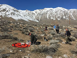
CDFW drone pilots use foldable landing pads that work on multiple surface types—here during a drone mission in Inyo County
In March 2019, there was late winter flooding at the Yolo Bypass Wildlife Area in Yolo County near Davis. Wildlife area supervisor Joe Hobbs wanted to check a series of old railroad trestle mounds to make sure there was no wildlife stranded there. In previous years when there had been flooding, staff went out on a boat to check the trestle mounds. But that approach had downsides: From a boat, it could be difficult to see exactly what was on the mounds, and the sound of the boat’s motor could potentially spook the animals.
Hobbs saw an opportunity to utilize the California Department of Fish and Wildlife’s (CDFW) drone program, a service offered by CDFW’s Geographic Information Systems (GIS) Unit within the Biogeographic Data Branch. He submitted a project request which was ultimately granted.
Drone footage showed two deer on one of the trestle mounds. A CDFW biologist did an assessment and concluded that the water was receding quickly, and the deer were not at risk of being stranded.
“The drone was a great tool for getting the information we needed without causing stress to wildlife,” said Hobbs. “It was quiet and safe and gave us a view of the trestle mounds that we couldn’t get from the ground or in a boat.”
CDFW’s drone program got its start in the early 2010s as GIS Program Manager Steve Goldman and others on the GIS team saw the technology becoming more affordable and useful. In 2014, Goldman put together a dedicated team within the GIS Unit to research policy and best practices. The program officially launched in 2016 when it received its Federal Aviation Administration authorization to fly.
“Drones are very useful for natural resource management because they provide high-resolution aerial imagery and documentation of conditions on the ground in a timely, safe and cost-effective manner that is repeatable,” said Goldman, who also serves as CDFW’s Unmanned Aircraft System (UAS) Coordinator.
Here are a few examples of CDFW drone missions:
- In 2017, a drone was used to help scientists conduct a bighorn sheep population count outside of Bishop in Inyo County
- Drone footage helped scientists survey portions of the America River in 2016 to find salmon redds, nests created by salmon in riverbeds where females lay their eggs.
- As a permitting agency for legal cannabis grows in California, CDFW advises property owners on how to mitigate environmental damage. In 2019, the department used drone footage to assist the buyer of a cannabis property with assessing erosion damage caused by the previous property owner.
- CDFW has historically partnered with other agencies to do pelican population counts using airplanes over the Tule Lake Wildlife Refuge, a national refuge near the Oregon border. In 2018, CDFW experimented with doing counts using drones to see if results could be achieved more safely and efficiently. Staff found that drones took higher quality images and could potentially yield more accurate counts. Staff also used the mission to assess the disturbance effect of drones and found no disturbance to wildlife.
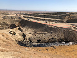
- CDFW’s Office of Spill Prevention and Response (OSPR) used drone footage in 2019 to document clean-up efforts in the nearly 800,000-gallon oil spill at Cymric Oil Field near Bakersfield. In March 2020, OSPR utilized drone footage to document clean-up efforts at a tanker truck spill in the Cuyama River in Santa Barbara County.
Because CDFW’s mission is managing the state’s natural resources, the drone program puts considerable focus on minimizing the risk of wildlife disturbance. Before each mission, program staff consult with a biologist to assess the risk of disturbance. If there is any appreciable risk, a biologist accompanies staff on the mission to serve as a wildlife observer. CDFW’s drone program also has a working group to research and catalog disturbance effects by wildlife species. The group’s goal is to minimize wildlife disturbances and develop best practices.
CDFW drone pilots have been fortunate enough to not have any major conflicts with wildlife. But there was one close call. In 2018, while on a training flight at the Yolo Bypass Wildlife Area, a raptor appeared to take interest in the drone. In these situations, pilots are trained to ascend above the bird to get away. Drones can ascend faster than birds of prey can and descend rather slowly.
“The pilot noticed the raptor’s interest early, and at one point the raptor started to come at the drone. The pilot did exactly what he was trained to do – he ascended and got out of the raptor’s way. It wasn’t a dramatic incident, but it did validate our procedures and protocol,” said Goldman.
CDFW has a fleet of 25 drones flown by 14 certified pilots. Additionally, 20 staff are working toward their drone certifications. The current growth is primarily within OSPR and within the Cannabis Lands Program. Certified staff flew 100 missions in 2019. Since the program’s launch, staff have amassed more than 1,800 flights and 300 plus hours of airtime.
“We think we’ve only started to skim the surface of what’s possible with drones. We are excited to continue working with staff to find those opportunities to support our mission,” said Goldman.
Only staff certified through the CDFW’s UAS program are authorized to operate a drone for department work. No personal drones may be used for department work.
###
CDFW Photos. Top Photo: Image from a drone mission at Sheepy Lake in Siskiyou County
Media Contact:
Ken Paglia, CDFW Communications, (916) 825-7120