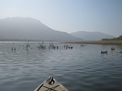
Brush habitats were created and put into Lake Perris to provide fish with habitat to feed and reproduce. The habitats will be completely submersed when the lake is filled to capacity.
The exposed lakebed gave CDFW fisheries biologists the opportunity to safely construct different kinds of habitat for the fish in Lake Perris.
Rock Reefs and Spawning gravel areas have been created and placed in more than 100 places around Lake Perris that will be utilized once the lake is returned to full capacity.
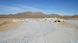
Rock Reefs constructed along the shore of Lake Perris, most about 1,000 square feet provide cover for juvenile fish and forage species.
135 Pipe Caves were constructed from PVC pipe and will provide spawning habitat for catfish.
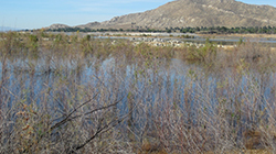
Biologists created about 1,500 brush habitats in hundreds of locations on the banks of Lake Perris and in accessible locations further into the lake.
Biologists created about 1,500 brush habitats in hundreds of locations on the banks of Lake Perris and in accessible locations further into the lake.
More than a decade ago, Southern California freshwater anglers were disappointed to see a tried-and-true fishing spot dramatically affected by an emergency lake drawdown. Due to seismic concerns with the Perris Dam, California Department of Water Resources (DWR) officials deemed it necessary to reduce the water level at Lake Perris near Riverside by several thousands of acre-feet.
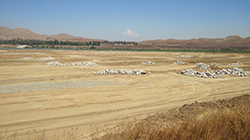
The drawdown exposed about 25 feet of bank around the perimeter of the lake. Since water was not going to be available for years while the dam was assessed and repaired, CDFW embarked upon a fisheries habitat mitigation project (funded by DWR) to create new fish habitat in the remaining water and the now exposed lakebed.
The project had two phases. The first was to immediately create fisheries habitat in the drawn-down portion of the lake in order to maximize use of the remaining water. The second was to build new habitats on the temporarily exposed areas, with the hope of benefitting both sport-fish species and anglers when the lake is eventually refilled.
After 12 years, both phases are nearly completed.
After the initial water level reduction, teams from CDFW and DWR began working to prevent the immediate collapse of the lake’s fishery. The initial work, which took three years, involved the creation and placement of about 400 fish habitats made of recycled Christmas trees and citrus limbs. The man-made shelters ensured the fish would have places to hide and reproduce.
After the initial triage, CDFW biologists began to place additional habitats into the remaining water of Lake Perris. These habitats, made of thousands of tree trunks, citrus limbs and whole tree stumps would eventually give the lake’s fish an additional 1,500 refuges for safety.
The citrus limbs were drilled with a ½” hole in the base and multiple limbs were tied together as compactly as possible and attached to a concrete block with polypropylene ropes to weigh them down. They were then placed strategically in different parts of the lake. These citrus habitats should provide cover for the warm water fish for at least 10 - 15 years.
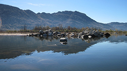
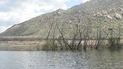
Due to their bulk, increased buoyancy and weight, the single tree stumps were placed individually around the lake and weighted down with concrete blocks to keep them anchored.
Because the lake will be refilled to capacity once dam repairs are complete, it is important that the scientists are able to carefully track each habitat location. They worked in quadrants, placing 20 - 60 bundles into each to create “communities.” The grouped communities increase localized productivity of the warm water fish native to the lake and contribute to maintaining the warm water fisheries while the lake is in its reduced capacity. Each of the quadrant’s corners was marked with GPS, enabling scientists to record and monitor data specific to each location.
The second phase of the project was the implementation of a Fishery Habitat Plan for the exposed lakebed above the drawn-down area. The implementation of the plan is a requirement of the Lake and Streambed Alteration Agreement between CDFW and DWR.
As with the below-water work that had already been completed, CDFW scientists carefully planned what kinds of habitat to create, what materials to use and where to place them in the open, exposed lakebed in order to provide the best environments for fish when the lake was fully restored. Areas were selected for habitat placement based on accessibility, proximity to existing natural habitat directly affected by the water reduction, avoidance of areas utilized for construction activities, distance from swimming areas and consideration of boating hazards.
Multiple types of habitats were designed and installed in Lake Perris, including:
- Brush habitats. Similar to the citrus branch habitats already placed in phase one, these brush habitats add to the terrestrial vegetation growth that has thrived in the lakebed since initial triage efforts began in 2006.
- Pipe caves constructed from 12” diameter PVC pipes. Approximately 4 feet long and capped at one end with concrete, these will provide spawning habitat for catfish that was lost when the lake was drawn down. A total of 135 pipe caves were placed around the rock reefs and terrestrial vegetation and will allow the young catfish to disperse into favored rearing habitat.
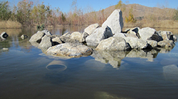
- Rock reefs were created from 226 dump truck loads of material stockpiled by DWR from a nearby rock quarry. These rock piles cover about 110,000 square feet of the lakebed -- about the size of two football fields. Staff created 109 rock reefs, each about 1,000 square feet (about the size of an average home lot). These provide cover for juvenile fish and forage species (such as crayfish) as well as spawning habitat and foraging areas for adult fish. Their placement is designed to allow fish to transition from deeper waters to shallower waters -- and vice-versa -- when the lake returns to normal operating levels.
- Spawning gravel areas. Thirty of these were created from suitable bottom composition for sunfish, bass, bluegill, etc. to spawn on and around. Almost 200,000 square feet of gravel bed habitat are now in the shallowest areas of the lake, adjacent to rock reefs or terrestrial vegetation that will be covered once the lake refills.
After years of cooperative work Lake Perris is nearly ready to be refilled and with the thousands of new and improved habitats local anglers will be shouting “fish on” for decades to come.
CDFW Photos. Top Photo: Citrus tree stumps, weighted down with concrete blocks to keep them anchored were placed individually around Lake Perris to create small habitats called communities.
# # #