Science Spotlight

rss
  • September 29, 2017

sunset paints clouds coral, in a blue sky over a flooded plain
a picnic table is lodged 20 feet high in a four-trunked tree on a plain that was recently flooded
Eight teenagers work around a picnic table covered in green plants
Five teenagers plant seedlings in cups atop a picnic table
a row of 11 trays full of green plant seedlings in a nursery setting

CDFW’s Yolo Bypass Wildlife Area serves two critical – but sometimes competing – needs.

The 16,670 acres of riparian and agricultural habitat in Yolo County provide a refuge and an all-you-can-eat buffet for migratory waterfowl and resident wildlife to the west of Sacramento and the increasingly urbanized surrounding communities.

The wildlife area is also a key cog in the Sacramento region’s flood control system. In wet years, the vast flood plain accommodates massive water diversions from the nearby Sacramento, Feather and Yuba river systems to prevent flooding in populated areas and to relieve pressure on strained river levees.

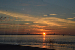
With the drought-busting rains and snow received last winter, the wildlife area resembled an inland ocean for the thousands of daily commuters traveling the Interstate-80 Yolo Causeway, which crosses the northern edge of the wildlife area. The floodwaters stretched as far as the eye could see, reaching depths of 20 feet in some places, and submerging almost every natural feature underneath. The consequences were dire for wildlife unable to escape.

Pheasants, deer, raccoons, and small rodents of all kinds were among the victims. Some were overcome by the rising water, some starved while waiting out the floodwaters in trees or isolated patches of high ground, others were picked off by predators stalking the water line for fleeing prey.

As a result, efforts are now underway to help the area’s wildlife survive future flooding. The Yolo County Resource Conservation District has secured almost $700,000 in Proposition 1 state water project funds to build two wildlife escape habitat corridors and a demonstration garden over the next four years. The project includes partnerships with CDFW, Yolo Basin Foundation, Center for Land-Based Learning, Putah Creek Council, the United States Department of Agriculture’s Natural Resources Conservation Service and Point Blue Conservation Science.

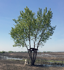
The demonstration garden will serve as an educational component for visitors near the wildlife area’s entrance. Two other corridors in the southern end of the wildlife area will stretch more than 5 miles total and include 22 acres of native grass seeding for nesting and cover. The corridors will run parallel to the Putah Creek channel, which is the only existing natural escape route now on the refuge.

“These corridors are basically like wildlife roads,” said Jeffrey Stoddard, the Yolo Bypass Wildlife Area manager for CDFW.

The floodwaters advance slowly enough that even the smallest animals can escape, Stoddard explained, provided they head in the right direction and don’t get exposed to predators along the way.

“We have blocks of escape habitat now, but we will be creating connectivity, moving animals from the east side that is deeper to the west side that is higher ground,” he said.

The corridors will consist of a mix of flood-tolerant native shrubs, grasses and forbs that will provide escape routes to high ground, protection from predators, food, and good habitat year-round.

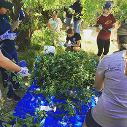
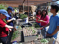
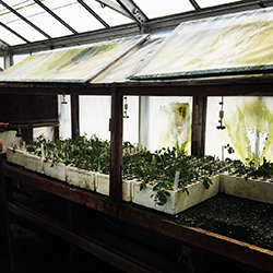
The corridor work began in June with Putah Creek Council student interns collecting wild rose, red stem dogwood and coyote brush clippings for propagating and use as plant stock for the wildlife corridors.

Photos courtesy of CDFW, the Putah Creek Council and the Yolo County Resource Conservation District. Students pictured are interns from the Putah Creek Council’s One Creek Restoration Internship program.

Categories: General
  • September 21, 2017

CDFW Seasonal Aid Katie Schroyer determines the age of a dove by examining its wing

light brown mourning dove held humanely in someone's hand
A banded mourning dove at a CDFW trap site in northern California

a woman's hand spreads a mourning dove's wing above a notebook
Age and sex data are recorded before the bird is banded and released.

a wire mesh bitd trap, approximately ten-by-seven-by-seven feet, in what looks like a barnyard
A large kennel trap can catch more than 30 birds at a time.

As the second half of California’s split dove season kicks off, dove hunters may put more than birds in their bags. They may harvest a bird with a band on its right leg – thus getting an opportunity to contribute important data that will help guide future management efforts.

Since 2003, California has been an active partner in a nationwide assessment of mourning dove populations. California is one of 39 states that currently participate in dove banding. During the months of July and August, trained biologists and volunteers trap and band doves throughout the state. The banding of migratory birds requires a Master Banding Permit issued upon approval of a study application by the U.S. Geological Survey. All banders must pass an annual training to participate and are then issued a sub-permit.

Mourning doves are so widely distributed that banding operations can be – and are – located almost anywhere, from rural locations to urban backyards. Larger operations located on Wildlife Areas, ranches and open desert sites may employ the use of a large kennel trap capable of trapping 30 or more birds at a time, while smaller operations (“backyard banders”) use small Kniffin traps that catch just one or two birds at a time.

When a bird is banded, age and sex data are recorded. This information, along with capture location, date, bander name and corresponding band number, becomes part of a massive database managed by the USGS’s link opens in new tab or window Bird Banding Laboratory. The mourning dove banding data is available to any interested party, but is mainly used by the link opens in new tab or windowU.S. Fish and Wildlife Service (PDF), university scientists and state agency scientists to analyze and estimate annual survival, harvest rates, recruitment and abundance.

The resulting analysis is used by wildlife managers in setting annual hunting regulations. For instance, in 2015, the USFWS increased the take of mourning doves in the Western Management Unit (which includes the states of California, Oregon, Washington, Idaho, Nevada, Utah and Arizona) from a daily bag limit of 10 to 15. The California Fish and Game Commission followed suit, also increasing the possession limit from two to three times the daily bag limit, in order to accommodate hunters on multi-day hunting trips.

If you harvest or find (encounter) a banded bird, CDFW asks that you report the number directly to the Bird Banding Laboratory. This can be done online at link opens in new tab or windowwww.reportband.gov, or by calling (800)327-2263. When reporting an encounter you will be asked for the band number and basic information about where and how you obtained the band.

The person reporting is allowed to keep the band, and will receive a certificate with the details about where, when and by whom the bird was banded.

The USGS Bird Banding Lab is the keeper of banding data for both the US and Mexico. As of September 18, 2017 and since 1960, the BBL has received over 64 million banding records. Since the inception of the North American Bird Banding Program, the BBL has received over 4 million encounter records. On average, over the past decade, the BBL received 1.2 million banding and 87,000 encounter records per year.

For more information about mourning dove banding, including the 2017 Mourning Dove Harvest Strategy, visit the link opens in new tab or windowDoves and Pigeons page on the FWS website.

CDFW photos by Kloey Helms
Featured photo: CDFW Seasonal Aid Katie Schroyer determines the age of a dove by examining its wing.

Categories: General
  • September 14, 2017

brownish bull kelp lying on a tan beach
aerial infrared photo of kelp forest off a small part of California coast

Beneath the waters off the California coast are vast forests that are home to an astounding variety of animals. Their sunlit canopies can soar 150 feet from the ocean’s floor. But instead of trees, these forests are made of kelp.

Worldwide, kelp is used in a host of everyday products like toothpaste, pudding, ice cream and even pharmaceuticals. Although kelp is valuable to humans, it is critical to sustaining life for many ocean-dwelling wildlife species ranging from microscopic plankton to sea otters, pelagic birds and predatory fishes. When a kelp forest is depleted, the entire underwater ecosystem can be thrown out of balance. This is why CDFW scientists are tracking and studying the amount of kelp growing in coastal waters.

In 1989, CDFW marine biologists began using aerial surveys to monitor the size of the kelp forests off of California’s coast. A second survey was conducted a decade later, and since 2002, CDFW has made an effort to conduct these surveys annually (although budget issues sometimes require skipping a year).

The surveys are conducted along the entire coastline and offshore of the Channel Islands. CDFW conducted the earliest surveys on its own, but now contracts out for this work. The contractor uses an aircraft with a specialized camera system that picks up the infrared image of the kelp. Those images become Geographic Information System (GIS) shapefiles that capture a snapshot of what the kelp canopy looks like on a given day. The images enable the viewer to see and compare the spatial area of a specific kelp forest over time.

A graph depicting CDFW’s historic aerial kelp survey data is located on the Kelp and Other Marine Algae webpage.

CDFW’s most recent (2016) kelp survey includes the following findings:

  • The south coast mainland and the Channel Islands both experienced a reduction in kelp when compared to 2015 levels. The south coast mainland had almost half the canopy level surveyed the previous year.
  • Along the central coast, kelp canopy levels were almost double that seen the previous year.
  • North central canopy levels, while still low, were just over five times the 2015 survey levels.
  • The north coast canopy levels were just over twice the 2015 measured canopy levels – but are still below the normal range for this area.

Rebecca Flores Miller, a marine environmental scientist with CDFW’s Marine Region office in Monterey, was the coordinator for the 2016 kelp survey.

“Kelp does fluctuate normally, anyway … there is a seasonality with it,” she explains. “However, during El Nino and warm water conditions as we’ve had in the recent past, the canopy doesn’t grow as well.”

Coastal development can also negatively affect the kelp canopy, as it sometimes leads to pollution, increased turbidity (which reduces the light needed for photosynthesis) and siltation (which can hinder growth or bury young kelp). An increase in urchin populations can also have a dramatic impact on kelp, and recently, a wasting disease decreased the numbers of sea stars (a predator of urchins) statewide.

“All of these things are connected within the ecosystem,” Flores Miller says.

Kelp survey data is available to anyone who is interested – members of the general public, other governmental agencies, universities and researchers.

The dataset has many uses, both within and outside of CDFW. It is used during the review process for commercial kelp bed lease requests. It has been a critical piece of the Marine Protected Area planning process. It has been used to help predict the abundance of many kelp forest-dependent species valued by humans, such as abalone. And it has helped scientists understand issues such as the recent abalone die-off in northern California.

CDFW Photos: giant kelp and bull kelp (by Rebecca Flores Miller), and image of kelp forest near Cambria taken during the 2016 aerial kelp survey.

Categories: General
  • August 23, 2017

a California golden trout in a creek
a California golden trout in a blue net
two men carrying buckets in a vast, green mountain meadow
Three men cross a high desert on horseback under a bright blue sky
fingerling trout in a bucket with air hoses in it

Two men carry buckets through a wide valley surrounded by mountains

This summer marked the end of an incredible journey for four dozen of California’s designated state freshwater fish, the golden trout, as they returned home after 10 months away. The fish traveled more than 500 miles in tanks and buckets, by hand and by mule, en route to their native waters 9,000 feet up in the Sierra Nevada range.

The journey began last fall after CDFW scientists observed that ongoing drought conditions were severely impacting the rare trout’s mountainous habitat. A decision was made to rescue 52 fish – a representative population that could repopulate the stream and save the species if drought conditions worsened.

Golden trout are one of California’s most iconic trout species. They are native to only two stream systems in the southeast Sierra Nevada – Golden Trout Creek, and the South Fork Kern River in Tulare County. Volcanic Creek, which is home to the rescued fish, connects with Golden Trout Creek during runoff and high-water level years.

The journey began in September 2016, when fisheries biologists made the two-day trek into the mountains to gather the trout. The captured fish were transported to the American River Trout Hatchery near Sacramento, where technicians monitored them, often around the clock. After nine months at the hatchery, the fish were ready to start the long trek back to their home waters. Crew members transferred the fish from the hatchery to a fish tanker truck and hauled them more than seven hours overnight to the trailhead at an elevation of 10,000 feet in the southern Sierra.

The crew met up with a CDFW team that would escort the fish on horseback, 16 miles into the Inyo National Forest. Federal laws forbids motorized vehicles on wilderness land, which left the team no option but to transport the fish by mule train in fish cans.

The operation took tremendous teamwork from multiple divisions in CDFW and the National Forest Service. Ultimately, the CDFW team successfully returned 48 fish to their natural element. Four died in captivity over the winter. CDFW officials consider that a normal mortality rate. Scientists remain optimistic that these iconic fish will continue to thrive and perhaps even be on-track for a brighter future.

link opens in new windowSee related VIDEO.

Categories: General
  • August 17, 2017

live abalone in the ocean, covered with marine organisms
three men and one woman on aft deck of small research vessel

California’s coastal waters are home to seven species of abalone, and all but one are endangered or listed as species of special concern. The white abalone in particular has been nearly decimated by overfishing and disease, and scientists can find no evidence that the remaining population is reproducing in the wild. In order to avoid loss of the entire species, CDFW and partner agencies have formed the White Abalone Recovery Consortium, which will employ captive rearing and restoration stocking efforts and extensive public outreach in order to save these animals from extinction. It will be an ongoing, long-term project, but all signs point to future success – already there are more white abalone thriving in the captive breeding program than the entire population living in the wild.

Read more about the efforts to restore California’s white abalone – and learn what you can do to help! – on the CDFW Marine Management News Blog.

Categories: Wildlife Research
CDFW Science Institute logo

Subscribe

Receive Science Institute news by email.