Subscribe
 Click/tap to enlarge map
Sign up to receive notifications of status updates.
Status of Waters
Low-Flow Restrictions effective September 1 through April 30 for the following waters (Please note, some of the listed rivers close seasonally prior to April 30):
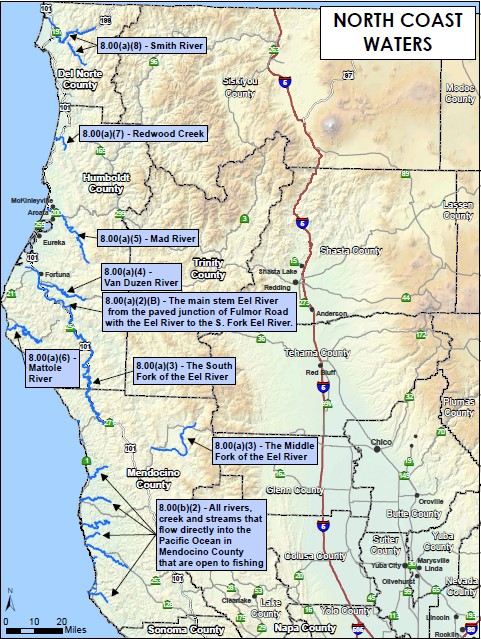
- Smith River: The main stem Smith River from the mouth of Rowdy Creek to the mouth of Patrick Creek (tributary of the Middle Fork Smith River); the South Fork Smith River from the mouth upstream approximately 1000 feet to the County Road (George Tyron) bridge and Craigs Creek to its confluence with Jones Creek; and the North Fork Smith River from the mouth to its confluence with Stony Creek.
- Redwood Creek: The main stem of Redwood Creek from the mouth to its confluence with Bond Creek.
- Mad River: The main stem Mad River from the Hammond Trail Railroad Trestle to Cowan Creek.
- Eel River: Split into two sections: 1) From the river's mouth to Fulmor Road, at its paved junction with the south bank of the Eel River. 2) From Fulmor Road, at its paved junction with the south bank of the Eel River, to South Fork Eel River.
- Van Duzen River: The main stem Van Duzen River from its junction with the Eel River to the end of Golden Gate Drive near Bridgeville (approximately 4,000 feet upstream from the Little Golden Gate Bridge).
- South Fork Eel River: The South Fork of the Eel River downstream from Rattlesnake Creek to its junction with the Eel River.
- Mendocino Coast Streams: All rivers, creeks, and streams that flow directly into the Pacific Ocean in Mendocino County, except for the Russian and Gualala Rivers.
Low-Flow Restrictions effective January 1 through April 30 for the following waters:
- Middle Fork Eel: From the mouth to Bar Creek.
- Mattole River: From 200 yards upstream of the mouth to the confluence with Honeydew Creek.
Decisions to open or close waters are made on Monday for fishing Tuesday/Wednesday, Wednesday for fishing Thursday/Friday, and Friday for fishing Saturday/Sunday/Monday. The Department may also open waters at any time if minimum flows are exceeded and expected to remain above the threshold until the next decision day. Since decisions are made 1-3 days before the status is effective, forecasts are used rather than real-time flows. Like any weather forecast, these predictions have a margin of error, so the status of waters may not always align with current flows.