Morro Bay State Marine Reserve/State Marine Recreational Management Area

a rounded rock, several stories tall, lies off a seaside town

Overview

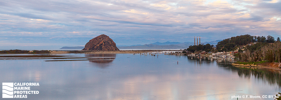
Morro Bay Estuary is a semi-enclosed body of water protected from full exposure to the Pacific Ocean by a lengthy sandspit running south from Morro Rock. Located in San Luis Obispo County, this estuary is one of the largest wetland ecosystems on California’s central coast. Fresh water flowing from Chorro and Los Osos creeks mixes with salt water from the ocean, creating a range of diverse ecosystems in the estuary that support many sensitive species.

Morro Bay State Marine Reserve (SMR) and Morro Bay State Marine Recreational Management Area (SMRMA) are neighboring marine managed areas that encompass nearly four square miles of this estuary. Morro Bay SMR protects less than one square mile of a very shallow, inland portion of the estuary including mostly tidal flats and coastal marsh habitats. Morro Bay SMRMA protects more than three square miles of sandy beach, tidal flat, coastal marsh, and eelgrass bed habitats. The estuary provides critical bird habitat, and is recognized as a National Estuary; the bay is also home to a small commercial fishing fleet, and partially borders the charming fishing and tourist town of Morro Bay.

Regulations

Morro Bay SMR

It is unlawful to injure, damage, take, or possess any living, geological, or cultural marine resource.

California Code of Regulations Title 14, Section 632(b)(92)(opens in new tab)

Morro Bay SMRMA

It is unlawful to injure, damage, take, or possess any living, geological, or cultural marine resource, EXCEPT:
Take of waterfowl in accordance with general waterfowl regulations is allowed. North of latitude 35° 19.700’ N only: Recreational take of finfish, commercial oyster aquaculture, and storing finfish taken outside of the SMRMA for bait purposes is allowed.

California Code of Regulations Title 14, Section 632(b)(91)(opens in new tab)

Quick Facts

Morro Bay SMR

MPA size: 0.88 square miles

Shoreline span: 0.8 miles

Depth range: 0 to 10 feet

Habitat composition*:

  • Estuary: 0.83 square miles
  • Coastal marsh: 1.64 square miles

Morro Bay SMRMA

SMRMA size: 3.07 square miles

Depth range: 0 to 18 feet

Shoreline span: 5.7 miles

Habitat composition*:

  • Estuary: 3.02 square miles
  • Eelgrass: 0.99 square miles
  • Coastal marsh: 2.41 square miles

*Habitat calculations are based on 3-dimensional area and may exceed the total MPA area listed above.

Photo Gallery

13 SEP
2022

Round stingray at Morro Bay SMRMA

0

photo © wssailor, CC BY-NC 2.0

Showing 0 Comment

Video Gallery

California's MPA Network

About Morro Bay State Marine Reserve/State Marine Recreational Management Area

Natural History

Morro Rock, sailboats
Sailboats and Morro Rock, Morro Bay SMRMA. photo © C. Day, CC BY-NC 2.0

Approaching from a distance, the first indication a visitor is near Morro Bay is the appearance of Morro Rock on the horizon. Formed approximately 23 million years ago, Morro Rock stands more than 575 feet tall and is the most visible in a chain of volcanic plugs in the area, remnants of extinct volcanoes.

Situated about 600 feet south of Morro Rock is the beginning of an approximately four-mile-long sandspit that protects Morro Bay from direct exposure to ocean waves. This protection helped to create Morro Bay Estuary, a semi-enclosed body of water that covers 2,300 acres. Cold seawater enters the estuary through a small inlet near Morro Rock and mixes with fresh water from Chorro and Los Osos creeks. The mix of fresh and salt water creates unique habitats including beaches, tidal flats, marshes and eelgrass beds. Morro Bay's eelgrass beds moderate currents and wave action, and filter and decontaminate the bay’s water.

While Morro Bay serves as an important resting and foraging ground for migratory birds, it is also a year-round home for many animals that rely on the sheltered waters for food and breeding grounds. California brown pelicans search for fish, rafts of southern sea otters float on their backs with pups on their bellies, and bat rays glide over the shallow mudflats at high tide. Invertebrates such as Pacific oysters, Washington and gaper clams, ghost shrimp, and shore crabs inhabit the mudflats. Fishes including topsmelt, shiner perch, bay pipefish, and Pacific staghorn sculpin also make their homes here. The dense meadows of eelgrass found within the SMR and the SMRMA are nursery grounds for rockfish, flatfish, and a variety of invertebrates, and serve as an important resting and foraging area for the black brant, a small goose that feeds on eelgrass. Morro Bay Estuary is also home to more than a dozen threatened or endangered species such as the Morro shoulderband snail, California red-legged frog, and California black rail.

Cultural History

boats, sandspit, Morro Rock
Morro Rock and the long sandspit that shelters recreational boats in Morro Bay SMRMA. photo © M. Trimble, CC BY-NC-ND 2.0

For centuries, Native American Tribes in California have relied on marine and coastal resources. Many continue to regularly harvest marine resources within their ancestral territories and maintain relationships with the coast for ongoing customary uses.

The Chumash have occupied Morro Bay for thousands of years, and once had a large, long-term settlement above the mouth of Morro Creek. Archeological records of Chumash inhabitants reveal evidence of a complex society spanning the coast from Malibu in the south to Morro Bay in the north, including the Channel Islands. The estuary provided the Chumash with abundant food and other natural resources. In coastal areas, natural resources were so plentiful that many villages existed continuously on their original sites for as long as 9,000 years. The tomol, a traditional Chumash redwood plank canoe, provided essential transportation for trading and fishing.

The first recorded European exploration of the area occurred in 1542, when Portuguese explorer Juan Rodriguez Cabrillo arrived in the area and named Morro Rock “El Morro”, meaning crown-shaped hill. Settlement began in the late 1700s with the Spanish Portola expedition, which traveled down the Los Osos Valley from modern day San Luis Obispo bringing agriculture, ranching, and missions to the area.

The town of Morro Bay was founded in 1870 to support the export of dairy and ranch products. Today, the commercial fishing fleet lands fresh catches of halibut, sole, rockfish, and albacore at the docks in Morro Bay, while commercial aquaculture operations grow oysters in the shallow back bay. Charter boats take recreational anglers out on the ocean to catch many of the same species sought by the commercial fleet. The town has also become a tourist destination for those seeking a beach holiday.

Recreation

kayakers and a paddleboarder paddling near shore
Kayakers on Morro Bay, Morro Rock in the background. photo © M. Baird, CC BY 2.0

The Morro Bay SMR and SMRMA offer many recreational opportunities such as kayaking, paddle boarding, birdwatching, snorkeling, and swimming. On land, the miles of trails in the area make Morro Bay a great place for hiking and observing wildlife; be sure to bring binoculars for observation. Visitors often catch glimpses of dolphins, seals, sea lions, and southern sea otters, and birdwatchers can rejoice with more than 200 species visiting the area, and up to 20,000 shorebirds stopping to feed on the mudflats throughout winter. Whale watching is one of the most popular attractions outside the bay, with humpback, gray, minke, and blue whales frequently observed from charter boats.

No take of any kind is permitted within Morro Bay SMR, while recreational hunting of waterfowl is allowed in the SMRMA, along with recreational fishing for finfish in the northern portion of the SMRMA. The southern portion of Morro Bay SMRMA is off limits to take of any marine resources.

Coordinates

Morro Bay SMR

This area includes the area below mean high tide line within Morro Bay east of longitude 120° 50.340′ W.

California Code of Regulations Title 14, Section 632(b)(92)

Morro Bay SMRMA

This area includes the area below mean high tide within Morro Bay east of the Morro Bay entrance breakwater and west of longitude 120° 50.340′ W.

Take of all living, geological, or cultural marine resources is prohibited except certain specified activities are allowed north of latitude 35° 19.700′ N. (See link below or "Regulations" section above for a list of allowed activities).

California Code of Regulations Title 14, Section 632(b)(91)

Downloads for Morro Bay State Marine Reserve

Map

Map of Morro Bay State Marine Reserve - click to enlarge in new tab

Facts, Map & Regulations

MPA fact sheet - click to enlarge in new tab

Downloads for Morro Bay State Marine Recreational Management Area

Map

Map of Morro Bay State Marine Recreational Management Area - click to enlarge in new tab

Facts, Map & Regulations

MPA fact sheet - click to enlarge in new tab