Montara State Marine Reserve, and Pillar Point State Marine Conservation Area

beach and black reef line a grassy promontory

Overview

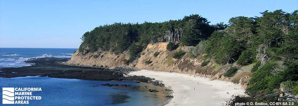
Montara State Marine Reserve (SMR) and Pillar Point State Marine Conservation Area (SMCA) are two neighboring marine protected areas (MPAs) located along the scenic coastline of San Mateo County, just south of San Francisco. Almost 12 square miles of marine habitat is protected within Montara SMR, to depths greater than 160 feet. And in Pillar Point SMCA, more than 6½ square miles of marine habitat are protected, to depths greater than 170 feet. These two MPAs feature sandy beaches, rocky shores, surfgrass beds, expansive sandy seafloor, and an immense rocky reef with kelp forests. The popularity of this coastal area is primarily due to the accessible and expansive rocky shoreline habitat. Spanning more than three miles, Montara SMR's rocky coast includes beautiful tidepools full of chitons, anemones, urchins, limpets, barnacles, crabs, and vibrantly colored nudibranchs (sea slugs).

The SMCA protects fish and invertebrates such as rockfish, lingcod, greenlings, surfperches, halibut, rays, and crabs. Offshore of Pillar Point, the reef structure is responsible for the exceptional surf break known as Mavericks, which is located near the southern boundary of Pillar Point SMCA.

With more than 300 species of invertebrates, fish, seabirds, and marine mammals, Montara SMR and Pillar Point SMCA offer visitors ample opportunity to appreciate California’s marine life both from shore and on the water.

Regulations

Montara SMR

It is unlawful to injure, damage, take, or possess any living, geological, or cultural marine resource.

California Code of Regulations Title 14, Section 632(b)(65)(opens in new tab)

Pillar Point SMCA

It is unlawful to injure, damage, take, or possess any living, geological, or cultural marine resource, EXCEPT:

Recreational take of Dungeness crab by trap, market squid by hand-held dip net, and pelagic finfish (northern anchovy, barracudas, billfishes, dorado (dolphinfish), Pacific herring, jack mackerel, Pacific mackerel, salmon, Pacific sardine, blue shark, salmon shark, shortfin mako shark, thresher shark, swordfish, tunas, Pacific bonito, and yellowtail) by trolling is allowed. Commercial take of Dungeness crab by trap, market squid by round-haul net, and pelagic finfish (no commercial take of marlin is allowed) by trolling or round-haul net is allowed. Not more than five percent by weight of any commercial pelagic finfish or market squid catch landed or possessed shall be other incidentally taken species.

California Code of Regulations Title 14, Section 632(b)(66)(opens in new tab)

Quick Facts

Montara SMR

MPA size: 11.81 square miles

Shoreline span: 3.2 miles

Depth range: 0 to 168 feet

Habitat composition*:

  • Sand/mud: 8.26 square miles
  • Rock: 8.65 square miles

Pillar Point SMCA

MPA size: 6.70 square miles

Shoreline span: 0.3 miles

Depth range: 0 to 174 feet

Habitat composition*:

  • Sand/mud: 5.73 square miles
  • Rock: 2.07 square miles

*Habitat calculations are based on 3-dimensional area and may exceed the total MPA area listed above.

Photo Gallery

Video Gallery

California's MPA Network

About Montara State Marine Reserve, and Pillar Point State Marine Conservation Area

Natural History

fish, sea star and anemone on the sea florr
Gopher rockfish, bat star, and fish-eating anemone in Pillar Point SMCA. CDFW/MARE photo

Powerful coastal upwelling brings nutrient-rich water from the depths to the surface and fuels a thriving marine ecosystem in these MPAs. This upwelling, combined with an immense rocky reef structure that extends more than a mile out to sea, creates the backdrop for one of the most biodiverse locations in the state.

On the shore, tidepools filled with mussels, barnacles, algae, urchins, anemones, and other creatures provide a glimpse of what can be found in the waters offshore. The caves, walls, boulders, and canyons in offshore waters are prime habitat for a suite of rocky reef species. Large numbers of reef fishes, including gopher rockfish, blue rockfish, canary rockfish, black rockfish, lingcod, cabezon, and monkeyface prickleback, roam the protective cover of the rocks, while abalone, urchins, and octopus hide in crevices. Sharks, rays, harbor seals and sea lions patrol the waters for food, and migrating whales including gray whales, blue whales, and humpback whales often stop in the area to feast on krill and plankton.

Beyond the outer edge of the reef in the deeper, sandy seafloor habitat, halibut, Dungeness crab, and rays are found in large numbers. This rich environment also supports seabirds like the sooty shearwater, western gull, common murre, Cassin’s auklet, and many other species.

Cultural History

water flows across algae covered tidepool rocks
Tidepools at Montara SMR. photo © R. Gourley, CC BY-NC 2.0

For centuries, Native American Tribes in California have relied on marine and coastal resources. Many Native American Tribes in California continue to regularly harvest marine resources within their ancestral territories and maintain relationships with the coast for ongoing customary uses. In pre-European times, the Ohlone were a semi-nomadic people who lived in small villages between San Francisco Bay in the north, to the Salinas River Valley and what is now southern Monterey County in the south. The Ohlone traditionally subsisted off abalone, urchins, limpets, fish, and other marine life that abounded in the intertidal zone. The area around Montara remained free from European influence until the Portola Expedition of 1769.

The area near Montara and Pillar Point, as well as Half Moon Bay which is southeast of the MPAs, were used by the Spanish as cattle, horse, and sheep grazing areas for the San Francisco Mission, established in 1776. Following two disastrous shipwrecks in 1868 and 1872, a fog signal was erected in 1875, and in 1928 Point Montara acquired a lighthouse to mark the dangerous reef. Following a series of building additions around the lighthouse between 1900 and 1960, a hostel was opened on the property in 1980, and remains in operation today.

In the Montara SMR, one of California’s first instances of marine protection can be found. The Fitzgerald Marine Reserve, established in 1969 to protect the tidepool area from habitat degradation, is now encompassed by Montara SMR, and continues to boast one of the most highly visited tidepool areas in the state.

Recreation

a narrow, grassy plateau lined with sandy beach extending into the ocean
Southern edge of Pillar Point SMCA. photo © W. Hsieh, CC BY-NC 2.0

Montara SMR and Pillar Point SMCA allow for many different types of ocean recreation. Easy to access and filled with marine life, tidepools can be explored along the coastline at low tide. Many bird and whale watchers frequent the bluffs, and a network of hiking trails affords views of the coastline and ocean.

No take is allowed within Montara SMR, but Pillar Point SMCA offers anglers and crabbers opportunities including trolling for pelagic finfish, trapping Dungeness crab, and more. Please make sure to check all regulations before heading into Pillar Point SMCA to fish. Visitors are welcome to stay at the Point Montara Lighthouse Hostel for easy access to the coastline.

A visitor center, coastal access, restrooms, and parking are also available at the Fitzgerald Marine Reserve in Moss Beach, within the boundary of Montara SMR. For those with bravery to spare and years of experience, Mavericks is a world-famous surf spot just off Pillar Point. Massive waves break there in winter, bringing many of the world's best surfers to challenge the ocean’s fury. This is an expert-only spot, but simply watching from the bluffs or a boat can be thrilling. East of Pillar Point SMCA, Pillar Point Harbor has a public boat launch, parking, and restrooms.

Coordinates

Montara SMR

This area is bounded by the mean high tide line and straight lines connecting the following points in the order listed except where noted:

37° 32.700' N. lat. 122° 31.000' W. long.;
37° 32.700' N. lat. 122° 34.908' W. long.; thence southward along the three nautical mile offshore boundary to
37° 30.000' N. lat. 122° 34.608' W. long.; and
37° 30.000' N. lat. 122° 29.920' W. long.

California Code of Regulations Title 14, Section 632(b)(65)

Pillar Point SMCA

This area is bounded by the mean high tide line and straight lines connecting the following points in the order listed except where noted:

37° 30.000′ N. lat. 122° 29.920′ W. long.;
37° 30.000′ N. lat. 122° 34.608′ W. long.; thence southward along the three nautical mile offshore boundary to
37° 28.330′ N. lat. 122° 33.489′ W. long.;
37° 28.330′ N. lat. 122° 30.830′ W. long.;
37° 29.180′ N. lat. 122° 30.360′ W. long.;
37° 29.740′ N. lat. 122° 29.970′ W. long.; and
37° 29.733′ N. lat. 122° 29.950′ W. long.

California Code of Regulations Title 14, Section 632(b)(66)

Downloads for Montara State Marine Reserve

Map

Map of Montara State Marine Reserve - click to enlarge in new tab

Facts, Map & Regulations

 - click to enlarge in new tab

Downloads for Pillar Point State Marine Conservation Area


Map

Map of Pillar Point State Marine Conservation Area - click to enlarge in new tab

Facts, Map & Regulations

MPA fact sheet - click to enlarge in new tab