Upper Newport Bay State Marine Conservation Area

marsh next to bay and city in the distance

Overview

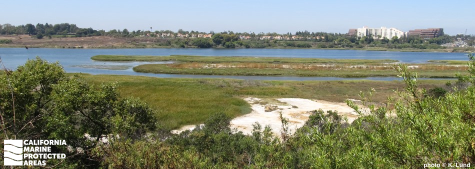
Upper Newport Bay State Marine Conservation Area (SMCA) protects a little more than one square mile of upland lagoon habitat including tidal flats and coastal marsh. A plethora of small mammals, fish, crustaceans, worms, clams, and birds, including the endangered Ridgway's rail and the California least tern, can be found within the marine protected area's (MPA's) wetlands.

Since 1975, Upper Newport Bay has been designated as a nature preserve. It is one of the largest of only a few remaining natural estuarine ecosystems in Southern California. The wetlands offer a popular recreation area for riding bikes and horses, hiking, kayaking, birdwatching, and simply enjoying the tranquil waters hidden within a bustling city.

Regulations

It is unlawful to injure, damage, take, or possess any living, geological, or cultural marine resource, EXCEPT:
Recreational take of finfish by hook-and-line from shore only is allowed. Shoreline access limited to established trails, paths, or other designated areas. Restrictions exist for boating and swimming. See CCR T14 §632(b) for details.

California Code of Regulations Title 14, Section 632(b)(132)(opens in new tab)

Quick Facts

MPA size: 1.24 square miles

Habitat composition*:

  • Estuary: 1.20 square miles
  • Coastal marsh: 3.71 square miles

*Habitat calculations are based on 3-dimensional area and may exceed the total MPA area listed above.

Photo Gallery

1 JUL
2022

Tricolored heron in Upper Newport Bay SMCA

0

photo © R. Woodruff, CC BY-NC 2.0

Showing 0 Comment

Video Gallery

Southern California Marine Protected Area Highlights
California's MPA Network

About Upper Newport Bay State Marine Conservation Area

Natural History

pelican flying low over water
Many species of birds, like the brown pelican, take refuge in Upper Newport Bay SMCA. photo © S. O'Donnell, CC BY-NC 2.0

The upper portion of Newport Bay was formed nearly 15 million years ago by geologic uplifting events, and over time the Santa Ana River sculpted the bay itself into the immense low-lying wetland it is today. Upper Newport Bay SMCA protects the inland delta often referred to as the Newport Back Bay. As the largest remaining estuary in Southern California, a mix of marshland, tidal flats, sand bars, and striking bluffs serve as habitat to many unique plants and animals.

Because of its large size and location, Upper Newport Bay is considered one of the premier birdwatching sites in the state. During winter migration, around 30,000 birds may be using Upper Newport Bay at any given point in time. It provides critical habitat and refuge to rare or endangered species, including the light-footed clapper rail, Belding's savannah sparrow, black rail, and California least tern.

Beneath the surface of the brackish inland water, tidal flats and eelgrass beds provide essential nursery habitat for California halibut, barred sand bass, and croaker. Striped mullet are frequently spotted leaping from the water and, along with other bait fish like anchovy and topsmelt, provide food for birds and smoothhound sharks, among many other predators. Medusa worms, jackknife clams, and bent nose clams bury themselves beneath the mud, where they filter nutrients and plankton from the silty water, and hope to avoid stingrays looking for a meal along the shallow bottom. At lower tides, striped shore crabs and California horn snails become exposed along the shorelines.

Cultural History

marsh and grassland adjacent to waterway
The Acjachemen used marsh plants to make a variety of items, including baskets and boats. Photo © cyclotourist, CC BY-NC 2.0

For centuries, Native American Tribes in California have relied on marine and coastal resources. Many Native American Tribes in California continue to regularly harvest marine resources within their ancestral territories and maintain relationships with the coast for ongoing customary uses. Upper Newport Bay is within the traditional territory of the Tongva and Acjachemen peoples. These Tribes developed several specialized crafts and tools, including nets, fishhooks, and tule canoes. The canoes enabled travel offshore and access to deeper water marine resources such as fish from the kelp beds.

Arriving in the 18th century, Spanish missionaries likely encountered vast systems of estuaries and wetlands. Until 1862, Upper Newport Bay waters flowed unrestricted to the Pacific Ocean. Today, the bay is divided by Highway 1, forming Lower Newport Bay and Upper Newport Bay. When the Highway 1 Bridge was originally constructed in 1921, the channel between the upper and lower bay was reduced, changing the configuration of the Newport Back Bay. Between 1950 and 1970, development boomed in the area, leaving the Upper Bay as the only remaining unaltered wetland area in the bay. Many recognized its local importance and attempted to protect the upper bay from plans for development into a waterskiing area.

After a decade of lawsuits, the undeveloped portions of Upper Newport Bay became an ecological reserve in 1975 and the California Department of Fish and Wildlife assumed management of the area. By 1989, Orange County established the Upper Newport Bay Nature Preserve in the same location. In the early 2000s, a massive restoration and dredging project began, which continues today in the hopes of restoring this critical wetland habitat.

Recreation

shop at boat launch
Upper Newport Bay SMCA can be enjoyed in a number of ways, including by boat, by bicycle, or on foot. CDFW photo by P. Serpa

This easily accessible estuary provides many opportunities for recreation. Visit the Upper Newport Bay Nature Preserve, and the Peter and Mary Muth Interpretive Center to delve deeper into the area’s natural and cultural history. You can also visit the California Department of Fish and Wildlife’s Back Bay Science Center, an educational and research facility, during their “community days” to learn about the science and history of the bay.

Back Bay Drive, a multi-use road shared with bikers, hikers, and cars, provides incredible opportunities for being close to the water and viewing shorebirds and waterfowl. A 10.5-mile bike loop around Newport Back Bay and designated trails for horseback riding provide unique recreational opportunities amid a lively city. Consider taking a guided kayak tour or, to launch your own kayak or canoe, visit Castaways Park or Northstar Beach, which have no parking or launch fees. The recreational take of finfish by hook-and-line from shore is permitted in the SMCA.

Coordinates

This area includes the waters below the mean high tide line within Upper Newport Bay northeastward of Pacific Coast Highway approximated by a line between the following two points:

33° 37.014' N. lat. 117° 54.237' W. long.;
33° 37.014' N. lat. 117° 54.336' W. long.; and southwestward of Jamboree Road approximated by a line between the following two points:
33° 39.071' N. lat. 117° 52.021' W. long.; and
33° 39.027' N. lat. 117° 52.014' W. long.

California Code of Regulations Title 14, Section 632(b)(132)

Downloads for Upper Newport Bay State Marine Conservation Area

Map

Map of Upper Newport Bay State Marine Conservation Area - click to enlarge in new tab

Facts, Map & Regulations

MPA fact sheet - click to enlarge in new tab