Swami's State Marine Conservation Area, and San Elijo Lagoon State Marine Conservation Area (No-Take)

people using a small beach

Overview

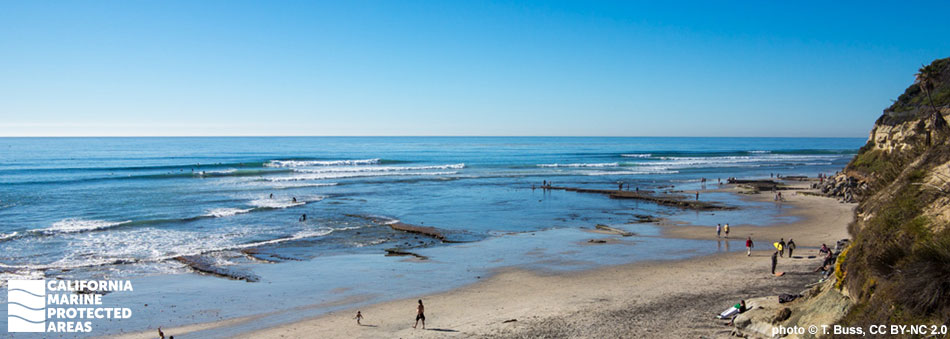
Swami’s State Marine Conservation Area (SMCA) is San Diego County’s largest marine protected area (MPA). Located 75 miles south of Los Angeles and offshore of Encinitas, California, the MPA is named after the world-famous surf spot, Swami’s. Swami’s SMCA covers almost 13 square miles of marine habitat, including miles of sandy beach, rocky intertidal areas, deepwater canyon habitat, coastal marshes, surfgrass beds, rocky reefs, and kelp forests. Swami’s SMCA protects large areas of surfgrass and kelp forest ecosystems that are ecologically unique to the region south of Palos Verdes.

Swami’s SMCA is adjacent to the San Elijo Lagoon SMCA (No-Take), which covers roughly one-half square mile of coastal wetland habitat. In addition to being a no-take area, boating, swimming and wading are also prohibited in San Elijo Lagoon SMCA (No-Take). The estuary is connected to the Pacific Ocean under Highway 101, and is subject to substantial tidal influence, which brings saltwater and nutrients from the ocean to enrich the lagoon. Coupled with consistently temperate weather, the expanses of sandy beach and tidepools attract beachgoers, swimmers, nature lovers, surfers, and fishermen year-round.

Regulations

Swami's SMCA

It is unlawful to injure, damage, take, or possess any living, geological, or cultural marine resource, EXCEPT:
Recreational take by hook-and-line from shore, and white seabass and pelagic finfish (northern anchovy, barracudas, billfishes, dorado (dolphinfish), Pacific herring, jack mackerel, Pacific mackerel, salmon, Pacific sardine, blue shark, salmon shark, shortfin mako shark, thresher shark, swordfish, tunas, Pacific bonito, and yellowtail) by spearfishing is allowed.

California Code of Regulations Title 14, Section 632(b)(138)(opens in new tab)

San Elijo Lagoon SMCA (No-Take)

It is unlawful to injure, damage, take, or possess any living, geological, or cultural marine resource. Take incidental to certain permitted activities may be allowed. Other restrictions may apply. See CCR T14 §632(b) (link below) for details.

California Code of Regulations Title 14, Section 632(b)(139)(opens in new tab)

Quick Facts

Swami's SMCA

MPA size: 12.71 square miles

Shoreline span: 3.5 miles

Depth range: 0 to 982 feet

Habitat composition*:

  • Rock: 0.90 square miles
  • Sand/mud: 12.26 square miles

San Elijo Lagoon SMCA (No-Take)

MPA size: 0.5 square miles

Habitat composition*:

  • Estuary: 0.42 square miles
  • Coastal marsh: 1.59 square miles

*Habitat calculations are based on 3-dimensional area and may exceed the total MPA area listed above.

Photo Gallery

30 JUN
2022

A brittle star in Swami's SMCA

0

Photo © kcinciarelli, CC BY-NC 2.0

Showing 0 Comment

Video Gallery

Swami’s State Marine Conservation Area

Southern California Marine Protected Area Highlights

California's MPA Network

About Swami's State Marine Conservation Area, and San Elijo Lagoon State Marine Conservation Area (No-Take)

Natural History

a sandy beach below a yellow cliff
Looking north from shore at Swami's SMCA. Photo © T. Buss, CC BY 2.0

Like much of coastal Southern California, the geological history of Swami’s SMCA is a tale of tectonic activity. Swami’s Reef and Cardiff Reef contain evidence of ancient lagoons in the form of fossils that are littered throughout the rocks. The large sandy portions of the onshore beaches and submerged underwater areas are fed by sea cliff erosion of sandy bluffs. The majority of Swami’s SMCA is made up of sandy seafloor, with rocky reef, surfgrass beds, and kelp forest patches scattered throughout. Coastal marshland can also be found where some creeks and lagoons meet the ocean, most notably at the mouth of the San Elijo Lagoon. 

The surfgrass, sandy seafloor, rocky reef, kelp forest, and tidepool habitats of Swami’s SMCA support nearshore and intertidal marine life. At low tide, sea stars, urchins, anemones, and octopus may be found lurking in rocky tidepools, while seabirds catch tidewater gobies and crabs from shallow pools. Offshore, California halibut, bat rays, and the occasional white seabass patrol the surfgrass beds, while invertebrates and juvenile rockfish find refuge in the large clumps of kelp, rock, and grasses. In the kelp forests and rocky reefs, kelp bass, señorita, California sheephead, a variety of surfperch, leopard sharks, and invertebrates like California spiny lobsters, crabs, and octopus navigate through the rocks and tall strands of kelp.

San Elijo Lagoon consists of coastal marsh habitat and shallow estuary waters that provide important nursery and feeding areas for fish like topsmelt, killifish, and arrow goby, and invertebrates such as fiddler crab, mantis shrimp, and California horn snail. This lagoon is also recognized as a prominent area for waterfowl and migratory birds that stop here during their long migrations, with species like American avocet, California least tern, bufflehead, brown pelicans, least terns, and great blue herons as common visitors.


Cultural History

exposed reef and ocean surf beyond
Exposed reef at Swami's SMCA. Photo © T. Buss, CC BY 2.0

For centuries, Native American Tribes in California have relied on marine and coastal resources. Many Native American Tribes in California continue to regularly harvest marine resources within their ancestral territories and maintain relationships with the coast for ongoing customary uses. The Kumeyaay and Luiseño peoples lived in this area for thousands of years before Europeans arrived. As coastal natives, they had access to many marine resources that were fundamental to their survival. Remnants of shell middens (piles of disposed shells) indicate that these hunter-gatherers were dependent on retrieving food from the sea. Tidepools offered abalone, urchins, and seaweeds, and the Kumeyaay harvested these resources for food and jewelry.

European exploration near Swami’s SMCA began in 1602 when Sebastian Vizcaino and his exploration party were sent by Spain to map the California coast. Settlement did not begin until 1769 with the Portola Expedition and the beginning of the Mission Era. After the United States acquired California in 1848, the area around Encinitas was opened to homesteading and a small community began to form. By the turn of the century the small homesteads had grown in number and a town developed in what is now Cardiff-by-the-Sea. Frank Cullen bought much of the land in 1911, subdividing and building homes and roads, and marketing the area as a seaside getaway from the bustle of San Diego. One of the major developments was the Paramahansa Yogananda Self-Realization Fellowship, which was founded in 1920 and remains one of the big draws to the area today. The town grew steadily as a residential and vacation area for neighboring San Diego and in 1986 was incorporated into the city of Encinitas.

Recreation

surfer riding a wave
A surfer riding a wave at Swami's SMCA. Photo © B. Baldwin, CC BY-NC 2.0

Located along the heart of the Encinitas coastline, lodging, restaurants, markets, and shopping are plentiful near these MPAs. Sandy beaches stretch for miles along the coast, and public parking, bathrooms, and beach access can be easily found along Highway 1. In places like Swami’s Reef and Cardiff Reef, sandy beach is interspersed with rocky intertidal areas that provide opportunities for tidepooling during low tides. As the tide goes out, shallow pools form in the rocky shores. The tidepools are full of hermit crabs, limpets, chitons, urchins, and small fish like sculpin, providing an opportunity to explore the marine world without diving in the ocean.

Several breaks, most notably Swami’s Reef, are popular for surfing. The coastline includes spots suitable for surfers of all skill levels, and while it can get crowded at the better-known breaks, a quick walk down the beach will often be rewarded with uncrowded waves. In Swami’s SMCA, recreational fishermen are permitted to catch fish by hook-and-line from shore, as well as spearfish for fish like white seabass and yellowtail.

Coordinates

Swami's SMCA

This area is bounded by the mean high tide line and straight lines connecting the following points in the order listed except where noted:

33° 02.900′ N. lat. 117° 17.927′ W. long.;
33° 02.900  N. lat. 117° 21.743′ W. long.; thence southward along the three nautical mile offshore boundary to
33° 00.000' N. lat. 117° 20.398′ W. long.; and
33° 00.000′ N. lat. 117° 16.698′ W. long.; thence northward along the mean high tide line onshore boundary to
33° 00.962′ N. lat. 117° 16.850′ W. long.; and
33° 00.980′ N. lat. 117° 16.857′ W. long.

California Code of Regulations Title 14, Section 632(b)(138)

San Elijo Lagoon SMCA (No-Take)

This area includes the waters below the mean high tide line within San Elijo Lagoon southeastward of a straight line between the following two points:

33° 00.980′ N. lat. 117° 16.857′ W. long.; and
33° 00.962′ N. lat. 117° 16.850′ W. long.

California Code of Regulations Title 14, Section 632(b)(139)

Downloads for Swami's State Marine Conservation Area

Map

Map of Swami's State Marine Conservation Area - click to enlarge in new tab

Facts, Map & Regulations

MPA fact sheet - click to enlarge in new tab

Downloads for San Elijo Lagoon State Marine Conservation Area (No-Take)

Map

Map of San Elijo Lagoon State Marine Conservation Area - click to enlarge in new tab

Facts, Map & Regulations

MPA fact sheet - click to enlarge in new tab