Stewarts Point State Marine Reserve/State Marine Conservation Area

rugged coastline

Overview

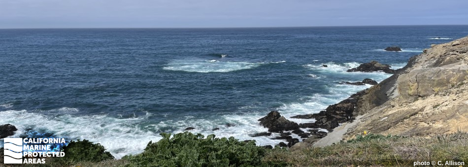
Stewarts Point State Marine Reserve (SMR) and Stewarts Point State Marine Conservation Area (SMCA) are located along the rugged Sonoma coast, six miles south of Gualala and 80 miles northwest of San Francisco. 

The SMR covers a little more than 24 square miles, spanning from the shore out to the three-nautical-mile state water boundary, and reaching depths of nearly 300 feet. With over seven miles of shoreline, this marine protected area (MPA) contains complex rocky and nearshore habitats including coves, shelves, cobbled reefs, kelp forests, tidepools, beaches, and deep sandy seafloor.

The SMCA covers approximately one square mile of predominately nearshore habitats ranging from shore to depths of around 130 feet. With over four miles of shoreline, the SMCA contains complex rocky and sandy beach habitats including coves, shelves, cobbled reefs, kelp forests, and tidepools. 

With abundant marine life including a variety of plants, marine mammals, fish, and invertebrates, these MPAs are popular destinations for scuba and free divers, tidepoolers, hikers, beachgoers, and whale watchers. The SMCA is a popular destination for fishermen, as well.

Regulations

Stewarts Point SMR

It is unlawful to injure, damage, take, or possess any living, geological, or cultural marine resource.

California Code of Regulations Title 14, Section 632(b)(34)(opens in new tab)

Stewarts Point SMCA

It is unlawful to injure, damage, take, or possess any living, geological, or cultural marine resource, EXCEPT:
Recreational take of plants (no sea palm), invertebrates, finfish by hook-and-line, surf smelt by beach net, and species listed in CCR T14 §28.80 by hand-held dip net is allowed.

California Code of Regulations Title 14, Section 632(b)(33)(opens in new tab)

Quick Facts

Stewarts Point SMR

MPA size: 24.06 square miles

Shoreline span: 7.3 miles

Depth range: 0 to 294 feet

Habitat composition*:

  • Rock: 3.62 square miles
  • Sand/mud: 22.38 square miles

Stewarts Point SMCA

MPA size: 1.19 square miles

Shoreline span: 3.9 miles

Depth range: 0 to 134 feet

Habitat composition*:

  • Rock: 2.31 square miles
  • Sand/mud: 0.21 square miles

*Habitat calculations are based on 3-dimensional area and may exceed the total MPA area listed above.

Photo Gallery

30 JUN
2022

Sunset just south of Stewarts Point in Stewarts Point SMCA

0

Photo © P. Dirden, CC BY-NC-ND 2.0

Showing 0 Comment

Video Gallery

California's MPA Network

About Stewarts Point State Marine Reserve/State Marine Conservation Area

Natural History

purple sea urchins, a limpet, algae covered in pink coral
Numerous species like purple urchins, whitecap limpets, and coralline encrusting algae make their homes in the rocky intertidal zone at Stewarts Point SMR and SMCA. Photo © D. Osborne, CC BY-NC 2.0

The two MPAs at Stewarts Point protect a complex mix of rocky intertidal areas and reefs, kelp forests, and sandy seafloor. Coves, wash rocks, cobble and boulder beaches, and the rocky intertidal zone offer habitat for encrusting coralline algae, chitons, barnacles, limpets, and mussels, as well as mobile species like snails, gobies, and sculpins. Offshore, kelp forests are anchored to submerged rocks and reefs. Blue rockfish, black rockfish, kelp greenling, and striped perch are found throughout the MPA. On the reef, red sea urchins, purple sea urchins, crabs, gumboot chitons, and sea stars move slowly amongst sedentary anemones and sponges.

Fragments of kelp plants can wash ashore creating piles of wrack in the small, sandy beach coves. The kelp wrack provides an important source of nutrients for these isolated beaches. Clams, sand crabs, and worms buried in the sediment feed on plankton that washes over them with each incoming wave. Shorebirds probe the sand in search of a meal. Beyond the nearshore beaches and rocky reefs, both MPAs encompass extensive, deep sandy seafloors. Here, species such as sea whips, sea pens, and anemones protrude from the ever-changing sands, while flatfish, smelt, and Dungeness crab navigate amongst occasional three-dimensional rocky structures that protrude from the sand.

Cultural History

rocky coastline
Danága, or Stewarts Point, is an important cultural site for the Kashia Band of Pomo Indians of the Stewarts Point Rancheria. Photo by C. Allison

For centuries, Native American Tribes in California have relied on marine and coastal resources. Many Native American Tribes in California continue to regularly harvest marine resources within their ancestral territories and maintain relationships with the coast for ongoing customary uses. 

Today, the federally recognized Kashia Band of Pomo Indians of the Stewarts Point Rancheria continues to maintain their traditional relationship with the coast. Located within the Stewarts Point SMCA is Stewarts Point, traditionally called Danága by the Kashia. The Tribe holds ceremonies and engages in traditional cultural practices such as gathering, fishing, and prayer at Danága throughout the year. The reservation of Stewarts Point Rancheria, Su’ Nu’ Nu’ Shinal, is located near the MPAs. 

This area was frequented by Russians and native Alaskan hunters as early as 1812 and settled by Mexican landowners in the 1840s. By the 1850s, coastal towns developed as the fur trade grew and cattle ranching expanded. After the Gold Rush of 1849, many former miners established ranches in the area, and lumberjacks came from New England for the region’s abundant timber resources. Established in the mid-1800s, the town of Stewarts Point remains a small community along the Sonoma County coast, with a general store and post office. Timber and cattle ranching remain major economic drivers in the area.

Recreation

purple urchins, an ochre sea star, and mussel shells in a tidepool
Many interesting sea creatures can be found in the tidepools at Stewarts Point SMR and SMCA. Photo © washburnkristen, CC BY-NC 2.0

Visitors to Stewarts Point SMR and SMCA can expect extensive tidepools, frequent whale, seal, and sea lion sightings, and good vantage points for birdwatching. While no take is allowed in the SMR, recreational fishing activities are allowed from shore within the SMCA, and fishermen can try for rockfish and lingcod from shore using a hook-and-line .

Snorkeling, freediving, and scuba diving on the rocky reefs is also possible. Black Point has public beach access via a short trail and nearby Salt Point State Park offers easy access and a wealth of options for recreation. Fisk Mill Cove is a popular shore-based entry location for divers. It has a day use area that offers ocean views from Sentinel Rock and provides visitors with paved parking, picnic tables, barbecues, restrooms, and drinking water.


Coordinates

Stewarts Point SMR

This area is bounded by the mean high tide line and straight lines connecting the following points in the order listed except where noted:

38° 40.500' N. lat. 123° 25.345' W. long.;
38° 40.500' N. lat. 123° 30.243' W. long.; thence southward along the three nautical mile offshore boundary to
38° 35.600' N. lat. 123° 26.018' W. long.; and
38° 35.600' N. lat. 123° 20.800' W. long., except that Stewarts Point SMCA as described in subsection 632(b)(33)(A) is excluded.

California Code of Regulations Title 14, Section 632(b)(34)

Stewarts Point SMCA

This area is bounded by the mean high tide line and straight lines connecting the following points in the order listed:

38° 39.527' N. lat. 123° 24.483' W. long.;
38° 39.527' N. lat. 123° 24.851' W. long.;
38° 36.958' N. lat. 123° 23.139' W. long.;
38° 36.958' N. lat. 123° 22.468' W. long.

California Code of Regulations Title 14, Section 632(b)(33)

Downloads for Stewarts Point State Marine Reserve

Map

Map of Stewarts Point State Marine Reserve - click to enlarge in new tab

Facts, Map & Regulations

MPA fact sheet - click to enlarge in new tab

Downloads for Stewarts Point State Marine Conservation Area

Map

Map of Stewarts Point State Marine Conservation Area - click to enlarge in new tab

Facts, Map & Regulations

MPA fact sheet - click to enlarge in new tab