Southwest Seal Rock Special Closure

two seals on a rocky shore

Overview

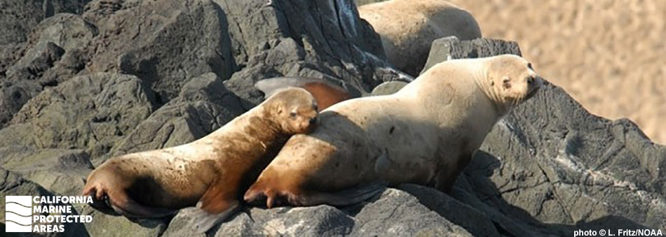
Located five miles northwest of Crescent City in Del Norte County, Southwest Seal Rock Special Closure is an offshore protected area that surrounds a small, rocky pinnacle. The special closure is especially important to Steller sea lions, who rest and give birth to pups on the remote, stony shore.

This special closure extends 300 feet seaward from any point around the entire rock, and vessels are restricted from passing through or dropping anchor. People are not allowed in the special closure, to protect the sea lions that use Southwest Seal Rock as a rookery. The nearby waters are filled with Dungeness crab, rockfish, lingcod, halibut, and salmon. Gray whales pass through the area on their 12,000-mile migration from Alaska to Baja, California. The adjacent shoreline is home to Tolowa Dunes State Park, which includes wetlands, forests, lakes, and stretches of sandy beach.

Regulations

Boating and access are restricted. Except as permitted by federal law or emergency caused by hazardous weather, no vessel shall be operated or anchored at any time from the mean high tide line to a distance of 300 ft. seaward of the mean lower low tide line of any shoreline of Southwest Seal Rock, year round.

No person except employees of the California Department of Fish and Wildlife, United States Fish and Wildlife Service, National Oceanic and Atmospheric Administration, or United States Coast Guard during performance of their official duties, or unless permission is granted by the California Department of Fish and Wildlife, shall enter the area.

California Code of Regulations Title 14, Section 632(b)(3)(opens in new tab)

Quick Facts

Special Closure size: 0.02 square miles

Depth range: 0 to 93 feet

Habitat composition*:

  • Rock: 0.04 square miles
  • Sand/mud: Less than 0.01 square miles

*Habitat calculations are based on 3-dimensional area and may exceed the total MPA area listed above.

Photo Gallery

26 SEP
2023

Shoreline near Southwest Seal Rock Special Closure

0

photo © K. Nielsen, CC BY-NC 2.0

Showing 0 Comment

Video Gallery

California's MPA Network

About Southwest Seal Rock Special Closure

Natural History

a seal swimming, head above water
California sea lion near Southwest Seal Rock Special Closure. photo © gannet55, CC BY-NC 2.0

Southwest Seal Rock juts abruptly out of the ocean off the coast of northern California, between the St. George Reef Lighthouse, which is also located offshore, and the Crescent City peninsula. Southwest Seal Rock features rocky shores that attract Steller sea lions looking for a place to haul out. Not to be confused with California sea lions, the Steller sea lions that take refuge on Southwest Seal Rock are substantially larger, with males growing up to 11 feet long and weighing nearly 2,500 pounds.

In the early summer months of May, June, and July, females give birth to 30- to 50-pound pups on Southwest Seal Rock. As a previously overhunted species, Steller sea lions have been carefully monitored and many habitats important to their success have been placed under protection.

Steller sea lions are divided into two distinct population segments, the western and the eastern. While the western population that lives in the Gulf of Alaska and the Aleutian Islands has declined and remains endangered today, the eastern population that resides in California has been rebounding steadily. The once threatened Steller sea lion population from California to Canada has recovered largely due to increased protection of important habitat and rookery sites, such as Southwest Seal Rock Special Closure.

Cultural History

a few dozen dungeness crabs crawl on a muddy seafloor
Dungeness crabs near Southwest Seal Rock Special Closure. CDFW/MARE photo

For centuries, Native American Tribes in California have relied on marine and coastal resources. Many Native American Tribes in California continue to regularly harvest marine resources within their ancestral territories and maintain relationships with the coast for ongoing customary uses. The Tolowa Dee-ni’ tribe are the indigenous peoples of the coastal region adjacent to Southwest Seal Rock. Their ancestral lands extend from just north of False Klamath Rock to the Sixes River in Oregon, and along watersheds extending inland from the sea. Living beside rich coastal waters, the Tolowa people rely on food from the sea, including salmon, smelt, and mussels.

Beginning in the 1820s, European settlers made the first outsider contact with the Tolowa Tribe. When the Gold Rush hit California in 1849, the area was further inundated with settlers who displaced the native peoples from their traditional lands. As the territories in northern California were colonized, the take of local and offshore marine resources increased and many fisheries became commercialized.

It has been widely surmised that the decline of the Steller sea lion populations throughout the 1900s was due to a combination of intense fishing that took away the sea lions’ food sources, as well as commercial sea lion hunting, which was banned in 1970. Since vessel strikes also pose a serious threat to sea lions, particularly in areas where they congregate to breed or feed, Southwest Seal Rock was added to the network of California MPAs to provide greater protection for Steller sea lions.

Recreation

seawater cuts a stream over a flat sand beach
Shoreline near Southwest Seal Rock Special Closure. photo © K. Nielsen, CC BY-NC 2.0

All boating and human activity is prohibited within the borders of Southwest Seal Rock Special Closure. The 300-foot buffer zone surrounding the rock was specifically designed to restrict all human disturbance to sea lions. However, the adjacent coastal park, Tolowa Dunes State Park, provides views of Southwest Seal Rock and is a popular place for visitors to camp and explore miles of trails that wind through dunes, ponds, and beaches. The network of trails is open to hikers, bikers, and horseback riders who can traverse through swaths of wildflowers and catch glimpses of the local wildlife, including the rare Canada Aleutian goose.

Sea lions and harbor seals often haul out on the nearby beaches that border the Pacific Ocean, where quillback rockfish, lingcod, crab, and albacore can be found flourishing in these cold waters. While the waters directly encompassing Southwest Seal Rock are off limits to people, fishing charters that launch out of Crescent City take people to the surrounding ocean, rich with fish and crab, where sportfishing is permitted.

Coordinates

A special closure is designated from the mean high tide line to a distance of 300 feet seaward of the mean lower low tide line of any shoreline of Southwest Seal Rock, located in the vicinity of 41° 48.810' N. lat. 124° 21.099' W. long.

California Code of Regulations Title 14, Section 632(b)(3)

Downloads for Southwest Seal Rock Special Closure

Map

Map of Southwest Seal Rock Special Closure - click to enlarge in new tab

Facts, Map & Regulations

MPA fact sheet - click to enlarge in new tab