Southeast Farallon Island State Marine Reserve/State Marine Conservation Area/Special Closure

aerial view of sharp rock islands

Overview

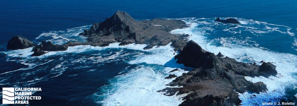
The Farallon Islands are a rugged and biologically diverse archipelago sitting 30 miles west of the Golden Gate Bridge in the Pacific Ocean. Aptly named the Farallones, the Spanish word meaning steep rocks or cliffs, the remote islands are exposed to the wind and waves of the open ocean and, aside from large numbers of seabirds and marine mammals, are quite barren on land.

There are three marine protected areas (MPAs) in the waters around Southeast Farallon Island, including Southeast Farallon Island State Marine Reserve (SMR), Southeast Farallon Island State Marine Conservation Area (SMCA), and Southeast Farallon Island Special Closure. The SMR protects more than five square miles of sandy beaches, rocky shores, surfgrass, and sandy and rocky seafloor habitat from shore to greater than 230 feet in depth. The SMCA protects nearly 13 square miles of sandy seafloor habitat from 130 to almost 400 feet in depth. The Special Closure protects a 300-foot narrow band of water surrounding the Southeast Farallon Island shoreline. Access is prohibited in most of the Special Closure to restrict boating activity in waters that surround important Steller and California sea lion, northern fur seal, and northern elephant seal haul out and rookery sites. Minimizing human activity here also helps protect the roughly 180,000 seabirds composed of 13 different species that nest on these rocky islands, including the common murre, western gull, Cassin’s auklet, and pigeon guillemot.

The marine environment surrounding the island is highly productive and supports a rich species assemblage, including rocky reef-dwelling fishes, sharks, invertebrates, and marine mammals such as seals, sea lions, and orcas, along with migrating blue whales, humpback whales, and gray whales. Visitors to the Farallon Islands can participate in whale watching and salmon trolling within the SMCA.

Regulations

Southeast Farallon Island SMR

It is unlawful to injure, damage, take, or possess any living, geological, or cultural marine resource.

California Code of Regulations Title 14, Section 632(b)(53)(opens in new tab)

Southeast Farallon Island SMCA

It is unlawful to injure, damage, take, or possess any living, geological, or cultural marine resource, EXCEPT:
Recreational and commercial take of salmon by trolling is allowed.

California Code of Regulations Title 14, Section 632(b)(54)(opens in new tab)

Southeast Farallon Island Special Closure

Boating, access, and other specific activities are restricted. No person except employees of the California Department of Fish and Wildlife, United States Fish and Wildlife Service, National Oceanic and Atmospheric Administration, or United States Coast Guard during performance of their official duties, or unless permission is granted by the California Department of Fish and Wildlife, shall enter the area.

Additional restrictions exist that relate to boating speed limits, anchoring, seasonal closure, commercial diving operation exhaust procedures, and transit. See California Code of Regulations Title 14, Section 632(b)(55) for details.

California Code of Regulations Title 14, Section 632(b)(55)(opens in new tab)

Quick Facts

Southeast Farallon Island SMR

MPA size: 5.36 square miles

Shoreline span: 2.4 miles

Depth range: 0 to 238 feet

Habitat composition*:

  • Rock: 4.73 square miles
  • Sand/mud: 2.77 square miles

Southeast Farallon Island SMCA

MPA size: 12.95 square miles

Depth range: 130 to 382 feet

Habitat composition*:

  • Rock: 1.59 square miles
  • Sand/mud: 9.25 square miles

Southeast Farallon Island Special Closure

Special Closure size: 0.18 square miles

Depth range: 0 to 19 feet

Habitat composition*:

  • Rock: 0.46 square miles
  • Sand/mud: Less than 0.01 square miles

*Habitat calculations are based on 3-dimensional area and may exceed the total MPA area listed above.

Photo Gallery

11 JUL
2022

Pacific sea nettle in Southeast Farallon Island SMR

0

photo © skyne, CC BY-NC 2.0

Showing 0 Comment

Video Gallery

Southeast Farallon Island State Marine Reserve

California's MPA Network

About Southeast Farallon Island State Marine Reserve/State Marine Conservation Area/Special Closure

Natural History

black and white seabirds cover a large rock formation
Common murres are among the species of birds that nest on Southeast Farallon Island and are protected by the special closure. photo © JJ Johnson, CC BY-NC 2.0

The Farallon Islands marine environment consists of nearshore shallow rock and sand surrounded by relatively deep open ocean. The islands are situated within the California current, which brings cold water down the coast, and an upwelling zone, which brings cold, nutrient-rich water from depth to the surface during spring. This upwelled water supports the rapid growth and prolific reproduction of plankton, the base of the marine food web, and also makes the Farallon Islands a highly productive area for seaweeds, invertebrates, fishes, marine mammals, and birds.

Notable species found within the Southeast Farallon Island MPAs include white sharks, cabezon, canary rockfish, abalone, northern elephant seals, Steller sea lions, and northern fur seals, which only recently returned to the island after being hunted to local extinction. Blue whales, humpback whales, gray whales and orcas can all be found near the Farallones as well.

The Farallones host the largest colony of nesting seabirds in the contiguous United States. There are 13 species of seabirds regularly nesting on these islands, and the Southeast Farallon Island Special Closure aids in protecting roughly 180,000 of the almost 300,000 birds that inhabit the entire island chain, including the endangered rhinoceros auklet and ashy storm-petrel. From seabirds to marine mammals, these islands provide significant habitat and feeding opportunities for more than 25 threatened or endangered species.

Cultural History

two brown and white seabirds floating on water
Common murre eggs were among those taken from Southeast Farallon Island in the years prior to the Egg War. Photo © avocat, CC BY-NC 2.0

For centuries, Native American Tribes in California have relied on marine and coastal resources. Many Native American Tribes in California continue to regularly harvest marine resources within their ancestral territories and maintain relationships with the coast for ongoing customary uses. The islands, easily seen from the mainland on a clear day, were known as the “Islands of the Dead” to the Native Americans, who believed that spirits dwelt there. It is thought that Native Americans never traveled to the islands.

The first documented landfall on the islands was by the Sir Francis Drake Expedition on July 24, 1579, which stopped to hunt seals and gather bird eggs. Starting in the late 1700s, European, Russian, and New England fur traders arrived to hunt abundant seal populations. The trade grew quickly, and seal populations declined dramatically. The expansion of the city of San Francisco in the mid-1800s also led to the commercial collection of seabird eggs. At the height of the trade, it is estimated 500,000 eggs were collected each month. This stopped abruptly in 1863 when two men were murdered on the islands in what is known as the “Egg War.”

Conservation of the Farallon Islands began in 1909 when Theodore Roosevelt created the Farallon Reservation. Southeast Farallon Island became fully protected in 1969 when this chain of dramatic rocky islands became the Farallon National Wildlife Refuge. Currently, the islands have multiple levels of protection with varied regulations under the Greater Farallones National Marine Sanctuary and the Farallon Islands MPAs. A handful of researchers live on the islands, but the islands remain strictly off-limits to visitors.

Recreation

humpback whale breaching out of the water while gulls fly overhead
Humpback whales are among the species that may be encountered on a whale-watching trip to Southeast Farallon Island. photo © jdc c, CC BY-NC 2.0

To protect the abundance of wildlife that lives on and around the Farallones, the Farallon Islands are not open to the public. The only people that have access to this region are a small group of wildlife biologists and resource managers, including scientists from Point Blue Conservation Science. However, the public can still explore this special place through both boating trips and virtual media. Whale watching trips are offered out of San Francisco and allow visitors the chance to see some of the 36 different species of marine mammals that live in these waters, from Steller sea lions and northern fur seals to gray, fin, blue, and humpback whales. The California Academy of Sciences has set up a webcam that allows people to virtually witness the frenzied spectacle of breeding, feeding, and nesting birds, and admire the remote scenic views of the Pacific Ocean.

Take of marine resources is prohibited in the SMR and boating and other human activity is prohibited year-around in the waters within the Southeast Farallon Island Special Closure. Anglers can enjoy a day on the water within the SMCA trolling for salmon, but all other take is prohibited.

Coordinates

Southeast Farallon Island SMR

This area is bounded by straight lines connecting the following points in the order listed:

37° 42.600' N. lat. 122° 59.500' W. long.;
37° 42.600' N. lat. 123° 02.000' W. long.;
37° 40.500' N. lat. 123° 02.000' W. long.;
37° 40.500' N. lat. 122° 59.500' W. long.; and
37° 42.600' N. lat. 122° 59.500' W. long.;

California Code of Regulations Title 14, Section 632(b)(53)

Southeast Farallon Island SMCA

This area is bounded by straight lines connecting the following points in the order listed except where noted:

37° 42.600' N. lat. 123° 02.000' W. long.;
37° 42.600' N. lat. 123° 05.461' W. long.; thence southeastward along the three nautical mile offshore boundary to
37° 38.654' N. lat. 122° 59.500' W. long.;
37° 40.500' N. lat. 122° 59.500' W. long.;
37° 40.500' N. lat. 123° 02.000' W. long.; and
37° 42.600' N. lat. 123° 02.000' W. long.;

California Code of Regulations Title 14, Section 632(b)(54)

Southeast Farallon Island Special Closure

A special closure is established at the Southeast Farallon Island. See California Code of Regulations Title 14, Section 632(b)(55) for details (link below).

California Code of Regulations Title 14, Section 632(b)(55)

Downloads for Southeast Farallon Island State Marine Reserve

Map

Map of Southeast Farallon Island State Marine Reserve - click to enlarge in new tab

Facts, Map & Regulations

MPA fact sheet - click to enlarge in new tab

Downloads for Southeast Farallon Island State Marine Conservation Area

Map

Map of Southeast Farallon Island State Marine Conservation Area - click to enlarge in new tab

Facts, Map & Regulations

MPA fact sheet - click to enlarge in new tab

Downloads for Southeast Farallon Island Special Closure

Map

Map of Southeast Farallon Island Special Closure - click to enlarge in new tab

Facts, Map & Regulations

MPA fact sheet - click to enlarge in new tab