Saunders Reef State Marine Conservation Area

wooded plateau forming a curved coastline

Overview

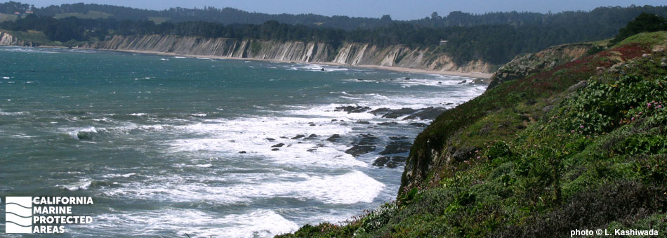
Saunders Reef State Marine Conservation Area (SMCA) sits off the rugged Mendocino Coast, four miles south of Point Arena and over 100 miles northwest of San Francisco. The marine protected area (MPA) covers a little more than nine square miles of ocean and reaches depths of more than 275 feet. The MPA contains stretches of sandy beach, rocky headlands, shallow intertidal tidepools, kelp forests, rocky reefs, and deep, sandy seafloor. The varied environments offer ample recreational activities for visitors. The area is frequented by whale and bird watchers, tidepoolers, salmon trollers, and scuba and free divers. Easy access to coastal trails and the shoreline makes Saunders Reef SMCA an ideal stop for visitors looking to experience the northern California coast.

Regulations

It is unlawful to injure, damage, take, or possess any living, geological, or cultural marine resource, EXCEPT:
Recreational and commercial take of salmon by trolling is allowed. Commercial take of urchin is allowed.

California Code of Regulations Title 14, Section 632(b)(31)(opens in new tab)

Quick Facts

MPA size: 9.36 square miles

Shoreline span: 2.5 miles

Depth range: 0 to 276 feet

Habitat composition*:

  • Rock: 5.62 square miles
  • Sand/mud: 6.57 square miles

*Habitat calculations are based on 3-dimensional area and may exceed the total MPA area listed above.

Photo Gallery

1 JUL
2022

Kayaker meets Laysan albatross, Saunders Reef SMCA

0

photo © W. Richardson, CC BY-NC 2.0

Showing 0 Comment

Video Gallery

California's MPA Network

About Saunders Reef State Marine Conservation Area

Natural History

orange sponges clinging to algae covered rock
Orange puffball sponges at Saunders Reef SMCA. photo © C. Grossman, diver.net

Saunders Reef SMCA includes stretches of sandy beach, headlands, rocky intertidal zones, nearshore reefs, and kelp forests. The headlands give way to small pocket beaches lined with beach wrack, which consists of kelp and other algae washed ashore from nearby rocky reefs, and occasional bits of driftwood. Beach wrack provides an important source of nutrients for these isolated beaches, supporting abundant and diverse invertebrate populations that are eaten by birds, fish, and other larger animals. Seals and sea lions can also be observed resting and sunning themselves on the beaches.

Saunders Reef slopes gently to an underwater rocky shelf that features several pinnacles. The reef is fully encompassed within the boundaries of the MPA and is made of bedrock, boulder fields, and gravel areas that provide cracks and crevices for various abalone species. Divers regularly see black rockfish, vermilion rockfish, and yelloweye rockfish, as well as urchins, sea stars, and Pacific giant octopus in the SMCA.

A marine mega-fossil deposit located in nearby sandstone formations provides some of the first evidence that the United States and Japan were once connected.

Cultural History

tops of kelp plants just visible under surface of ocean
Kelp forest and offshore rocks at Saunders Reef SMCA. CDFW photo by B. Owens

For centuries, Native American Tribes in California have relied on marine and coastal resources. Many Native American Tribes in California continue to regularly harvest marine resources within their ancestral territories and maintain relationships with the coast for ongoing customary uses. The Point Arena region, including the land adjacent to Saunders Reef SMCA, is the traditional territory of the Pomo, a large and diverse group of semi-nomadic people. The Pomo rely on the productive coast for their traditional diet of fish, invertebrates, and plants, with salmon and acorns as staples.

This area was frequented by Russians and native Alaskan hunters as early as 1812 and settled by Mexican landowners in the 1840s. By the 1850s, coastal towns sprang up as the fur trade grew. Point Arena’s sheltered cove offered protection from the rough Pacific, and served as a harbor for transporting timber, gold, and fish. After the Gold Rush of 1849, many former miners established ranches in the area, and lumberjacks came from New England for the region’s abundant timber resources. The fishing industry grew substantially during this period and is still a vital part of the economy at local ports.

Recreation

striated rocks protrude from water along coastline
Coastline at Saunders Reef SMCA. photo © J. McCombs, CC BY-ND 2.0

Saunders Reef SMCA offers several recreational opportunities, including whale watching, scuba diving, free diving, fishing, tidepooling, hiking, and picnicking. Coastal access is available along Highway 1 via footpaths that lead to ocean overlooks above the steep cliffs. Hikers can enjoy the isolated cliffs with unimpeded views of the ocean and ample opportunities to watch for migrating whales.

These coastal trails also connect to a steep path that drops into Saunders Landing, an old schooner mooring spot for lumber shipments in the 1800s. Hearn Gulch Beach is in the deep, protected cove at Saunders Landing, a hidden gem with heather-covered bluffs behind it and lava rock walls on both sides of the cove. A large rock off this beach features an arched tunnel.

The rocky shoreline offers tidepoolers the chance to see marine snails, sea stars, barnacles, and mussels. For anyone interested in a more immersive ocean experience, diving is allowed within Saunders Reef SMCA, but please note the challenging conditions and remoteness of the site make it appropriate only for advanced divers with experience in similar conditions. Fishermen can also enjoy the area by trolling for salmon offshore, but no other take is allowed.

Coordinates

This area is bounded by the mean high tide line and straight lines connecting the following points in the order listed except where noted:

38° 51.800 ′ N. lat. 123° 39.230 ′ W. long.;
38° 51.800 ′ N. lat. 123° 44.780 ′ W. long.; thence southward along the three nautical mile offshore boundary to
38° 50.000 ′ N. lat. 123° 42.580 ′ W. long.; and
38° 50.000 ′ N. lat. 123° 37.600 ′ W. long.

California Code of Regulations Title 14, Section 632(b)(31)

Downloads for Saunders Reef State Marine Conservation Area

Map

Map of Saunders Reef State Marine Conservation Area - click to enlarge in new tab

Facts, Map & Regulations

MPA fact sheet - click to enlarge in new tab