Santa Barbara Island State Marine Reserve/Federal Marine Reserve

island covered in green grass

Overview

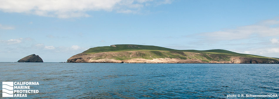
Santa Barbara Island is the smallest of the California Channel Islands, covering only one square mile in area. Nearly 13 square miles of ocean waters off the island are protected within the Santa Barbara Island State Marine Reserve (SMR), however. Where the SMR ends at three nautical miles from shore, the federal Santa Barbara Island Marine Reserve (FMR) continues farther offshore to meet the outer boundary of the surrounding Channel Islands National Marine Sanctuary.

Santa Barbara Island SMR lies on the southeastern side of the island and reaches depths greater than 1,600 feet. The SMR protects mostly sandy seafloor habitat. Fish and invertebrates such as garibaldi, rockfish, California spiny lobster, sea stars, and sea urchins are abundant in the SMR.

Most of the coastline around the island is rocky with some steep cliffs, which makes it the ideal location for animals seeking refuge, particularly nesting seabirds like California brown pelicans, cormorants, Western gulls, storm-petrels, and Scripps’ murrelet. Other notable inhabitants of the island that benefit from its protected status include northern elephant seals, California sea lions, and harbor seals.

Regulations

It is unlawful to injure, damage, take, or possess any living, geological, or cultural marine resource.

California Code of Regulations Title 14, Section 632(b)(116)(opens in new tab)

Note: The state and federal marine reserves share identical regulations.

Quick Facts

These facts are for the state marine reserve only.

MPA size: 12.77 square miles

Shoreline span: 0.8 mile

Depth range: 0 to 1,655 feet

Habitat composition*:

  • Rock: 0.74 square miles
  • Sand/mud: 2.43 square miles

*Habitat calculations are based on 3-dimensional area and may exceed the total MPA area listed above.

Photo Gallery

28 JUL
2022

Giant sea bass at Santa Barbara Island SMR

0

photo © J. Williams, CC BY-NC 2.0

Showing 0 Comment

Video Gallery

Southern California Marine Protected Area Highlights

California's MPA Network

About Santa Barbara Island State Marine Reserve/Federal Marine Reserve

Natural History

a skate swimming away past bright pink coral
Starry skate and pink gorgonian at Santa Barbara Island SMR. CDFW/MARE photo

As with the rest of the Channel Islands, Santa Barbara Island was formed by underwater volcanic activity. The island is mainly composed of volcanic rock mixed with marine sediments. This active geological history has created extensive areas of grooved, channeled, and eroded bedrock outcrops on the seafloor, which offer excellent habitat for groundfish such as rockfish, lingcod, and cabezon.

While there are no beaches on the island, coastal access is available from Landing Cove, just north of Santa Barbara Island SMR. Within the SMR, sea urchins, abalone, masking crabs, striped shore crabs, California mussels, and acorn barnacles thrive, along with kelp bass, white seabass, California sheephead, Pacific angel sharks, and California halibut.

The island is also home to the largest breeding colony of Scripps's murrelet in the United States and possibly the world. Fourteen other species of birds including brown pelicans, storm petrels, and cormorants use Santa Barbara Island to breed and raise their young.

Take of all marine resources is prohibited in the SMR and FMR.

Cultural History

closeup of a wide, bulbous shark on the sandy seafloor
Pacific angel shark at Santa Barbara Island SMR. CDFW/MARE photo

Permanent tribal settlements were likely not established on Santa Barbara Island due to the lack of fresh water and sparse terrestrial resources. However, recent evidence shows the Tongva and Chumash tribes occupied the island seasonally, most likely drawn to the island by the rich abundance of marine life inhabiting the nearshore waters.

Explorer Sebastian Vizcaino named the island when he came upon it in 1602. Ownership of Santa Barbara Island was transferred from Mexico to the United States in 1848 following the Treaty of Guadalupe Hidalgo. In 1900, the island was leased for agriculture and recreation, first to J.G. Howland in 1909. He sublet land to C.B. Linton to propagate pearls inside abalone. Alvin Hyder assumed ownership of the property in 1914, and remained on the island until 1922.

Thereafter, no activity occurred on the island until the two lighthouses were built on the island's highest peaks in 1928 and 1934. In 1938 the National Park Service established the Channel Islands National Monument, which included Anacapa and Santa Barbara islands. This protection was extended in 1949 to include one nautical mile of ocean waters extending seaward from the islands’ shorelines. In 1980, Channel Islands National Park was established, protecting Santa Rosa, Santa Cruz, and San Miguel islands in addition to Anacapa and Santa Barbara islands. The Channel Islands National Marine Sanctuary was also established in 1980, protecting 1,470 square miles of ocean waters up to six nautical miles offshore around each of the five islands.

Recreation

elephant seals on a sandy beach formed by a small cove
Northern elephant seals in a cove on Santa Barbara Island. photo © strix_v, CC BY-NC 2.0

Getting to Santa Barbara Island can be a little tricky given its remote location, however the National Park Service authorized the concessionaire Island Packers to offer boat trips to the island from April to October. Trips leave from Ventura Harbor and take approximately three hours.

On the north side of the island, overlooks such as Elephant Seal Cove and Webster Point are popular with visitors for their expansive views of the island and surrounding ocean. The southeast side of the island is popular for scuba diving and offers a chance to see seals and sea lions.

To enjoy the beauty of the reserves from the island, visitors can hike on more than five miles of trails that meander over gentle slopes and low mountain tops to National Park Service campsites, dramatic overlooks, and magnificent coastal views. The Sea Lion Rookery Trail offers spectacular views of the SMR and may allow visitors to catch a glimpse of the beaches where sea lions give birth to their pups each year from June to August. No take is allowed within the SMR or the FMR.

Coordinates

This area is bounded by the mean high tide line and straight lines connecting the following points in the order listed:

33° 28.500′ N. lat. 119° 01.813′ W. long.;
33° 28.500′ N. lat. 118° 54.527′ W. long.;
33° 21.792′ N. lat. 118° 54.527′ W. long.;
33° 21.792′ N. lat. 119° 02.200′ W. long.; and
33° 27.911′ N. lat. 119° 02.200′ W. long.

Note: This area includes Santa Barbara Island State Marine Reserve and the adjoining federal Santa Barbara Island Marine Reserve. Coordinates are provided for outer boundaries of the joined state and federal areas.

The state reserve and federal reserve share identical regulations. For state reserve boundaries only, see California Code of Regulations Title 14, Section 632. For federal reserve boundaries only, see Code of Federal Regulations, Federal Register 15 Part 922 and 50 CFR Part 660.

Downloads for Santa Barbara Island State Marine Reserve/Federal Marine Reserve

Map

Map of Santa Barbara Island SMR - click to enlarge in new tab

Facts, Map & Regulations

MPA fact sheet - click to enlarge in new tab