Gerstle Cove State Marine Reserve, and Salt Point State Marine Conservation Area

a 'sunflower star', a sea star with many legs, attached to a rock

Overview

Located about 50 miles northwest of Santa Rosa, between Fisk Mill Cove and Salt Point State Park, Salt Point State Marine Conservation Area (SMCA) protects almost two square miles of ocean ecosystems. Nestled within the SMCA, Gerstle Cove State Marine Reserve (SMR) was originally established in 1974 and is one of the oldest and smallest of California’s marine protected areas (MPAs).

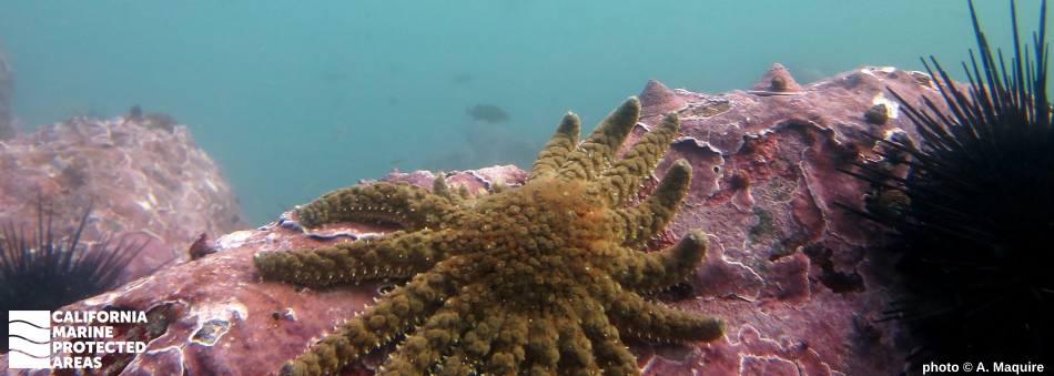
Within the SMCA, coastal bluffs and cliffs tower above rocky shores, protecting coves, offshore subtidal shelves, walls, and cobble habitats. These topographic structures provide critical habitat for species like red abalone, red sea urchin, and rockfish. The bull kelp attached to the rocky seafloor grows up to 10 inches per day, reaching for sunlight at the ocean's surface.

Gerstle Cove’s shallow depths are characterized by vibrant tidepools and sheltered rocky reefs, home to well-known species like lingcod and red abalone. These MPAs provide continuous land-sea protection and management in waters adjacent to Salt Point State Park, protecting diverse habitats in a highly scenic and relatively remote area for both consumptive and non-consumptive recreational purposes.

Regulations

Gerstle Cove SMR

It is unlawful to injure, damage, take, or possess any living, geological, or cultural marine resource.

California Code of Regulations Title 14, Section 632(b)(36)(opens in new tab)

Salt Point SMCA

It is unlawful to injure, damage, take, or possess any living, geological, or cultural marine resource, EXCEPT:
Recreational take of abalone and finfish is allowed. Please note that the abalone fishery is closed until at least 2026(opens in new tab).

California Code of Regulations Title 14, Section 632(b)(35)(opens in new tab)

Quick Facts

Gerstle Cove SMR

MPA size: 0.01 square miles

Shoreline span: 0.01 miles

Depth range: 0 to 10 feet

Habitat composition*:

  • Rock: 0.02 square miles

Salt Point SMCA

MPA size: 1.84 square miles

Shoreline span: 2.8 miles

Depth range: 0 to 226 feet

Habitat composition*:

  • Sand/mud: 0.58 square miles
  • Rock: 2.66 square miles

*Habitat calculations are based on 3-dimensional area and may exceed the total MPA area listed above.

Photo Gallery

11 AUG
2022

Fish eggs in Salt Point SMCA

0

photo © Chloe and Trevor, CC BY-NC 2.0

Showing 0 Comment

Video Gallery

California's MPA Network

About Gerstle Cove State Marine Reserve, and Salt Point State Marine Conservation Area

Natural History

rockfish swim among bull kelp
Bull kelp creates the foundation of the habitat for many species, such as these rockfish swimming among the kelp forest in Salt Point SMCA. CDFW photo by Athena Maguire

Tafoni, a type of rock cavities, are a natural phenomenon embedded in the sandstone near the ocean’s edge at Salt Point SMCA. The name Tafoni comes from the Italian word for “cavern”. Salt Point SMCA is home to rocky shores and secluded cove beaches. The intertidal zone is teeming with life such as sea stars, chitons, crabs, and aggregating anemones.

Beneath the surface, nearshore rocky reef provides ample substrate for bull kelp to attach and grow towards the ocean surface. Forests of bull kelp provide habitat for many species including blue rockfish, perch, sculpin, and cabezon. At the outer reef, the water depth increases to more than 200 feet and is interspersed by sandy and rocky seafloor. Rock walls rise up from the sandy seafloor, dotted with large anemones and encrusting sponges, while flatfish camouflage perfectly on the soft seafloor. Offshore, gray whales migrate seasonally on their journey to the Gulf of Cortez in Mexico, where they give birth in winter.

Cultural History

closeup of indigo colored tentacles extending from under reddish abalone shell
Abalone shells were an important tool for the first inhabitants who lived near Salt Point SMCA. photo © Chloe and Trevor, CC BY-NC 2.0

For centuries, Native American Tribes in California have relied on marine and coastal resources. Many Native American Tribes in California continue to regularly harvest marine resources within their ancestral territories and maintain relationships with the coast for ongoing customary uses. The Kashia Band of Pomo Indians occupied lands extending from the Gualala River to the Russian River. They thrived off deer hunting, fishing salmon, and collecting nuts, berries, greens and roots, and used abalone chisels to scrape salt off the rocks from this area. This is where the name "Salt Point" comes from.

In Gerstle Cove, harvested tanoak, hardwoods, and slabs of sandstone were loaded onto ships via cables anchored to nearshore rocks and then transported to San Francisco for building projects. During the mid-1800s, sandstone from Salt Point helped the construction of the streets and buildings of San Francisco. By 1889, only one lumber chute remained, and in 1917 the mill was completely abandoned after economic decline, leaving the land for ranching cattle. At the entrance to Salt Point State Park, you can see one of the large iron folding stock anchors that archeologists believe was used to hold a waiting vessel when the lumber mill was active. These days, this area is known for preservation of its marine and terrestrial resources.

Recreation

colorful fern-looking creatures in shallow water
Tidepooling is a popular activity in Salt Point SMCA and Gerstle Cove SMR, offering the chance to see a number of interesting creatures like these orange sea cucumbers and strawberry anemones. photo © Kevin Joe, all rights reserved

Salt Point SMCA lies adjacent to Salt Point State Park and is popular among divers, hikers, and campers. Few sandy beaches exist, but the State Park has opportunities for hiking and observing wildlife from shore.

Many tidepools are accessible during low tide, offering glimpses of nudibranchs, sea stars, urchins, limpets, and crabs. While no take is allowed in Gerstle Cove SMR, Salt Point SMCA is a popular spot for surf fishing, with take of finfish allowed within the MPA.


Coordinates

Gerstle Cove SMR

This area lies within the Salt Point State Marine Conservation Area and is bounded by the mean high tide line and a straight line connecting the following points:

38o 33.950 ′ N. lat. 123o 19.920′ W. long.; and
38o 33.950 ′ N. lat. 123o 19.760′ W. long.

California Code of Regulations Title 14, Section 632(b)(36)

Salt Point SMCA

This area is bounded by the mean high tide line and straight lines connecting the following points in the order listed:

38o 35.600 ′ N. lat. 123o 20.800′ W. long.;
38o 35.600 ′ N. lat. 123o 21.000′ W. long.;
38o 33.500 ′ N. lat. 123o 21.000′ W. long.; and
38o 33.500′ N. lat. 123o 18.910′ W. long., except that Gerstle Cove as described in subsection 632(b)(36)(A) is excluded.

California Code of Regulations Title 14, Section 632(b)(35)

Downloads for Gerstle Cove State Marine Reserve

Map

Map of Gerstle Cove State Marine Reserve - click to enlarge in new tab

Facts, Map & Regulations

MPA fact sheet - click to enlarge in new tab

Downloads for Salt Point State Marine Conservation Area

Map

Map of Salt Point State Marine Conservation Area - click to enlarge in new tab

Facts, Map & Regulations

MPA fact sheet - click to enlarge in new tab