Richardson Rock State Marine Reserve/Federal Marine Reserve

ocean splashing against a broad rock island

Overview

Richardson Rock State Marine Reserve (SMR) and the federal Richardson Rock Marine Reserve (FMR) are located northwest of San Miguel Island, the westernmost of California’s Channel Islands. The SMR covers nearly 41 square miles of ocean, and where the SMR ends at three nautical miles from shore, the FMR continues farther offshore to meet the outer boundary of the surrounding Channel Islands National Marine Sanctuary. 

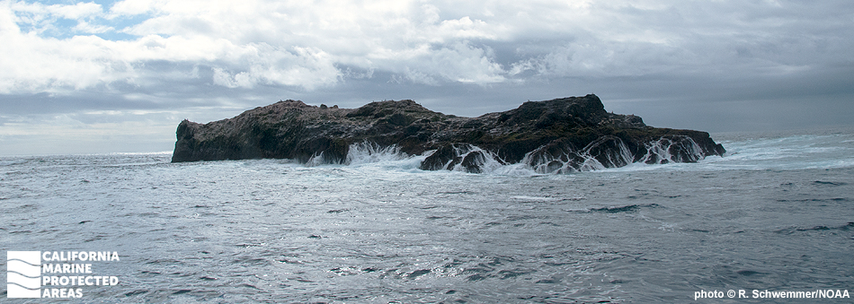
Richardson Rock SMR and FMR are located in open water at the western boundary of the sanctuary. Roughly six miles from San Miguel Island, the massive Richardson Rock rises abruptly out of deep water. A spectacular pinnacle, it draws adventurous divers who are willing to brave the often stormy seas to see the incredible ecosystem in this marine protected area (MPA). Steep walls, drop-offs, large holes, and pinnacles provide shelter for invertebrates like white-spotted rose anemones, scallops, tubeworms, and barnacles, as well as octopus, lingcod, vermilion rockfish, and wolf-eels. Seals and sea lions visit this remote islet to hunt the rockfish schooling near its rocky pinnacles.

Regulations

It is unlawful to injure, damage, take, or possess any living, geological, or cultural marine resource.

California Code of Regulations Title 14, Section 632(b)(101)(opens in new tab)

Note: The state and federal marine reserves share identical regulations.

Quick Facts

These facts are for the state marine reserve only.

MPA size: 40.75 square miles

Depth range: 0 to 558 feet

Habitat composition*:

  • Rock: 0.13 square miles
  • Sand/mud: 0.68 square miles

*Habitat calculations are based on 3-dimensional area and may exceed the total MPA area listed above.

Photo Gallery

31 AUG
2022

Black-footed albatross at Richardson Rock SMR

0

photo © B. Johnson, CC BY-NC 2.0

Showing 0 Comment

Video Gallery

Southern California Marine Protected Area Highlights

California's MPA Network

About Richardson Rock State Marine Reserve/Federal Marine Reserve

Natural History

flying seabird
Sabine's gull at Richardson Rock SMR. photo © O. Johnson, CC BY-NC-ND 2.0

The Northern Channel Islands were formed by tectonic forces millions of years ago. The islands are the visible part of a submarine ridge created by those forces. Richardson Rock is unique in that it is the most apparent western extension of that submarine ridge.

From the surface, Richardson Rock often looks like two separate rocks, with the smaller of the two on the southeast side. Only during low tide is the jagged ridge that joins these rocks visible above the sea surface. Many different habitat types are found below the surface, including sandy and rocky seafloor areas with reefs and large rocky outcroppings. The sheer, vertical rock walls of Richardson Rock plunge below the rough seas into the surrounding waters to depths of over 550 feet.

The many crevices at Richardson Rock create ideal habitat for countless marine animals. Invertebrates like sea stars, sea anemones and nudibranchs can be found gripping the rock walls. Lingcod, white seabass, and sizeable schools of rockfish flourish in these protected waters.

Cultural History

ocean splashing against a broad rock island
Richardson Rock. photo © R. Schwemmer/NOAA

Permanent tribal settlements were likely not established at Richardson Rock due to the extremely rocky terrain, lack of fresh water, and few terrestrial resources. However, native Chumash peoples resided within the greater Channel Islands for thousands of years and relied heavily on the ocean for food and resources. With easy access to the sea, they ate a variety of marine mammals like sea otters and sea lions as well as rockfish, barnacles and mussels. As skilled craftsmen, the Chumash built long redwood canoes called tomols that allowed them to venture far offshore.

Richardson Rock has been a known boating hazard since as far back as the 1600s. It is named for Nathan Richardson, who saved himself after an 1851 shipwreck by managing to make it onto the rock where he waited to be rescued. The rocky islet is subject to strong currents, intense winds, and big swells from the north, and still poses a serious hazard to sailors today.

Richardson Rock is located within the boundaries of the Channel Islands National Marine Sanctuary, which was established in 1980. The Channel Islands National Marine Sanctuary protects 1,470 square miles of ocean, and provides another layer of protection for the waters of Richardson Rock SMR and FMR.

Recreation

large, flying seabird
Black-footed albatross at Richardson Rock SMR. photo © A. Searcy, CC BY-NC 2.0

These treacherous waters are popular among adventurous scuba divers who come to view its abundant marine life. With rocky walls colonized by a great many kelp and invertebrate species, and rocky ridges, holes, and crevices for fish to hide in, Richardson Rock provides important habitat for countless marine plants and animals. While calm days are rare, divers can occasionally witness colorful sea urchins and sea stars plastered to the rock walls, vermilion rockfish darting by, and sea lions hunting near Richardson Rock. The current can be strong and the best dives are typically in deeper water, so this MPA is better suited to advanced divers.

Fishing is not permitted within state and federal marine reserves, but one can view wildlife from below the surface or from a boat. About six miles away, beautiful and isolated San Miguel Island receives fewer visitors than the other Channel Islands. Hikers and tourists can visit San Miguel Island to see wildlife including brown pelicans, peregrine falcons, island foxes, harbor seals, northern elephant seals and California sea lions.

Coordinates

This area is bounded by the mean high tide line of Richardson Rock and straight lines connecting the following points in the order listed:

34° 02.211' N. lat. 120° 28.200' W. long.;
34° 02.211' N. lat. 120° 36.290' W. long.;
34° 10.400' N. lat. 120° 36.290' W. long.;
34° 10.400' N. lat. 120° 28.200' W. long.; and
34° 02.211' N. lat. 120° 28.200' W. long.

Note: This area includes Richardson Rock State Marine Reserve and the adjoining federal Richardson Rock Marine Reserve. Coordinates are provided for outer boundaries of the joined state and federal areas.

The state reserve and federal reserve share identical regulations. For state reserve boundaries only, see California Code of Regulations Title 14, Section 632. For federal reserve boundaries only, see Code of Federal Regulations, Federal Register 15 Part 922 and 50 CFR Part 660.

Downloads for Richardson Rock State Marine Reserve/Federal Marine Reserve

Map

Map of Richardson Rock SMR - click to enlarge in new tab

Facts, Map & Regulations

MPA fact sheet - click to enlarge in new tab