Point Reyes State Marine Reserve/State Marine Conservation Area, and Point Reyes Headlands Special Closure

a high, thin ridge connects a plateau topped with cypress trees to the mainland

Overview

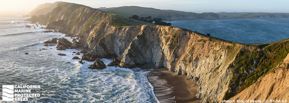
Point Reyes State Marine Reserve (SMR), Point Reyes State Marine Conservation Area (SMCA), and Point Reyes Headlands Special Closure are located off the southwestern shoreline of Point Reyes. These two marine protected areas (MPAs) and one special closure lie 30 miles northwest of the Golden Gate Bridge, in Marin County. Surrounding the southern and leeward side of the Point Reyes Peninsula, the SMR protects more than 9½ square miles of ocean habitat, including sandy beaches, rocky shores, surfgrass and eelgrass beds, tidal flats, rocky reefs, and sandy seafloor to depths exceeding 130 feet.

Point Reyes SMCA protects more than 12 square miles of mostly sandy seafloor and rocky bottom habitats to depths greater than 200 feet. Point Reyes Headlands Special Closure is a narrow strip along the headlands that spans from the lighthouse to the outer edge of Drakes Bay. Extending 1,000 feet from the base of the headlands, the special closure protects sandy beaches, rocky shores and reefs, and extensive surfgrass beds.

The Point Reyes SMR and SMCA are used by gray whales, Steller sea lions, northern elephant seals, common murres, pigeon guillemots, Brandt’s cormorants, blue rockfish, brown rockfish, canary rockfish, sculpin, sea stars, sea cucumbers, Dungeness crab, and red octopus, among other species. The special closure safeguards Brandt's and pelagic cormorants, western gulls, common murres, pigeon guillemots, rhinoceros auklet, ashy storm-petrel, and brown pelicans from flushing and/or abandoning nests when disturbed. The Point Reyes MPAs and special closure and their surrounding areas include popular destinations for beachgoers, hikers, wildlife enthusiasts, and hardy surfers.

Regulations

Point Reyes SMR

It is unlawful to injure, damage, take, or possess any living, geological, or cultural marine resource.

California Code of Regulations Title 14, Section 632(b)(43)(opens in new tab)

Point Reyes SMCA

It is unlawful to injure, damage, take, or possess any living, geological, or cultural marine resource, EXCEPT:

Recreational and commercial take of salmon by trolling and Dungeness crab by trap is allowed.

California Code of Regulations Title 14, Section 632(b)(44)(opens in new tab)

Point Reyes Headlands Special Closure

Boating and access are restricted. No person except employees of the California Department of Fish and Wildlife, United States Fish and Wildlife Service, National Park Service, or United States Coast Guard during performance of their official duties, or unless permission is granted by the California Department of Fish and Wildlife, shall enter the area.

California Code of Regulations Title 14, Section 632(b)(45)(opens in new tab)

Quick Facts

Point Reyes SMR

MPA size: 9.55 square miles

Shoreline span: 6.4 miles

Depth range: 0 to 132 feet

Habitat composition*:

  • Rock: 9.59 square miles
  • Sand/mud: 8.53 square miles

Point Reyes SMCA

MPA size: 12.27 square miles

Depth range: 51 to 217 feet

Habitat composition*:

  • Rock: 0.08 square miles
  • Sand/mud: 12.23 square miles

Point Reyes Headlands Special Closure

Special Closure size: 0.67 square miles

Depth range: 0 to 40 feet

Habitat composition*:

  • Rock: 1.21 square miles
  • Sand/mud: 0.17 square miles

*Habitat calculations are based on 3-dimensional area and may exceed the total MPA area listed above.

Photo Gallery

27 SEP
2022

Elephant seal in Point Reyes SMR

0

photo © Eric, CC BY-NC 2.0

Showing 0 Comment

Video Gallery

California's MPA Network

Western Snowy Plover - Saving Species Together

Chorlito nevado occidental - Salvemos especies juntos

About Point Reyes State Marine Reserve/State Marine Conservation Area, and Point Reyes Headlands Special Closure

Natural History

large piles of tangled seaweed on the seashore
Bull kelp and giant kelp beach wrack at Point Reyes SMR. photo © E. Wing, CC BY-NC 2.0

The cluster of Point Reyes MPAs and special closure, along with the terrestrial protection afforded by the Point Reyes National Seashore creates an expansive land-sea conservation area. From its open grasslands, to freshwater creeks and tributaries leading to the Pacific, and large stretches of sand beach that intersect with rocky shoreline and surfgrass meadows, Point Reyes contains a unique variety of habitats at the end of this peninsula.

The rugged cliffs between the Point Reyes Lighthouse and Chimney Rock hint at the rocky reefs below. Underwater, rocky outcroppings and sandy seafloor cover most of the offshore MPA area. From the shallow brackish estuaries to the offshore waters, these MPAs and special closure host many endangered, as well as recreationally important species of plants, animals, and fish. Several species of marine mammals, notably gray whales, northern elephant seals, and Steller sea lions, share these waters with numerous fishes, including various species of surfperch and rockfish. Invertebrates like Dungeness crab, coonstripe shrimp, anemones, sea whips, and sea pens are common occupants of the deeper offshore areas.

Point Reyes National Seashore, which includes approximately 71,000 acres on the Point Reyes peninsula, contains the highest diversity of bird species of any protected land in the U.S. An astounding 490 species, or 54 percent of all North American bird species, have been recorded in the Point Reyes area. These include fish-eating common murres, brown pelicans, and cormorants.

Cultural History

two cockle shells lying in fine sand
Nuttall's cockle shells in Point Reyes Headlands Special Closure. photo © L. Zentall, CC BY-NC 2.0

For centuries, Native American Tribes in California have relied on marine and coastal resources. Many Native American Tribes in California continue to regularly harvest marine resources within their ancestral territories and maintain relationships with the coast for ongoing customary uses. Point Reyes has a long history of human occupation, including the Coast Miwok whose presence on the peninsula stretches back thousands of years.

The traditional Coast Miwok diet consists of several species of fish including halibut and rockfish, and invertebrates such as crabs, clams, mussels, abalone and oysters. Kule Loklo, a replica Miwok village run jointly by members of the Coast Miwok and California State Parks, is located near Point Reyes National Seashore's Bear Valley Visitor Center. The first European landing in northern California occurred on June 17, 1579 on the southern side of Point Reyes, now known as Drakes Estero, by the Sir Francis Drake Expedition. Originally used as a safe harbor for trading vessels, the fertile land soon became home to Spanish settlement during the Missionary period until Mexico gained its independence from Spain in 1821.

Point Reyes was then used as ranchland and dairy pasture, undergoing several ownership changes until 1962, when it was purchased by the National Park Service for conservation purposes. An automated lighthouse was installed by the U.S. Coast Guard below the historic Point Reyes Lighthouse in 1975. There is now a visitor center open to the public and maintained by the National Park Service.

Recreation

a lighthouse positioned on a clifftop above the sea
Point Reyes Lighthouse, overlooking Point Reyes SMR. photo © F. Schulenburg, CC BY-NC 2.0

The Point Reyes peninsula and the adjacent MPAs and special closure are ideal locations to appreciate the natural beauty of the surrounding land and seascape. Extensive recreational activities include hiking, biking, kayaking, camping, and wildlife viewing. Marine mammal enthusiasts will find sea lions year-round, elephant seals on the beaches, and migrating whales offshore during the spring. The great diversity and abundance of birds protected by the special closure makes the Point Reyes Headlands a popular location for birdwatching.

For land-based visitors, parking and bathrooms are available at the Point Reyes Lighthouse and Chimney Rock, and a visitor center is located at the lighthouse. Nearly all of Point Reyes is protected as a National Seashore. Take of all living marine resources is prohibited within the SMR and access is prohibited in the special closure. Within the SMCA, fishermen can try their hand at catching Dungeness crab by trap and salmon by trolling, but no other marine resources may be taken from within the SMCA.

Coordinates

Point Reyes SMR

This area is bounded by the mean high tide line and straight lines connecting the following points in the order listed:

37° 59.900′ N. lat. 123° 01.278′ W. long.;
37° 59.900′ N. lat. 123° 02.000′ W. long.;
37° 59.000′ N. lat. 123° 02.000′ W. long.;
37° 59.000′ N. lat. 122° 57.340′ W. long.; and
38° 01.750′ N. lat. 122° 55.000′ W. long.; thence westward along the mean high tide line onshore boundary to
38° 01.783′ N. lat. 122° 55.286′ W. long.; and
38° 01.941′ N. lat. 122° 56.364′ W. long.

California Code of Regulations Title 14, Section 632(b)(43)

Point Reyes SMCA

This area is bounded by straight lines connecting the following points in the order listed except where noted:

37° 59.000′ N. lat. 123° 02.000′ W. long.;
37° 56.712′ N. lat. 123° 02.000′ W. long.; thence eastward along the three nautical mile offshore boundary to
37° 56.370′ N. lat. 122° 57.340′ W. long.;
37° 59.000′ N. lat. 122° 57.340′ W. long.; and
37° 59.000′ N. lat. 123° 02.000′ W. long.

California Code of Regulations Title 14, Section 632(b)(44)

Point Reyes Headlands Special Closure

A special closure is designated on the south side of the Point Reyes Headlands from the mean high tide line to a distance of 1,000 feet seaward of the mean lower low tide line of any shoreline between lines extending due south from each of the following two points:

37° 59.650′ N. lat. 123° 01.000′ W. long; and
37° 59.390′ N. lat. 122° 57.800′ W. long.

California Code of Regulations Title 14, Section 632(b)(45)

Downloads for Point Reyes State Marine Reserve

Map

Map of Point Reyes State Marine Reserve - click to enlarge in new tab

Facts, Map & Regulations

MPA fact sheet - click to enlarge in new tab

Downloads for Point Reyes State Marine Conservation Area

Map

Map of Point Reyes State Marine Conservation Area - click to enlarge in new tab

Facts, Map & Regulations

MPA fact sheet - click to enlarge in new tab

Downloads for Point Reyes Headlands Special Closure

Map

Map of Point Reyes Special Closure - click to enlarge in new tab

Facts, Map & Regulations

MPA fact sheet - click to enlarge in new tab