Point Dume State Marine Reserve/State Marine Conservation Area

a curved beach follows a coastal promontory

Overview

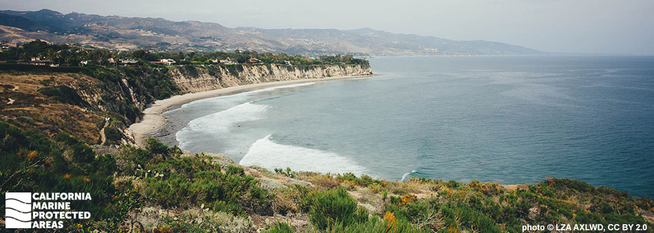
Point Dume State Marine Reserve (SMR) and Point Dume State Marine Conservation Area (SMCA) are adjacent marine protected areas (MPAs) located along the coastline off Malibu in Los Angeles County. These MPAs hug the Point Dume promontory, a coastal flatland bluff that juts south into the Pacific Ocean and forms the northern end of Santa Monica Bay.

Point Dume SMR, which covers more than 7½ square miles off the tip of Point Dume, extends to depths of nearly 2,000 feet. The SMR protects an expanse of sandy beach, rocky shores, kelp forests, surfgrass beds, an upwelling zone, and nearly two square miles of deep submarine canyon.

Point Dume SMCA, the larger of the two MPAs, protects nearly 16 square miles extending to depths greater than 2,000 feet. The SMCA protects an expanse of sandy beach and seafloor habitat, rocky shores, kelp forests, surfgrass beds, an upwelling zone, and less than a quarter square mile of deep submarine canyon, which together create an area of high biodiversity. The SMCA also provides for excellent surfing, diving, tidepooling, and whale watching opportunities.

Regulations

Point Dume SMR

It is unlawful to injure, damage, take, or possess any living, geological, or cultural marine resource.

California Code of Regulations Title 14, Section 632(b)(118)(opens in new tab)

Point Dume SMCA

It is unlawful to injure, damage, take, or possess any living, geological, or cultural marine resource, EXCEPT:
Recreational take of white seabass and pelagic finfish (northern anchovy, barracudas, billfishes, dorado (dolphinfish), Pacific herring, jack mackerel, Pacific mackerel, salmon, Pacific sardine, blue shark, salmon shark, shortfin mako shark, thresher shark, swordfish, tunas, Pacific bonito, and yellowtail) by spearfishing is allowed.

Commercial take of coastal pelagic species (northern anchovy, Pacific sardine, Pacific mackerel, jack mackerel, and market squid) by round-haul net, brail gear, and light boat; and swordfish by harpoon is allowed. Not more than five percent by weight of any commercial coastal pelagic species catch landed or possessed shall be other incidentally taken species. Includes take exemptions for the following tribe:

  • Santa Ynez Band of Chumash Indians

California Code of Regulations Title 14, Section 632(b)(117)(opens in new tab)

Quick Facts

Point Dume SMR

MPA size: 7.53 square miles

Shoreline span: 2.9 miles

Depth range: 0 to 1,987 feet

Habitat composition*:

  • Rock: 0.50 square miles
  • Sand/mud: 7.27 square miles

Point Dume SMCA

MPA size: 15.92 square miles

Shoreline span: 4 miles

Depth range: 0 to 2,023 feet

Habitat composition*:

  • Rock: 0.33 square miles
  • Sand/mud: 15.71 square miles

*Habitat calculations are based on 3-dimensional area and may exceed the total MPA area listed above.

Photo Gallery

22 AUG
2022

Surfgrass in the rocks at low tide, Point Dume SMCA

0

photo © T. Quinn CC BY-NC 2.0

Showing 0 Comment

Video Gallery

Dive Deep with a Remotely Operated Vehicle: Point Dume State Marine Reserve

Southern California Marine Protected Area Highlights

California's MPA Network

About Point Dume State Marine Reserve/State Marine Conservation Area

Natural History

two silver fish
Sargos in the Point Dume SMR. photo © JeffS, CC BY-NC 2.0

Sandwiched between peaks of the Santa Monica Mountains, Point Dume allows visitors to view the Santa Monica Mountains looking landward, while looking offshore visitors may see the Channel Islands. Offshore, cold, nutrient-rich water is funneled up from the depths of the Pacific Ocean through a submarine canyon (a deep, underwater valley). This nutrient-rich water enriches the entire marine food chain, from low-level producers such as algae and zooplankton, to high level predators including sand sharks, bottlenose dolphins, and gray whales.

The varied seafloor topography of these MPAs includes hills, valleys, grooves, and channels that provide excellent habitat for white seabass, giant sea bass, kelp bass, and lobster. Harbor seals, sea lions, and dolphins are common visitors, and during spring and fall, humpback and gray whales are frequently sighted as they migrate along the coast.

Along the shore, volcanic rock weathers more slowly than the surrounding sedimentary stone, forming an elaborate network of shallow tidepools where crabs, urchins, mussels, octopus, and small fish like sculpin and juvenile garibaldi hide when the tide recedes.

Cultural History

tide pools at sunset
Tidepools in the Point Dume SMR and SMCA. © photo by Pacheco, CC BY-ND 2.0

For centuries, Native American Tribes in California have relied on marine and coastal resources. Many Native American Tribes in California continue to regularly harvest marine resources within their ancestral territories and maintain relationships with the coast for ongoing customary uses. The Chumash have lived along the Malibu coast for thousands of years and used Point Dume as a sacred place to worship the sun. The plentiful natural resources around Point Dume nourished the Chumash, allowing them to develop societies of great complexity and adaptability.

Point Dume was an invaluable navigational marker for early explorers. In 1572, Spanish explorer Juan Rodriguez Cabrillo noted Point Dume in his logbooks. The point was named in 1793 when British explorer George Vancouver honored a priest, Father Francisco Dumetz.

During World War II, the United States Army used Point Dume as an anti-aircraft artillery training site. Beginning in the 1940s, Point Dume and the adjacent Malibu coast underwent major commercial development. Eventually, the point’s historical and environmental importance was acknowledged, and it was acquired by the state government in 1973. Rigorous conservation legislation and community efforts have successfully restored much of Point Dume.

Recreation

surfer on a wave
A surfer riding a wave at the edge of Point Dume State Beach. photo © Vladimir Kudinov, CC0

The Point Dume MPAs offer a variety of recreational and educational opportunities such as kayaking, tidepooling, diving, and surfing. Whale watching is a popular activity and gray whales may be spotted from the beach during their December-April migration period. On clear days, visitors hiking along the bluffs have an expansive view of Santa Monica Bay, the Malibu coast, and Catalina Island, and may see sea lions, harbor seals, and a variety of dolphin species.

Moving off the bluffs and closer to the water’s edge during low tides, sea stars, octopus, crabs, anemones, and many other intertidal organisms are found in the tidepools. Remember to tread lightly on rocks to avoid stepping on marine life, and leave animals in their homes. Point Dume is popular among experienced surfers who enjoy a point break. Advanced scuba divers can explore the pinnacles in Point Dume SMR.

The adjacent Point Dume State Beach and Natural Preserve provide easy access to the MPAs. Both free and paid parking are available along Westward Beach Road and free shuttles run during weekends, holidays, and summer months from Westward Beach Road to the Point Dume Natural Preserve trailhead.

Take of all marine resources is prohibited within the Point Dume SMR. In the SMCA, white seabass and pelagic finfish may be taken recreationally by spear.

Coordinates

Point Dume SMR

This area is bounded by the mean high tide line and straight lines connecting the following points in the order listed except where noted:

34o 00.780 ′ N. lat. 118o 49.200 ′ W. long.;
33o 56.960 ′ N. lat. 118o 49.200 ′ W. long.; thence eastward along the three nautical mile offshore boundary to
33o 57.061 ′ N. lat. 118o 47.260 ′ W. long.; and
34o 01.178 ′ N. lat. 118o 47.260 ′ W. long.

California Code of Regulations Title 14, Section 632(b)(118)

Point Dume SMCA

This area is bounded by the mean high tide line and straight lines connecting the following points in the order listed except where noted:

34o 02.306 ′ N. lat. 118o 53.000 ′ W. long.;
33o 59.140 ′ N. lat. 118o 53.000 ′ W. long.; thence southeastward along the three nautical mile offshore boundary to
33o 56.960 ′ N. lat. 118o 49.200 ′ W. long.; and
34o 00.780 ′ N. lat. 118o 49.200 ′ W. long.

California Code of Regulations Title 14, Section 632(b)(117)

Downloads for Point Dume State Marine Reserve

Map

Map of Point Dume State Marine Reserve - click to enlarge in new tab

Facts, Map & Regulations

MPA fact sheet - click to enlarge in new tab

Downloads for Point Dume State Marine Conservation Area

Map

Map of Point Dume State Marine Conservation Area - click to enlarge in new tab

Facts, Map & Regulations

MPA fact sheet - click to enlarge in new tab