Painted Cave State Marine Conservation Area

people on a boat look into a large sea cave

Overview

Painted Cave State Marine Conservation Area (SMCA) sits near the northwest end of Santa Cruz Island, the largest of California’s Channel Islands, south of Santa Barbara on the mainland. Protecting nearly two square miles of nearshore ecosystems, this marine protected area (MPA) is home to rocky shores, sandy seafloor habitat, and offshore rocky reefs.

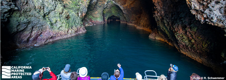
The most notable feature along the predominantly rocky shoreline is Painted Cave, the largest sea cave in North America. Exploring the spectacular cave in a boat or kayak is a truly memorable experience. The SMCA's rocky shoreline provides habitat for shore and seabirds, such as brown pelicans and pelagic cormorants. Invertebrates like mussels, anemones, and barnacles can be spotted in the rocky intertidal area.

Fed by cold, nutrient-rich, upwelled waters from the California Current, the MPA protects a highly productive environment that attracts both cold- and warm-water species. Highly migratory pelagic fish like tuna and mackerel, pinnipeds like sea lions and seals, fish such as kelp bass, giant sea bass, and California sheephead, and the iconic Southern California invertebrate, California spiny lobster, can all be found in the SMCA. Although not out of reach, visiting this MPA requires a one-hour boat ride from Ventura Harbor.

Regulations

It is unlawful to injure, damage, take, or possess any living, geological, or cultural marine resource, EXCEPT:

Recreational take of lobster and pelagic finfish (northern anchovy, barracudas, billfishes, dorado (dolphinfish), Pacific herring, jack mackerel, Pacific mackerel, salmon, Pacific sardine, blue shark, salmon shark, shortfin mako shark, thresher shark, swordfish, tunas, Pacific bonito, and yellowtail) is allowed.

California Code of Regulations Title 14, Section 632(b)(108)(opens in new tab)

Quick Facts

MPA size: 1.78 square miles

Shoreline span: 2.2 miles

Depth range: 0 to 291 feet

Habitat composition*:

  • Rock: 0.04 square miles
  • Sand/mud: 0.17 square miles

*Habitat calculations are based on 3-dimensional area and may exceed the total MPA area listed above.

Photo Gallery

17 JUN
2022

Black-and-yellow rockfish at Painted Cave SMCA

0

Photo © sea-kangaroo BY-NC-ND-2.0

Showing 0 Comment

Video Gallery

Southern California Marine Protected Area Highlights

California's MPA Network

About Painted Cave State Marine Conservation Area

Natural History

red sea urchin
Red sea urchin in Painted Cave SMCA. photo © sea-kangaroo, CC BY-NC 2.0

Much of the shoreline of Painted Cave SMCA is comprised of steep rocky cliffs that drop precipitously into the Pacific, creating a narrow intertidal zone that cascades sharply into the depths. The rocky shores extend underwater with sheer rugged faces, ledges, and crevices that create sheltered habitat for marine life. Sea stars and a variety of anemones including pink strawberry, white spotted rose, and giant green anemones attach to the rocky substrate. Mussels and barnacles are prominent, and fish such as lingcod and treefish hunt for easy meals throughout the rocky underwater landscape.

Divers may encounter an occasional bright orange garibaldi guarding its territory. Seasonally migrating yellowtail, barracuda, and bonito may be observed in open waters farther offshore, as well as gray, blue, and humpback whales.

Painted Cave gets its name from the colorful rocks, lichens, and algae lining the cave walls, creating a natural, multihued fresco. One of the largest sea caves in the world, it stretches 1,227 feet inland, the length of more than four football fields. The entrance is 100 feet wide with a 160-foot ceiling, allowing larger boats to enter. During springtime, a waterfall pours over the entrance. Harbor seals, sea lions, and various birds frequently seek shelter inside the cave. About two-thirds of the way in, the cave narrows and enters a large chamber. Barking sea lions rest on a rocky beach within the pitch-black chamber.

Cultural History

deep sea cave with multiple chambers and colorful walls
Sea cave entrance in Painted Cave SMCA. photo © Charles Wohlers, CC BY-NC-ND 2.0

For centuries, Native American Tribes in California have relied on marine and coastal resources. Many Native American Tribes in California continue to regularly harvest marine resources within their ancestral territories and maintain relationships with the coast for ongoing customary uses. Chumash people occupied Santa Cruz Island for at least 9,000 years. They used the tomol, a traditional redwood plank canoe, to travel between the islands and mainland.

During a visit by Europeans in 1769, the earliest recorded European visit to the island, Spanish explorers realized they had left an iron staff cross at a local Chumash village. Considering it lost, they were surprised the next day when a tomol arrived at their ship to return the forgotten staff. Upon receiving the staff, the Europeans named the island Santa Cruz, meaning “Island of the Holy Cross.”

Through a land grant from the Mexican government, Captain Andres Castillero became the first private owner of Santa Cruz Island in 1839. He then sold it in 1857 to William Barron, a San Francisco businessman, who started a sheep operation there. By 1886 Justinian Caire, a French immigrant, acquired all the shares of the Santa Cruz Island Company and started a self-sustaining sheep and cattle ranch, vineyard, and nut and fruit grove on the island. Upon Caire’s death, a hotly contested land dispute began a decades-long legal battle over the Santa Cruz Island Company. The legal fight was finally resolved and the property transferred to The Nature Conservancy in the 1990s.

Channel Islands National Park now owns and operates approximately 24 percent of Santa Cruz Island, and The Nature Conservancy, the University of California Natural Reserve System, and the Santa Cruz Island Foundation operate the remainder. Much of the island is dedicated to scientific research and education focusing on marine and terrestrial studies. In 1980, Channel Islands National Park was established, protecting Santa Rosa, Santa Cruz, and San Miguel islands in addition to Anacapa and Santa Barbara islands. Only Anacapa and Santa Barbara islands had previously been protected as part of the Channel Islands National Monument. The Channel Islands National Marine Sanctuary was also established in 1980, protecting 1,470 square miles of ocean, and encompassing the waters up to six nautical miles offshore around each of the five islands.

Recreation

view of pointed hills on the shoreline through rope boat rigging
View of Santa Cruz Island's Painted Cave SMCA. photo © Dave-Proffer, CC BY-NC-SA 2.0

Santa Cruz Island is the perfect place for a day trip or multi-night camping trip. Of the Northern Channel Islands, it is one of the easiest to access by boat. Leaving from Ventura Harbor, public trips to the island with the National Park Service-authorized concessionaire, Island Packers, take about one hour. Along the way it is common to see whale spouts, pods of dolphins, and many different seabirds.

The Channel Islands National Park visitors center on Santa Cruz Island is located in the Scorpion Ranch House, where they have a variety of interactive exhibits and resources to help you learn more about the island's history. On a calm day, snorkelers can drift along the coastline and within tidepools in search of marine life. Farther offshore, in deeper waters, scuba divers can explore large rocky reefs. Visibility is frequently good here, occasionally reaching 100 feet. Close encounters with curious seals and playful sea lions are common, and divers should expect to see plenty of fish and colorful invertebrates.

Painted Cave is an incredible site to visit and many charter boats will enter the front end of the cave on a trip to the island. Kayak tours can take one farther into the cave to fully experience the pitch-black chamber, echoing with the barks of sea lions.

Take of all living marine resources is prohibited within Painted Cave SMCA except for the recreational take of spiny lobster and pelagic finfish.

Coordinates

This area is bounded by the mean high tide line and straight lines connecting the following points in the order listed except where noted:

34° 04.492' N. lat. 119° 53.000' W. long.;
34° 05.200' N. lat. 119° 53.000' W. long; thence eastward along a line one nautical mile offshore to

34° 05.000' N. lat. 119° 51.000' W. long.; and
34° 04.034' N. lat. 119° 51.000' W. long.

California Code of Regulations Title 14, Section 632(b)(108)

Downloads for Painted Cave State Marine Conservation Area

Map

Map of Painted Cave State Marine Conservation Area - click to enlarge in new tab

Facts, Map & Regulations

MPA fact sheet - click to enlarge in new tab