Asilomar State Marine Reserve, and Pacific Grove Marine Gardens State Marine Conservation Area

a unique rock structure with striated formations creating an arch at the shoreline

Overview

Pacific Grove Marine Gardens State Marine Conservation Area (SMCA) and Asilomar State Marine Reserve (SMR) are two of four marine protected areas (MPAs) located on the Monterey Peninsula. The SMCA spans almost 1½ miles of coastline between Lovers Point and Point Pinos, and reaches depths of around 150 feet. Although less than one square mile in total area, this MPA is popular for its rocky beaches, beautiful ocean vistas, tidepools, and kelp forests.

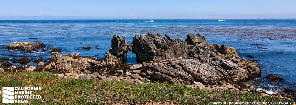
Spanning roughly two miles of shoreline from Point Joe to Point Pinos, Asilomar SMR encompasses about 1½ square miles of sandy beaches, rocky intertidal shores, surfgrass beds, kelp forests, and sandy and rocky seafloor habitats to depths of more than 170 feet.

While exposure to the open ocean creates hazardous conditions for kayaking, diving is popular here on calm days. A coastal walking path offers expansive views of Monterey Bay and its coastline. Low tide reveals tidepools filled with an abundance of sea stars, anemones, sculpins, bat stars, crabs, limpets and nudibranchs. The vibrant kelp forests near shore provide refuge for many small invertebrates and fish. Marine mammals like sea lions and harbor seals can be seen sprawling across the rocky shores and harbor porpoises move gracefully through the cold, nutrient-rich nearshore waters.

Regulations

Asilomar SMR

It is unlawful to injure, damage, take, or possess any living, geological, or cultural marine resource.

California Code of Regulations Title 14, Section 632(b)(78)(opens in new tab)

Pacific Grove Marine Gardens SMCA

It is unlawful to injure, damage, take, or possess any living, geological, or cultural marine resource, EXCEPT:

Recreational take of finfish is allowed. Commercial take of giant kelp and bull kelp by hand is allowed.

California Code of Regulations Title 14, Section 632(b)(77)(opens in new tab)

Quick Facts

Asilomar SMR

MPA size: 1.51 square miles

Shoreline span: 2.3 miles

Depth range: 0 to 172 feet

Habitat composition*:

  • Sand/mud: 0.55 square miles
  • Rock: 2.32 square miles

Pacific Grove Marine Gardens SMCA

MPA size: 0.98 square miles

Shoreline span: 1.3 miles

Depth range: 0 to 151 feet

Habitat composition*:

  • Sand/mud: 0.32 square miles
  • Rock: 1.49 square miles

*Habitat calculations are based on 3-dimensional area and may exceed the total MPA area listed above.

About Asilomar State Marine Reserve, and Pacific Grove Marine Gardens State Marine Conservation Area

Natural History

two long-beaked, long-legged birds stand on a rock at the shoreline
Whimbrels in Asilomar SMR. photo © N. Siemers, CC BY-NC 2.0

The Monterey Canyon is located near both of these MPAs. This deep submarine canyon reaches nearly 12,000 feet at its deepest point, almost twice as deep as the Grand Canyon. Upwelling causes cold, nutrient-rich waters to rise from the depths of the canyon into the MPAs and the surrounding area, creating a remarkably productive ecosystem. The nutrient-rich waters teem with phytoplankton and zooplankton such as krill at certain times of the year. These small plants and animals anchor the food web. Schools of northern anchovies seasonally feast on the plankton, as do other baitfish that are prey items for larger fish, seabirds, and marine mammals.

These MPAs feature extensive tidepools where crabs, anemones, mussels, urchins, and sea stars abound, while harbor seals give birth and nurture their pups on the sandy beaches. Just offshore, the sandy shores transition to surfgrass beds, rocky boulders, and kelp forests that provide shelter for sea otters, sea lions and many fish species like lingcod, surfperch, cabezon, and blue rockfish. The rocky cliffs that line the coast offer great vantage points for whale watching: blue, gray, and humpback whales are commonly seen along with orcas and the occasional ocean sunfish. Marine mammals often spend long periods of time in Monterey Bay, and pods of orcas, dolphins, and migrating whales use the area as a travel corridor.

Cultural History

lighthouse surrounded by circular fence and cypress trees
Point Pinos Lighthouse near Pacific Grove Marine Gardens SMCA. photo © P. Lesage, CC BY-NC 2.0

For centuries, Native American Tribes in California have relied on marine and coastal resources. Many Native American Tribes in California continue to regularly harvest marine resources within their ancestral territories and maintain relationships with the coast for ongoing customary uses. The Monterey Peninsula has a long history of human residence, with the Ohlone peoples occupying the area for thousands of years. The Ohlone traditional diet consists of abalone, urchins, limpets, and seaweeds found in rocky intertidal areas.

The first European visitor was the Spanish explorer Sebastian Vizcaino, who named the area Bahia de Monterey after anchoring his fleet in the calm waters near Lovers Point. In the period following Vizcaino’s brief visit, Monterey remained free from significant European influence until the Portola Expedition of 1769, which signified the beginning of California’s Mission era. The construction of Mission Carmel on the southern side of the Monterey Peninsula occurred one year later in 1770. Following the Mexican-American War, Congress ordered the building of Point Pinos Lighthouse, which opened in 1855. It remains the oldest continuously operating lighthouse on the West Coast, with the original lens still in use.

A few decades later, the City of Pacific Grove was founded in 1875, becoming a thriving fishing hub in the 19th century. Chinese immigrants played a large role in expanding fishing with the harvest of abalone, rockfish, flatfish, sardines, and squid. Between 1915 and 1950, 235,000 tons of sardine were fished from the bay every year, until the fishery collapsed in the 1950s. Similar collapses of other fish stocks resulted in more stringent fishing regulations. As conservation and protection efforts strengthened, the Pacific Grove Marine Gardens SMCA and Asilomar SMR were established in 2007 as two of the 29 MPAs adopted along California's central coast.

Recreation

school of rockfish in dark water
Blue rockfish in Asilomar SMR. CDFW/MARE photo

Pacific Grove Marine Gardens SMCA and Asilomar SMR are more exposed to ocean waves than other Monterey area MPAs. While less ideal for kayaking, tidepooling at low tide reveals the wealth of sea life along this coast. The SMCA also provides rewarding diving during calm conditions. Recreational anglers are allowed to take finfish as long as all other regulations (seasons, size limits, bag limits, etc.) are followed. The Asilomar Coast Trail offers stunning views of the SMR. Parking is available along Sunset Drive and Spanish Bay Road, or in local parking lots.

Asilomar State Beach, a stunning sandy beach stretching for one mile and interspersed with rocky tidepools, sits adjacent to Asilomar SMR. Asilomar State Beach is a great place for watching wildlife, kayaking, and surfing. Fishing is not allowed, but curious visitors can peer into tidepools teeming with colorful sea stars, sea anemones, limpets, and barnacles.

Restaurants, lodging, and other amenities, including the world-renowned Monterey Bay Aquarium, are within easy reach of these MPAs, as are the cities of Pacific Grove and Monterey to the east.

Coordinates

Asilomar SMR

This area is bounded by the mean high tide line and straight lines connecting the following points in the order listed:

36° 38.226' N. lat. 121° 56.159' W. long.;
36° 38.314' N. lat. 121° 56.292' W. long.;
36° 38.900' N. lat. 121° 56.600' W. long.; and
36° 36.554' N. lat. 121° 57.518' W. long.

California Code of Regulations Title 14, Section 632(b)(78)

Pacific Grove Marine Gardens SMCA

This area is bounded by the mean high tide line and straight lines connecting the following points in the order listed:

36° 37.600′ N. lat. 121° 54.919′ W. long.;
36° 37.600′ N. lat. 121° 54.750′ W. long.;
36° 38.700′ N. lat. 121° 55.400′ W. long.;
36° 38.900′ N. lat. 121° 56.600′ W. long.;
36° 38.314′ N. lat. 121° 56.292′ W. long.; and
36° 38.226′ N. lat. 121° 56.159′ W. long.

California Code of Regulations Title 14, Section 632(b)(77)

Downloads for Asilomar State Marine Reserve

Map

Map of Asilomar State Marine Reserve - click to enlarge in new tab

Facts, Map & Regulations

MPA fact sheet - click to enlarge in new tab

Downloads for Pacific Grove Marine Gardens State Marine Conservation Area

Map

Map of Pacific Grove Marine Gardens State Marine Conservation Area - click to enlarge in new tab

Facts, Map & Regulations

MPA fact sheet - click to enlarge in new tab