North Farallon Islands State Marine Reserve/Special Closure

reddish brown rocks meet intertidal space with a large area of white seafoam, a few dozen sea lions rest and sun on the rocks, a few dozen more move in and out of the surging tidal area around the rocks

Overview

The Farallon Islands form a rugged and biologically diverse archipelago 30 miles west of the Golden Gate Bridge in the Pacific Ocean. Aptly named the Farallones, the Spanish word meaning steep rocks or cliffs, the remote islands are exposed to the wind and waves of the open ocean and, aside from large numbers of seabirds and marine mammals, are quite barren on land. There is one marine protected area (MPA) in the waters around the North Farallon Islands, the North Farallon Islands State Marine Reserve (SMR), and one special closure, the North Farallon Islands Special Closure.

Located mostly to the northeast of, but including the North Farallon Island, the SMR encompasses roughly 18 square miles of shallow, rocky seafloor near the islands, and a mix of sandy and rocky seafloor in deeper ocean waters. The islands and a cluster of smaller sea stacks within the SMR are surrounded by waters teeming with halibut, lingcod and many species of rockfish. Dropping to depths of about 275 feet, most of the SMR's seafloor is a mixture of sandy and rocky habitat.

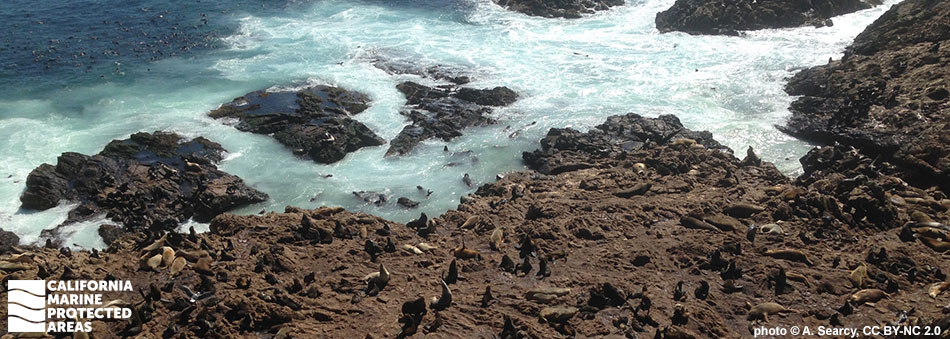
The North Farallon Islands Special Closure extends 1,000 feet seaward from North Farallon Island and 300 feet from the other three rocky islands, including the Island of St. James, in wide bands that surround each of the respective islands. The special closure is enforced year-round and restricts boating activity, protecting important Steller sea lion haul-out sites. Minimizing human activity also protects roughly 72,000 seabirds, including the common murre, western gull, Cassin’s auklet, and pigeon guillemot, that nest on the sheer cliffs.

These protected areas have long been recognized as biodiversity hotspots, with nutrient-rich waters that support breeding seabirds and schools of forage fish. Larger marine species including humpback whales and white sharks also come here to feed.

Regulations

North Farallon Islands SMR

It is unlawful to injure, damage, take, or possess any living, geological, or cultural marine resource.

California Code of Regulations Title 14, Section 632(b)(51)(opens in new tab)

North Farallon Islands Special Closure

Boating, access, and other specific activities are restricted. No person except employees of the California Department of Fish and Wildlife, United States Fish and Wildlife Service, National Oceanic and Atmospheric Administration, or United States Coast Guard during performance of their official duties, or unless permission is granted by the California Department of Fish and Wildlife, shall enter the area.

Additional restrictions related to boating speed limits, anchoring, commercial diving operation exhaust procedures, and transit exist. See California Code of Regulations Title 14, Section 632(b)(52) for details.

California Code of Regulations Title 14, Section 632(b)(52)(opens in new tab)

Quick Facts

North Farallon Islands SMR

MPA size: 18.07 square miles

Shoreline span: 8.3 miles

Depth range: 0 to 275 feet

Habitat composition*:

  • Rock: 1.03 square miles
  • Sand/mud: 16.06 square miles

North Farallon Islands Special Closure

Special Closure size: 0.21 square miles

Depth: 0 to 150 feet

Habitat composition*:

  • Rock: 0.24 square miles
  • Sand/mud: 0.07 square miles

*Habitat calculations are based on 3-dimensional area and may exceed the total MPA area listed above.

Photo Gallery

29 SEP
2022

Steller sea lions in North Farallon Islands Special Closure

0

photo © O. Johnson, CC BY-NC 2.0

Showing 0 Comment

Video Gallery

California's MPA Network

About North Farallon Islands State Marine Reserve/Special Closure

Natural History

a few feet over gray ocean waves, a black footed albatross glides, brown feathers with white edges line the outer limits of the wings, dark feather around the eyes are contrasted by bright white feather surrounding the large beak
Black-footed albatross at North Farallon Islands SMR. photo © C. Sulots, CC BY 2.0

The Farallon Islands marine environment consists of shallow rocky and sandy seafloor around the islands, surrounded by relatively deep, open ocean. The islands are situated within the California Current, which brings cold water south along the coast, and an upwelling zone that brings cold, nutrient-rich water from the depths to the surface during spring. This upwelled water supports the rapid growth and prolific reproduction of plankton, the base of the marine food web, and also makes the Farallon Islands a highly productive area for seaweeds, invertebrates, fishes, marine mammals, and birds.

Many species of fish are abundant here, including vermilion rockfish, copper rockfish, bocaccio, starry rockfish, lingcod, striped bass, salmon, and halibut. Marine mammals like northern elephant seals, California sea lions, and harbor porpoises hunt for fish, attracting a healthy population of white sharks. The Farallon Islands attract one of the largest congregations of white sharks in the world.

The Farallones are also home to the largest colony of nesting seabirds in the contiguous United States. There are 13 species of seabirds regularly nesting on these islands, and the North Farallon Islands Special Closure protects roughly 70,000 birds. Species of seabirds that roost on the rocky shores of the North Farallon Islands SMR include the western gull, common murre, pigeon guillemot, Brandt’s cormorant, Cassin’s auklet, and pelagic cormorant. Ashy storm-petrels are abundant here, with roughly half the global population of petrels supported by the Farallon Islands. From seabirds to marine mammals, these islands provide significant habitat and feeding opportunities for more than 25 threatened or endangered species.

Cultural History

light brown cliffsides meet the waterline, the water looks as if its boiling, a few dozen fins and heads of northern fur seals are along the shoreline, a few dozen more sit sunning on the shoreline
Northern fur seals in North Farallon Islands Special Closure. photo © C. Schwarz, CC BY 2.0

For centuries, Native American Tribes in California have relied on marine and coastal resources. Many Native American Tribes in California continue to regularly harvest marine resources within their ancestral territories and maintain relationships with the coast for ongoing customary uses. The islands, easily seen from the mainland on a clear day, were known as the “Islands of the Dead” by the Native Americans, who believed that spirits dwelt there. It is thought that Native Americans never traveled to the islands. The first documented landfall on the islands was on July 24th, 1579 by the Sir Francis Drake Expedition, which stopped to hunt seals and gather bird eggs.

Starting in the late 1700s, European, Russian, and New England fur traders arrived to hunt the abundant seal populations. The trade grew quickly, and seal populations declined dramatically. The expansion of the city of San Francisco in the mid-1800s also led to the commercial collection of seabird eggs. At the height of the trade, it is estimated 500,000 eggs were collected each month. This stopped abruptly in 1863 when two men were murdered on the islands in what is known as the “Egg War.”

Conservation of the Farallon Islands began in 1909 when Theodore Roosevelt created the Farallon Reservation. In 1969, North Farallon Island came under federal protection as this chain of dramatic rocky islands became the Farallon National Wildlife Refuge. Currently, the islands have multiple levels of protection with varied regulations, through the Greater Farallones National Marine Sanctuary, the Farallon Islands MPAs, and special closures. A handful of researchers live on the islands, but these islands remain strictly off-limits to visitors.

Recreation

a whale tail extending above ocean surface
Humpback whale in North Farallon Islands SMR. photo © K. Balcomb/NOAA

To protect the abundance of wildlife that lives on and around the Farallones, the Farallon Islands are not open to the public. The only people that have access to this region are a small group of wildlife biologists and resource managers, including scientists from Point Blue Conservation Science. However, the public can still explore this special place through both boating trips and virtual media. Whale watching trips are offered out of San Francisco that allow visitors the chance to see some of the 36 different species of marine mammals that live in these waters, from Steller sea lions and northern fur seals to gray, fin, blue, and humpback whales.

The California Academy of Sciences has set up a webcam that allows people to virtually witness the spectacle of feeding and nesting seabirds on the islands, and admire the remote scenic views of the Pacific Ocean. Though boating and other human activity is prohibited year-round in the waters adjacent to the four northern islands, just outside of the SMR's protected waters fishermen can enjoy a day on the water trolling for salmon or crabbing for Dungeness crab.

Coordinates

North Farallon Islands SMR

This area is bounded by straight lines connecting the following points in the order listed except where noted:

37° 45.700' N. lat. 122° 59.085' W. long.; thence northwestward along the three nautical mile offshore boundary to
37° 49.344' N. lat. 123° 07.000' W. long.;
37° 45.700' N. lat. 123° 07.000' W. long.; and
37° 45.700' N. lat. 122° 59.085' W. long.

California Code of Regulations Title 14, Section 632(b)(51)

North Farallon Islands Special Closure

A special closure is established at the islets comprising the North Farallon Islands. See California Code of Regulations Title 14, Section 632(b)(52) for details (link below).

California Code of Regulations Title 14, Section 632(b)(52)

Downloads for North Farallon Islands State Marine Reserve

Map

Map of North Farallon Islands State Marine Reserve - click to enlarge in new tab

Facts, Map & Regulations

MPA fact sheet - click to enlarge in new tab

Downloads for North Farallon Islands Special Closure

Map

Map of North Farallon Islands Special Closure - click to enlarge in new tab

Facts, Map & Regulations

MPA fact sheet - click to enlarge in new tab