False Klamath Rock Special Closure

A view of False Klamath Rock

Overview

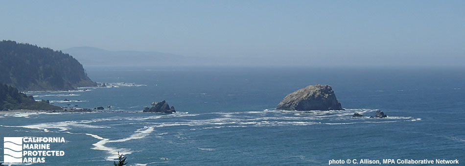
Located in rural Del Norte County between Klamath and Crescent City, False Klamath Cove is a special place with deep Native American ties and is home to a myriad of marine life. Tidepoolers, anglers, and tourists visiting the beach can witness a frenzied spectacle of birds on the impressive False Klamath Rock, located just offshore. A well-known rookery for nearly 45,000 birds, False Klamath Rock Special Closure protects at least eight different bird species. Species of special concern like tufted puffin and pigeon guillemot, double-crested cormorants, black oystercatchers, and common murres use the secluded sea stack for roosting and nesting.

False Klamath Rock is a special closure that protects a 300-foot buffer zone surrounding the rock from March 1 to August 31 every year. Restrictions on boating and human access help protect the thousands of birds that nest on this prominent sea stack. Boulder fields dot the adjacent sandy beach only a few yards away from Highway 101.

Regulations

March 1 to August 31 only:

Boating and access are restricted. Except as permitted by federal law or emergency caused by hazardous weather, no vessel shall be operated or anchored from the mean high tide line to a distance of 300 ft. seaward of the mean lower low tide line of any shoreline of False Klamath Rock.

No person except employees of the California Department of Fish and Wildlife, United States Fish and Wildlife Service, National Oceanic and Atmospheric Administration, or United States Coast Guard during performance of their official duties, or unless permission is granted by the California Department of Fish and Wildlife, shall enter the area.

California Code of Regulations Title 14, Section 632(b)(5)(opens in new tab)

Quick Facts

Special Closure size: 0.03 square miles

Depth range: 0 to 46 feet

Habitat composition*:

  • Rock: 0.07 square miles
  • Sand/mud: Less than 0.01 square miles

*Habitat calculations are based on 3-dimensional area and may exceed the total MPA area listed above.

Photo Gallery

2 OCT
2023

A view of False Klamath Rock from high above the mainland shore

0

photo © Calla Allison, MPA Collaborative Network

Showing 0 Comment

Video Gallery

California's MPA Network

About False Klamath Rock Special Closure

Natural History

hundreds of birds on a large rock
Common murres on False Klamath Rock. photo © Amelia Ryan, CC BY-NC 2.0

False Klamath Rock is the eroded evidence of colliding tectonic plates. For millions of years, the Gorda Plate that lies at the bottom of the Pacific Ocean has been sliding beneath the North American Plate. Some of the rocks, such as False Klamath Rock, rise from the ancient seafloor as sea stacks. False Klamath Rock consists of a combination of submarine volcanic rocks that have been eroded and shaped over time by constant wind and wave action.

The rocky shores of False Klamath Rock have long been recognized as an important place for thousands of birds, including Brandt’s cormorants and tufted puffins. Many species of fish inhabit the cold waters surrounding the rocky pinnacle, including smoothhead sculpin, fluffy sculpin, and northern clingfish. At high tide, the beach in False Klamath Cove almost entirely disappears as the ocean inundates this small strip of sandy and rocky shoreline. The back of the beach is protected by a barrier of large driftwood logs, and at low tide, elephant seals may bask on the sandy beach.

Cultural History

view of ocean with rock formation in the fog
A view of False Klamath Rock in the fog. photo © Justin Dolske, CC BY-SA 2.0

For centuries, Native American Tribes in California have relied on marine and coastal resources. Many Native American Tribes in California continue to regularly harvest marine resources within their ancestral territories and maintain relationships with the coast for ongoing customary uses. As part of the Yurok ancestral territory, False Klamath Cove lies on a stretch of coast with great cultural significance to indigenous people. The Yurok have been the primary environmental stewards of this coastal ecosystem for thousands of years, harvesting marine resources such as kelp, seaweed and mussels.

In 1828, Jedidiah Smith, an explorer from New York, landed an expedition here that marked the beginning of an influx of white settlers. However, the Yurok have remained a strong presence, and continue to be environmental stewards of False Klamath Cove. The Yurok tribe recently started an independent project to gather statistical information for marine management. In July 2017, a group called the Eagle Eyes of False Klamath Cove began observing and recording data for a behavioral study of human activities - from the number of people and type of activity occurring, to method of entrance to the beach, and type of recreational vehicles present. By identifying patterns of human behavior and use of the beach, the group helps to inform management strategies and implement interventions that may reduce disturbances to marine life.

Recreation

view of rock formation in the ocean between trees on shore
A view of False Klamath Rock from the trees on shore. photo © Calla Allison, MPA Collaborative Network

Wilson Creek Beach, the small stretch of sandy and rocky shoreline in False Klamath Cove, is a popular place for tidepooling, birdwatching, and picnicking. False Klamath Rock is easily seen from the beach and many people come to watch thousands of birds on the sea stack. Kayakers can launch from the beach, but must remain at least 300 feet away from the False Klamath Rock Special Closure from March 1 to August 31.

Curious beachgoers can peer into the shallow tidepools at the north and south end of the False Klamath Cove and see small crabs, acorn barnacles, California mussels, and ochre sea stars that grip tightly to the rocks in this exposed marine environment. People seeking to enjoy the spectacular views and watch the native wildlife from land can embark on the Yurok Loop trail, located at the south end of the cove. This easy route winds through spruce and Douglas fir trees and offers stunning coastal outlooks, including a breathtaking view of False Klamath Rock.

Klamath River, located just south of the cove, offers some of the best fishing during the fall months for both salmon and steelhead trout.

Coordinates

A special closure is designated from the mean high tide line to a distance of 300 feet seaward of the mean lower low tide line of any shoreline of False Klamath Rock, located in the vicinity of 41° 35.633 ′ N. lat. 124° 06.699 ′ W. long. during the period of March 1 to August 31.

California Code of Regulations Title 14, Section 632(b)(5)

Downloads for False Klamath Rock Special Closure

Map

Map of False Klamath Rock Special Closure - click to enlarge in new tab

Facts, Map & Regulations

MPA fact sheet - click to enlarge in new tab