Estero de San Antonio State Marine Recreational Management Area

a bending estuary feeds in the ocean, flanked by a rolling tan and green hillside, to ocean roars with foam and large jagged rocks

Overview

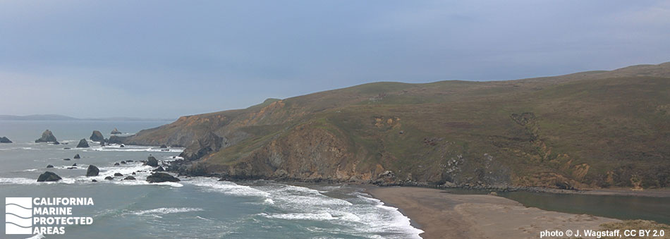
Located between Dillon Beach and Bodega Bay, just south of the Marin/Sonoma County line, lies Estero de San Antonio State Marine Recreational Management Area (SMRMA). Estero, Spanish for estuary, describes this low-lying sand flat. The SMRMA begins where the mouth of the larger Estero de San Antonio meets the Pacific Ocean, and runs approximately one mile into this estuarine environment, protecting less than a tenth of a square mile of habitat. Tidewater goby, ghost shrimp, mud shrimp, and starry flounder, as well as significant sea and shorebird aggregations depend upon this area for food and nursery grounds.

A sandbar often forms at the mouth of the estuary during the summer and fall, damming it until winter rains arrive. This creates a safe refuge for nesting shorebirds. While the remote beach is only accessible by boat or kayak, this area offers secluded and remote opportunities for wildlife and nature viewing.

Regulations

It is unlawful to injure, damage, take, or possess any living, geological, or cultural marine resource, EXCEPT:
Take of waterfowl in accordance with general waterfowl regulations is allowed.

California Code of Regulations Title 14, Section 632(b)(42)(opens in new tab)

Quick Facts

SMRMA size: 0.07 square miles

Shoreline span: 1.0 miles

Depth range: 0 to 10 feet

Habitat composition*:

  • Estuary: 0.07 square miles
  • Eelgrass: Less than 0.01 square miles

*Habitat calculations are based on 3-dimensional area and may exceed the total MPA area listed above.

Photo Gallery

7 SEP
2022

Looking east from Middle Road Bridge, just outside of Estero de San Antonio SMRMA

0

photo © G. Stephen, CC BY-NC 2.0

Showing 0 Comment

Video Gallery

California's MPA Network

About Estero de San Antonio State Marine Recreational Management Area

Natural History

shallow clear water casts lines of illumination on fine sand, a large california sea hare  sits in the water, dark purple on the sides, light green coloration on the top, small black flecks speckle the body
A California sea hare in Estero de San Antonio SMRMA. photo © S. Cordell, CC BY-NC 2.0

Estero de San Antonio is located on top of two main geological features: the Franciscan melange formation of crushed shale, sandstone, chert, greenstone and schist, and the Merced formation of young, fine-grained marine sandstone. These layers of rocks and sediment often contain fossils, and scientists believe sea level rise has already occurred in the low-lying area.

Estero de San Antonio is known for the sandbar that forms at its mouth in summer or early fall, creating a natural dam. Winter rains increase freshwater input and break the barrier to the ocean. This dam feature creates a safe nursery habitat for the endangered tidewater goby that breeds in shallow waters. Without the calm area provided by the sandbar, the fish would be required to lay their eggs in the rougher ocean waters where eggs have less protection while developing.

There are many species of fish within Estero de San Antonio including Pacific herring, staghorn sculpin, starry flounder and surfperch. By protecting a portion of this estuary, many larval and juvenile fish and invertebrates can grow until they are strong enough to survive on their own within Bodega Bay and the Pacific Ocean.

Cultural History

a caspian tern cuts through grey sky, an angular bird, with a bright fiery orange beak, white feathers and a black patch on the edge of its wingtips and head
Caspian tern at Estero de San Antonio SMRMA. photo © M. Vonshak, CC BY-NC 2.0

For centuries, Native American Tribes in California have relied on marine and coastal resources. Many Native American Tribes in California continue to regularly harvest marine resources within their ancestral territories and maintain relationships with the coast for ongoing customary uses. The Coast Miwok Native Americans lived along beaches at the mouth of Estero de San Antonio, hunting and gathering in small bands. Their traditional diet consisted of fish, invertebrates, and seaweeds.

The first recorded European exploration was by the Sir Francis Drake expedition in 1579, when they landed in what is now Marin County. There is speculation that Bodega Bay, immediately north of Estero de San Antonio, may have been Sir Francis Drake’s Nova Albion landing location on the California coast, though the actual landing site has never been confirmed. Today, this area provides unique research opportunities for students at the University of California Davis Bodega Marine Lab, located a couple miles north of the estuary, just past Bodega Head. Students and researchers study the surrounding areas including mudflats, sand dunes, and offshore waters.

Recreation

blue waters reflect the tan vegetation along some shoreline, a single long tailed duck swims, it has brown and white feathers, with a pure white neck, and a brown patch on its cheek
Long-tailed duck in Estero de San Antonio SMRMA. photo © M. Vonshak, CC BY-NC 2.0

Access to Estero de San Antonio is difficult, with the only consistent option being by kayak. Visitors can either launch from Dillon Beach to the south of the estuary, which is the shortest distance to the SMRMA, or rent a kayak from Bodega Bay to the north and paddle across. Alternatively, visitors can also try to walk to the estuary along the rocky coastline, but this can be difficult and needs to be timed correctly with the tides since the shortest distance from Dillon Beach is more than a mile away.

In Estero de San Antonio SMRMA, hunting of waterfowl is allowed unless otherwise restricted due to seasonal hunting regulations.


Boundary

This area includes the waters below the mean high tide line within Estero de San Antonio westward of longitude:
122° 57.400' W.

California Code of Regulations Title 14, Section 632(b)(42)

Downloads for Estero de San Antonio State Marine Recreational Management Area

Map

Map of Estero de San Antonio State Marine Recreational Management Area - click to enlarge in new tab

Facts, Map & Regulations

MPA fact sheet - click to enlarge in new tab