Dana Point State Marine Conservation Area

waves wash up on a beach, houses on bluffs in the background

Overview

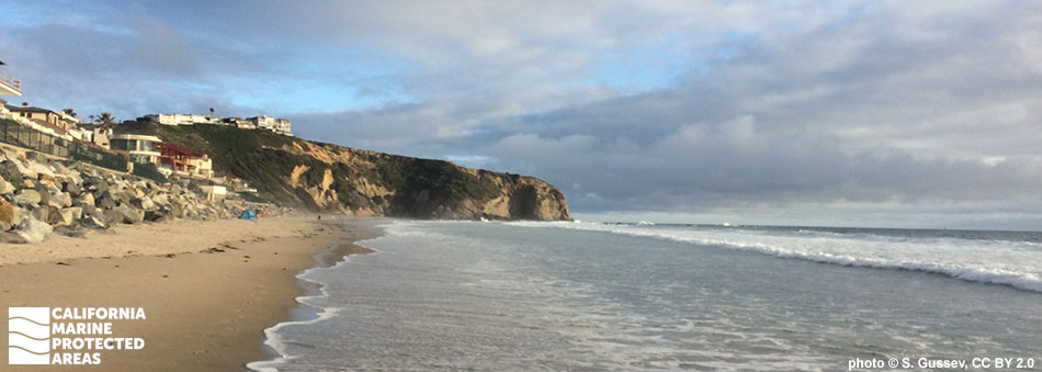
Dana Point State Marine Conservation Area (SMCA) is located about 20 miles south of Huntington Beach along Highway 1, nestled between South Laguna and Dana Point in Orange County. Its northern border abuts Laguna Beach SMCA (No-Take). Dana Point SMCA covers nearly four square miles of marine habitat from shore to depths of around 150 feet. Beachgoers, whale watchers, anglers, surfers and tidepoolers enjoy this spot regularly.

The coves, sandy beaches, rocky reefs, surfgrass beds, and kelp forests provide refuge for thriving California spiny lobster populations, many species of fish and birds, and rich tidepool communities. Scuba and free divers who venture beyond the waves can explore the giant kelp forests and may encounter California halibut, bright garibaldi or leopard sharks. Dolphins and sea lions are commonly seen from shore, and onshore tidepools expose vibrant marine life like scurrying crabs and the swaying tentacles of moonglow anemones.

Regulations

It is unlawful to injure, damage, take, or possess any living, geological, or cultural marine resource, EXCEPT:

Recreational take of finfish by hook-and-line or spearfishing, and lobster and urchin is allowed. Commercial take of lobster by trap, sea urchin, and coastal pelagic species (northern anchovy, Pacific sardine, Pacific mackerel, jack mackerel, and market squid) by round-haul net, brail gear, and light boat is allowed. Not more than five percent by weight of any commercial coastal pelagic species catch landed or possessed shall be other incidentally taken species. Take of living marine resources from tidepools is prohibited. 

California Code of Regulations Title 14, Section 632(b)(136)(opens in new tab)

Quick Facts

MPA size: 3.47 square miles

Shoreline span: 4.0 miles

Depth range: 0 to 152 feet

Habitat composition*:

  • Rock: 1.60 square miles
  • Sand/mud: 2.82 square miles

*Habitat calculations are based on 3-dimensional area and may exceed the total MPA area listed above.

Photo Gallery

25 AUG
2022

Marbled godwit in Dana Point SMCA

0

photo © B. Spencer, CC BY-NC 2.0

Showing 0 Comment

Video Gallery

Southern California Marine Protected Area Highlights

California's MPA Network

About Dana Point State Marine Conservation Area

Natural History

rocky beach below houses on bluff
Looking south at Salt Creek Beach in Dana Point SMCA. photo © S. Gussev, CC BY-NC 2.0

Waves, rain, tectonic faults, and coastal uplift have worked over millions of years to shape the coastline visible today. Within Dana Point SMCA, one can see exposed outcroppings of shale rock along the shoreline, sandstone bluffs towering over the beach, and 120,000-year-old marine terrace formations in the surrounding hills. Each year, more than 200,000 cubic meters of sand are moved by waves and longshore currents, causing an ever-changing and dramatic beach landscape. Perhaps the most striking natural feature in the SMCA is Three Arch Bay, where three dramatic arches are carved out of the cliffside.

A bit further south, Salt Creek Beach offers an expansive sandy beach with scattered rocky tidepools. Orange County's largest kelp forest is located off of Salt Creek Beach, within Dana Point SMCA. The dense kelp forest creates prime habitat for creatures such as giant sea bass, eels, copper rockfish, California spiny lobster, leopard sharks, and garibaldi. As much as 90 percent of the area's kelp forests have disappeared since the 1980s. However, restoration efforts beginning in 2002 have helped the kelp recover and reach historical densities.

A large expanse of sandy beach that extends beyond the waves and turns into sandy seafloor makes prime habitat for sand crabs and a variety of flatfish like halibut and sole. During low tide, the exposed tidepools come to life with limpets, snails, colorful sea stars, and the occasional octopus peeking out for curious tidepoolers. Seabirds, such as double-crested cormorants, find abundant food in Dana Point SMCA, while dolphins, seals, and sea lions are commonly spotted just beyond the waves.

Cultural History

sea lions on rocks
California sea lions and cormorants at Dana Point SMCA. photo © sfitzgerald86, CC BY-NC 2.0

For centuries, Native American Tribes in California have relied on marine and coastal resources. Many Native American Tribes in California continue to regularly harvest marine resources within their ancestral territories and maintain relationships with the coast for ongoing customary uses. The Dana Point area is within the traditional territory of the Tongva and Acjachemen peoples. They were skilled in hunting and fishing, and extremely knowledgeable in using the abundant and productive marine resources for food, tools, and art. These Tribes developed several specialized crafts and tools, including nets, fishhooks, and tule canoes. The canoes enabled travel offshore and access to deeper water marine resources within the kelp beds.

European expeditions in the area first occurred in 1542, although large-scale settlement did not begin until the mid-1700s during the era of the San Gabriel and San Juan Capistrano missions. Lands near Dana Point were primarily used as cattle and sheep ranchlands, as well as agricultural farms for decades, continuing into the 1970s. Capistrano Bay, now known as Dana Point, was a popular port for ships involved in the hide trade. Hippolyte de Bouchard, a French Argentine sailor who was known in the early 1800s as "California's only pirate" regularly anchored at Capistrano Bay and is rumored to have buried loot along the coastline north of Dana Point.

In the 1960s, construction began to transform Capistrano Bay into modern-day Dana Point Harbor. The harbor was dedicated in 1971 and provides slips and moorings for over 2,500 boats. Dana Point has a long and notable surfing history. The world's first retail surf shop opened in Dana Point in 1954 and various surf publications such as Surfer Magazine were formed and headquartered here. The southern end of Dana Point SMCA was known as "Killer Dana", a heavy, right-breaking wave that wrapped around the point and was a popular surf spot among locals. However, "Killer Dana" disappeared with the construction of the Dana Point Harbor breakwater.

Recreation

sea star next to a worn penny
Bat star in Dana Point SMCA. photo © P. Joe, CC BY-NC 2.0

Dana Point SMCA can be accessed from Highway 1 and offers an abundance of recreational activities, including kayaking, whale watching, diving, and fishing. On shore, there are ample tidepooling opportunities and gray whales can be seen during their annual migrations from December through April. 

For ocean lovers, there are multiple surf breaks, swimming spots, and dive sites. Snorkelers, scuba, and free divers can explore multiple kelp forests and rocky reefs including those at Monarch Point and Thousand Steps. Salt Creek Beach Park is a prime spot for sunset picnics. Surfing and tidepooling are popular at Salt Creek as well as Strand Beach to the south. 

On the cliffs at the south end of the SMCA, Dana Point Nature Interpretive Center offers informative nature and history tours. Beautiful views of Dana Point SMCA can be enjoyed from the three mile trail system of Dana Point Headlands Conservation Area.

Coordinates

This area is bounded by the mean high tide line and straight lines connecting the following points in the order listed:

33° 30.050' N. lat. 117° 44.762' W. long.;
33° 30.050' N. lat. 117° 46.000' W. long.;
33° 30.000' N. lat. 117° 46.000' W. long.;
33° 27.300' N. lat. 117° 43.300' W. long.;
33° 27.478' N. lat. 117° 42.276' W. long.; and
33° 27.622' N. lat. 117° 42.425' W. long.

California Code of Regulations Title 14, Section 632(b)(136)

Downloads for Dana Point State Marine Conservation Area

Map

Map of Van Damme State Marine Conservation Area - click to enlarge in new tab

Facts, Map & Regulations

MPA fact sheet - click to enlarge in new tab