Carmel Bay State Marine Conservation Area

rocky shore with waves rolling in

Overview

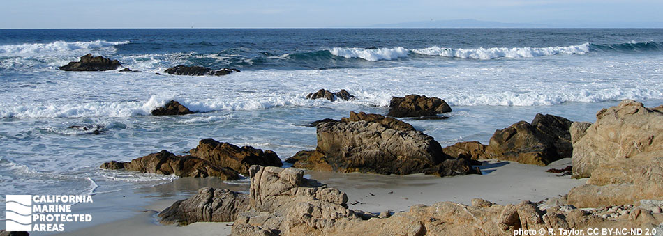
Carmel Bay State Marine Conservation Area (SMCA) is nestled between Pescadero Point and Point Lobos in Monterey County. This marine protected area (MPA) covers a little more than two square miles of nearshore waters inside Carmel Bay. The marine environment contains rocky reefs, sandy seafloor habitats, lush kelp forests, and large patches of surfgrass.

Carmel Bay SMCA is a hot spot for marine life, with nutrient-rich waters that support rockfish, leopard sharks, bottlenose dolphins, and sea lions. The waters extend from shallow tidepools to a submarine canyon that reaches depths of approximately 470 feet. Common fish species typically found in the kelp forests and rocky crevices include striped seaperch, cabezon, lingcod, and sculpin. Flatfish like starry flounder and sanddabs blend in with the sandy seafloor. Scattered throughout the bay, rocky outcroppings and shallow tidepools shelter strawberry and giant green anemones, sea lemon nudibranchs (sea slugs), decorator crabs, and a suite of other invertebrates.

Sea otters can be seen floating on the ocean surface in the kelp canopy. Gray whales and humpback whales occasionally pass through the bay during their annual migrations. Multiple white sand beaches run along the coastline adjacent to Carmel Bay SMCA. The recreational take of finfish and certain kelp harvesting is allowed in the SMCA, but take of other living marine resources is prohibited.

Regulations

It is unlawful to injure, damage, take, or possess any living, geological, or cultural marine resource, EXCEPT:
Recreational take of finfish is allowed. Commercial take of giant kelp and bull kelp by hand is allowed.

California Code of Regulations Title 14, Section 632(b)(80)(opens in new tab)

Quick Facts

MPA size: 2.20 square miles

Shoreline span: 2.7 miles

Depth range: 0 to 471 feet

Habitat composition*:

  • Rock: 1.91 square miles
  • Sand/mud: 1.32 square miles

*Habitat calculations are based on 3-dimensional area and may exceed the total MPA area listed above.

About Carmel Bay State Marine Conservation Area

Natural History

school of fish in kelp forest
Blue rockfish in a giant kelp forest in Carmel Bay SMCA. photo © Starbit, CC BY-NC 2.0

Encompassing the nearshore waters from Pescadero Point to Monastery Beach, Carmel Bay SMCA is characterized by sandy beaches, kelp forests, rocky reefs, sandy seafloor habitat, and deep crevices of a submarine canyon. The unique geology and complex bathymetry can be credited to millions of years of tectonic movement.

Near Point Lobos, the granite-like rocks and sandstone are remnants of an ancient slab that broke away from the continental crust millions of years ago. The mouth of the deep Carmel Submarine Canyon is located at the south end of Carmel Bay SMCA, and intersects the larger Monterey Submarine Canyon farther offshore. Currents circulate clockwise and upwelling from the deep submarine canyon brings nutrients to the surface, fueling immense productivity. These nutrient rich waters are home to an abundance of fish including cabezon, vermilion rockfish, blue rockfish, lingcod and surfperch.

A diversity of marine invertebrates including strawberry anemones, sea stars, barnacles, crabs, and sea urchins hide among the rocks. Marine mammals like sea lions and harbor seals can be found basking on the rocky shores while sea otters forage for food in the kelp forests.

Cultural History

snail with pointed, colorful shell
Jeweled top snail in Carmel Bay SMCA. photo © R.G. Agarwal, CC BY-NC 2.0

For centuries, Native American Tribes in California have relied on marine and coastal resources. Many Native American Tribes in California continue to regularly harvest marine resources within their ancestral territories and maintain relationships with the coast for ongoing customary uses. The Monterey Peninsula area has a long history of human residence, with the Ohlone peoples occupying the area for thousands of years. The Ohlone traditionally subsisted on abundant marine and terrestrial resources, collecting abalone, urchins, limpets, and seaweeds in rocky intertidal areas. Native people along the coast and Carmel River caught steelhead, salmon and shellfish, including abalone.

During the 18th century, many natives were displaced when Spanish fleets arrived. The Spanish built missions in the area, including the nearby San Carlos Borromeo de Carmelo Mission. When Mexico gained independence from Spain in the early 1800s, ranchos were established around Carmel, changing the culture and landscape as land was converted to pasture for cattle grazing. In the early 1850s, Chinese immigrants brought sophisticated fishing techniques, and Monterey emerged as a thriving fishing port. Commercial fisheries for abalone, rockfish, flatfish, sardines, and squid expanded.

The canneries brought further commercialization, with Monterey adopting the name "The Sardine Capital of the World". Between 1915 and 1950, roughly 235,000 tons of sardine were fished from the bay annually, until the fishery collapsed. Similar collapses of other fish stocks resulted in more stringent regulations. As fishing waned, conservation efforts gained momentum, leading to the creation of Monterey Bay National Marine Sanctuary. Protection efforts continued and Carmel Bay SMCA was established in 2007 as one of 29 MPAs adopted during the first phase of the Marine Life Protection Act Initiative along California's Central Coast.

Recreation

seabirds flying over shoreline
Sanderlings in Carmel Bay SMCA. photo © M. Roberts, CC BY-NC 2.0

At the north end of Carmel Bay SMCA, the pier at Stillwater Cove is a popular fishing spot, with common catches including black perch, striped seaperch, and the occasional rockfish or cabezon. Scuba divers can slip below the surface near Pescadero Rocks to explore the rocky reef and kelp forest. Near shore, along Carmel Beach, surfing and kayaking are popular activities. Kayakers can launch out of Stillwater Cove and are often spotted fishing or watching the marine life.

Carmel Pinnacles SMR, located in the waters farther offshore to the west, is another MPA and popular diving destination, home to impressive rocky spires covered with colorful hydrocorals. Visitors on shore can appreciate the beauty of Carmel Beach, a pristine white sand beach lined with Monterey cypress trees. Recreational take of finfish is allowed in Carmel Bay SMCA.

Coordinates

This area is bounded by the mean high tide line and straight lines connecting the following points in the order listed:

36° 33.663′ N. lat. 121° 57.117′ W. long.;
36° 31.700′ N. lat. 121° 56.300′ W. long.; and
36° 31.700′ N. lat. 121° 55.550′ W. long.

California Code of Regulations Title 14, Section 632(b)(80)

Carmel Bay State Marine Conservation Area

Map

Map of Carmel Bay State Marine Conservation Area - click to enlarge in new tab

Facts, Map & Regulations

MPA fact sheet - click to enlarge in new tab