 Ochre sea stars, giant green anemones, and sandcastle worms in the rocky intertidal area at Cambria SMCA and State Marine Park. photo © raffajomanfry, CC BY-NC 2.0
The Cambria coastline lies on what is known as the Cambria Slab, a 5,000-foot-thick piece of late-cretaceous sandstone. This massive geologic formation differs from the surrounding geology, and is undergoing uplift due to the movement of many local, active faults. The combination of uplift, soft sandstone, and intense wave action has created a complex and fragmented coastline here.
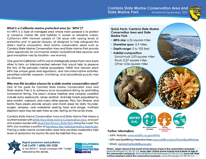
Rocky coves, seamounts, beaches, sandy seafloor, and kelp forests can all be found in Cambria SMCA and State Marine Park. Several nearby waterways, including Pico, San Simeon, and Santa Rosa creeks, feature estuary and marsh areas that drain into the MPAs.
Moonstone Beach is dotted with small pebbles of serpentine (the California state rock), agate, and moonstone. White Rock SMCA’s large surfgrass meadows, rocky reefs, and kelp forests provide refuge and nursery habitat for a variety of rockfish, cabezon, greenlings, and other rocky reef species.
Within both MPAs, the many different ecosystem types and the complex coastline result in an environment well suited for numerous marine species. Rockfish are abundant, notably blue rockfish, as well as cabezon and lingcod, which are frequently targeted by anglers. Kelp forests support southern sea otters, which feed on invertebrates such as crab, clams, abalone, and urchins. Northern elephant seals regularly visit on their way to breeding areas at Piedras Blancas Rookery to the north. Many whale species, primarily humpback whales and gray whales, can be seen offshore during their annual migrations.
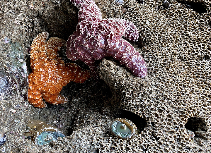
 Seabird feeding frenzy at Cambria SMCA and State Marine Park. photo © E. Bettenhausen, CC BY-NC 2.0
For centuries, Native American Tribes in California have relied on marine and coastal resources. Many continue to regularly harvest marine resources within their ancestral territories and maintain relationships with the coast for ongoing customary uses.
The Chumash people have a long, respectful, and deep connection with the central California coastal environment. They were the original inhabitants of the land adjacent to these MPAs for thousands of years. Living in coastal forests, the Chumash were skilled at crafting redwood canoes called tomols that allowed them to fish offshore. They also hunted sea lions and porpoises, and gathered abalone, clams, mussels, and barnacles. By the beginning of the 1800s, five missions had been built in Chumash territory and many native people were displaced. Today numerous Chumash people continue to reside in California, and two village sites sacred to the Chumash still exist in Cambria.
The first contact between the Chumash and Europeans occurred in 1542, when Juan Rodriguez Cabrillo arrived in the region. Early settlers were drawn to the productive central California land and coastal resources. Ranching, timber, fishing, and a brief era of seaweed harvest dominated local economic activities until the 1862 discovery of cinnabar, the ore from which mercury is refined. A short-lived mining boom ensued, which has since given way to the dairy industry.
The land around Cambria was originally part of a Mexican land grant, but investors bought the land in the 1860s. Cambria has been known by an array of names over the years, including Roseville, Santa Rosa, and Slabtown, but the community was officially named Cambria in 1870. Aside from shipping lumber, limited commercial fishing, and the construction of Hearst Castle, coastal resources around Cambria have remained relatively untouched.
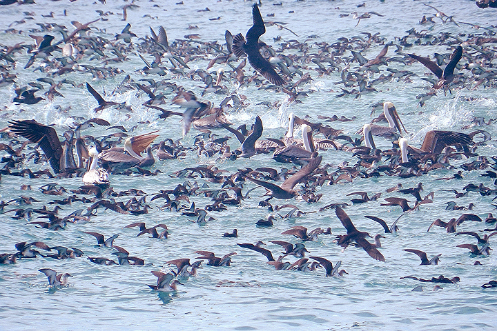
 Recreational angler at Moonstone Beach, Cambria SMCA and State Marine Park. photo © R. Schwemmer, NOAA
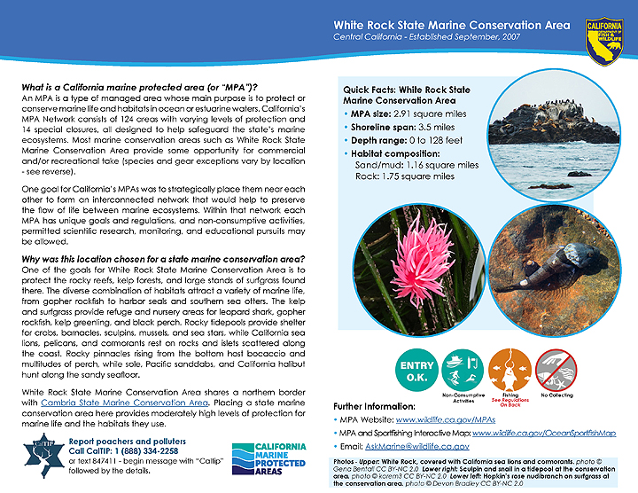
These two MPAs offer diverse recreational opportunities. The scattered pocket beaches and coastal trails are perfect for hiking, beachcombing, tidepooling, and general wildlife watching. From shore, visitors often see gray whales, humpback whales, southern sea otters, northern elephant seals, brown pelicans, and cormorants. Tidepool animals such as anemones, limpets, chitons, and sea stars are easily spotted at low tide. Offshore, divers can swim through kelp forests and see several species of rockfish and perch, as well as cabezon, California sheephead, abalone, gumboot chiton, rock scallops, and sheep crab.
Surfing is an option at some beaches, the most popular being Moonstone Beach in Cambria SMCA and State Marine Park, on the north end of the town of Cambria. Access to the northern end of Cambria SMCA and State Marine Park is relatively easy, as Highway 1 runs along the coast north of Cambria. Moonstone Beach, Leffingwell Landing Park, and Hearst San Simeon State Park offer coastal access, restrooms, and information about local natural resources. Small boats and kayaks can be launched at the Leffingwell Landing boat ramp, and camping is available at Hearst San Simeon State Park. The town of Cambria offers lodging, food, and amenities.
Recreational take of marine resources is not allowed within White Rock SMCA; however, recreational fishing is allowed within Cambria SMCA and State Marine Park in accordance with current recreational fishing regulations.
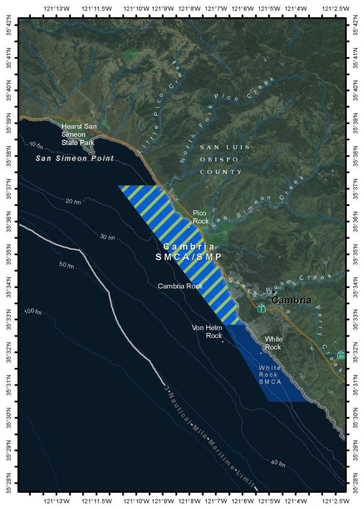
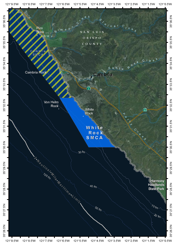
Cambria SMCA and State Marine Park
(Please note that Cambria SMCA and Cambria State Marine Park share the same boundaries).
This area is bounded by the mean high tide line and straight lines connecting the following points in the order listed:
35° 37.100′ N. lat. 121° 09.225′ W. long.;
35° 37.100′ N. lat. 121° 10.700′ W. long.;
35° 32.850′ N. lat. 121° 06.700′ W. long.; and
35° 32.850′ N. lat. 121° 05.855′ W. long.
California Code of Regulations Title 14, Section 632(b)(89)
White Rock SMCA
This area is bounded by the mean high tide line and straight lines connecting the following points in the order listed:
35° 32.850′ N. lat. 121° 05.855′ W. long.;
35° 32.850′ N. lat. 121° 06.700′ W. long.;
35° 30.500′ N. lat. 121° 05.000′ W. long.; and
35° 30.500′ N. lat. 121° 03.423′ W. long.
California Code of Regulations Title 14, Section 632(b)(90)
Cambria State Marine Conservation Area and State Marine Park
Map
Facts, Map & Regulations
White Rock State Marine Conservation Area
Map
Facts, Map & Regulations