Cabrillo State Marine Reserve

curved shoreline with tiered yellow stone beach

Overview

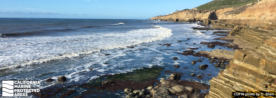
Cabrillo State Marine Reserve (SMR) is a marine protected area (MPA) that extends off Point Loma in San Diego County, about 10 miles north of the United States/Mexico border. Just under half a square mile, this MPA protects kelp forests, surfgrass beds, sandy seafloor, intertidal habitat, and nearshore rocky reefs, offering a spectacular gateway to explore the marine environment. A well-known location for tidepooling, thousands of visitors descend upon the shoreline of Cabrillo SMR each year to explore the rocky intertidal zone full of red and brown algae, barnacles, snails, chitons, whelks, limpets, and crabs.

An offshore kelp forest is home to kelp bass, California sheephead, abalone, and urchins. Onshore visitors can watch for gray whales during their annual migration or explore the adjacent Cabrillo National Monument, which offers visitors a glimpse into California history and culture, including the landing site of Juan Cabrillo’s journey to North America.

Regulations

It is unlawful to injure, damage, take, or possess any living, geological, or cultural marine resource.

California Code of Regulations Title 14, Section 632(b)(146)(opens in new tab)

Quick Facts

MPA size: 0.39 square miles

Shoreline span: 1 mile

Depth range: 0 to 30 feet

Habitat composition*:

  • Rock: 0.60 square miles
  • Sand/mud: 0.15 square miles

*Habitat calculations are based on 3-dimensional area and may exceed the total MPA area listed above.

Photo Gallery

29 MAR
2022

Surfgrass bed at Cabrillo State Marine Reserve

0

photo © sidesplotch, CC BY-NC 2.0
Comments are closed.

Video Gallery

Southern California Marine Protected Area Highlights


California's MPA Network

About Cabrillo State Marine Reserve

Natural History

hermit crabs in a tidepool
Hermit crabs in a tidepool at Cabrillo State Marine Reserve. CDFW photo by C. Shen

Cabrillo SMR is located on the southwestern tip of the peninsula, and bordered by sandstone cliffs that slope down into the intertidal zone. About 76 million years ago beneath the Pacific Ocean, sand, mud, and gravel were compressed to create a sedimentary geologic formation known as the Point Loma Formation. These rocks were then molded by uplift and erosion into the Point Loma Peninsula. Fossils from this period can still be found in the SMR’s tidepools.

From the intertidal zone to rocky reefs, the SMR protects several thriving natural communities. In nearshore tidepools, mussels, barnacles, brittle stars, and gobies navigate daily tidal fluctuations and hide among mats of coralline algae, seaweed, and seagrass. In deeper water, leopard sharks and barred sand bass cruise the sandy seafloor, while California sheephead hunt urchins, and California spiny lobsters and abalone hide in rocky crevices shaded by towering giant kelp. Beyond the edge of the kelp forest in deeper waters, gray whales pass by during their annual migration between Alaska and Baja Mexico.

The SMR protects habitat for more than 200 species of migrant and resident birds, including brown pelicans, black oystercatchers, cormorants, and terns; many species can be seen soaring in the sky, resting on the rocks, or foraging along the rocky shoreline for food.

Cultural History

lighthouse and adjacent building
Old Point Loma lighthouse. CDFW photo by C. Shen

For centuries, Native American Tribes in California have relied on marine and coastal resources. Many of these Tribes continue to regularly harvest marine resources within their ancestral territories and maintain relationships with the coast for ongoing customary uses. The Kumeyaay people have lived in what is now San Diego County for thousands of years. The Kumeyaay traditionally harvest the coast's animals and plants for both food and jewelry.

Point Loma experienced its first recorded European visitor in September 1542 when Juan Rodriguez Cabrillo landed. Originally named “La Punta de la Loma de San Diego”, which means Hill Point of San Diego, the official name was later changed to Point Loma. The first European colonizers, a combination of soldiers, explorers, and missionaries, arrived in 1769. In 1848, the Treaty of Guadalupe Hidalgo gave ownership of the land to the United States. The treaty split the homelands of the Kumeyaay, leaving part of their people on either side of the border between the United States and Mexico.

In 1851, a year after California gained statehood, Point Loma, at 422 feet above sea level, was selected as an ideal spot for a lighthouse. However, low lying fog and clouds obscured the light, and it was decommissioned in 1891. When the United States government recognized the military significance of the location, Fort Rosecrans was established on the point. This military reserve afforded vital coastal and harbor defense throughout World Wars I and II. In October 1913, the half-acre of ground surrounding the old lighthouse was proclaimed Cabrillo National Monument to commemorate Juan Rodriguez Cabrillo. Today, the old lighthouse remains open to visitors, and the new lighthouse, automated in 1973, continues to warn mariners about the rocky point.

Recreation

person examines shallow water among rocks near cliff
Tidepool docent at Cabrillo State Marine Reserve. CDFW photo by C. Shen

The shoreline along Cabrillo SMR is an accessible rocky intertidal area that offers ample opportunities for coastal exploration. The easiest access is through Cabrillo National Monument. During low tide, visitors can explore the diversity of life hiding in the tidepools. However, collecting any items, from rocks and shells to fish, algae, and any other marine resource, is not permitted within the SMR.

Cabrillo National Monument Visitor Center delivers interpretive information about the location's cultural and natural history, and offers striking views of the SMR and Baja’s Los Coronados Islands that lie offshore. Visitors can also get a glimpse of Ballast Point, thought to be the landing site of Cabrillo in 1542. There are walking paths within the National Monument, and Old Point Loma Lighthouse has a historically refurbished interior and remains open to the public as a museum. Sightseers have opportunities to view migrating gray whales from December to March, as well as more than 200 species of birds. This is considered one of the best birdwatching spots in San Diego.

Coordinates

This area is bounded by the mean high tide line and straight lines connecting the following points in the order listed:

32° 40.600′ N. lat. 117° 14.820′ W. long.;
32° 40.600′ N. lat. 117° 15.000′ W. long.;
32° 39.700′ N. lat. 117° 15.000′ W. long.;
32° 39.700′ N. lat. 117° 14.300′ W. long.; and
32° 40.000′ N. lat. 117° 14.300′ W. long.

California Code of Regulations Title 14, Section 632(b)(146)

Downloads for Cabrillo State Marine Reserve

Map

Map of Cabrillo State Marine Reserve - click to enlarge in new tab

Facts, Map & Regulations

MPA fact sheet - click to enlarge in new tab

Marine Region (Region 7)
Regional Manager: Dr. Craig Shuman
Main Office: 20 Lower Ragsdale Drive, Suite 100, Monterey, CA  93940
Email CDFW's Marine Region  |  (831) 649-2870
Office Locations  |  Marine Blog  |  Subscribe