Bodega Head State Marine Reserve/State Marine Conservation Area

small beach wedged between ridges descending into the sea

Overview

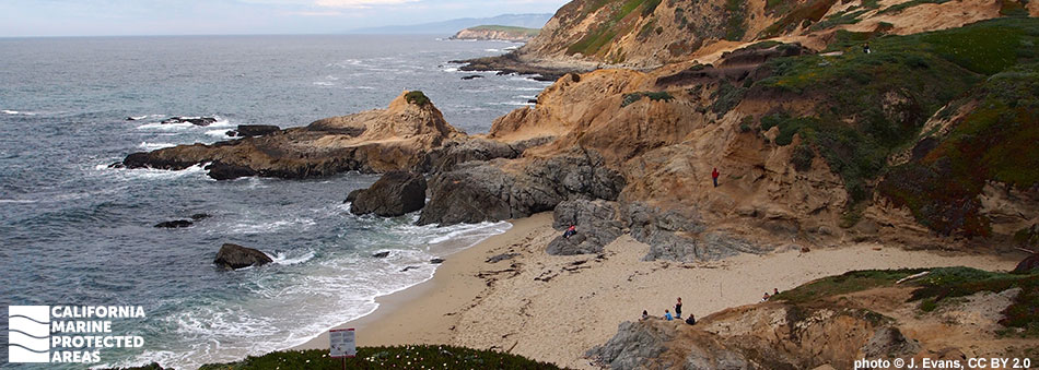
Bodega Head State Marine Reserve (SMR) sits along Sonoma County’s Bodega Head, a prominent headland 40 miles to the north of San Francisco. Bodega Head SMR lies north of and adjacent to Bodega Head State Marine Conservation Area (SMCA). Together the marine protected areas (MPAs) cover approximately 22 square miles, from shore to depths of over 260 feet. Bodega Head SMR spans about 2½ miles of shoreline and encompasses more than nine square miles of sandy beaches, rocky intertidal zones dotted with tidepools, surfgrass beds, soft sedimentary seafloor, and offshore rocky reefs.

While Bodega Head SMCA has few sandy beaches and rocky intertidal zones dotted with tidepools, it encompasses more than 12 square miles of sandy seafloor and offshore rocky reefs. One of the most expansive rocky reefs in northern California is almost entirely encompassed within these two MPAs. The rich diversity of habitats combined with offshore upwelling of nutrients provide resources for a wide range of marine life. Gray whales are frequently spotted offshore during their migration between Baja Mexico and Alaska. Seals and sea lions resting on the shore can be heard barking over the crash of the waves. Lingcod, rockfish, and greenlings live among the submerged rocks and kelp forest, and Dungeness crab scuttle across the same sandy seafloor that camouflages flatfish, such as halibut. No take of marine resources is allowed within the SMR, but the SMCA allows certain recreational and commercial take.

Regulations

Bodega Head SMR

It is unlawful to injure, damage, take, or possess any living, geological, or cultural marine resource. Additionally, within the Bodega Marine Life Refuge (a small nearshore area within Bodega Head SMR): No anchoring except as permitted by federal law, or during hazardous weather. The California Department of Fish and Wildlife and the Bodega Marine Life Refuge director may permit access, anchoring, and take for scientific or educational purposes.

California Code of Regulations Title 14, Section 632(b)(39)(opens in new tab)

Bodega Head SMCA

It is unlawful to injure, damage, take, or possess any living, geological, or cultural marine resource, EXCEPT:

Recreational take of Dungeness crab by trap, market squid by hand-held dip net, and pelagic finfish (northern anchovy, barracudas, billfishes, dorado (dolphinfish), Pacific herring, jack mackerel, Pacific mackerel, salmon, Pacific sardine, blue shark, salmon shark, shortfin mako shark, thresher shark, swordfish, tunas, Pacific bonito, and yellowtail) by trolling is allowed. Commercial take of Dungeness crab by trap, market squid by round-haul net, and pelagic finfish (no commercial take of marlin is allowed) by trolling or round-haul net is allowed. Not more than five percent by weight of any commercial pelagic finfish or market squid catch landed or possessed shall be other incidentally taken species.

California Code of Regulations Title 14, Section 632(b)(40)(opens in new tab)

Quick Facts

Bodega Head SMR

MPA size: 9.34 square miles

Shoreline span: 2.4 miles

Depth range: 0 to 266 feet

Habitat composition*:

  • Rock: 5.15 square miles
  • Sand/mud: 6.48 square miles

Bodega Head SMCA

MPA size: 12.31 square miles

Shoreline span: 0.2 miles

Depth range: 0 to 267 feet

Habitat composition*:

  • Rock: 5.80 square miles
  • Sand/mud: 7.98 square miles

*Habitat calculations are based on 3-dimensional area and may exceed the total MPA area listed above.

Photo Gallery

16 SEP
2022

Brown pelican at Bodega Head SMR

0

photo © F. Schulenburg, CC BY-SA 2.0

Showing 0 Comment

Video Gallery

California's MPA Network

About Bodega Head State Marine Reserve/State Marine Conservation Area

Natural History

hermit crab
Pacific hairy hermit crab in Bodega Head SMR. photo © A. Young, CC BY-NC 2.0

Bodega Head SMR and SMCA and the surrounding region are located along the highly active San Andreas Fault. The granite “Bodega Head” feature itself was sheared off the southern edge of the Sierra Nevada Mountains millions of years ago and transported northward by the Pacific Plate. The Bodega Head MPAs protect the beaches, rocky shoreline, sandy seafloor, and rocky reefs west of Bodega Head.

The Bodega Head promontory, or headland, also supports one of the most persistent and important upwelling plumes along California’s coast. During spring months, strong winds push surface waters offshore, causing deep, cold, nutrient-rich water to come to the surface near shore in a process called upwelling. This nutrient-rich water feeds plankton blooms, which attract krill and small fish, which in turn support the entire marine food web within the area.

Gray whales feast in the rich waters during their migrations, and seabirds such as cormorants, murres, guillemots, and auklets forage for fish. Beneath the surface, a modest kelp forest is home to many animals including rockfish, surfperch, greenlings, urchins, and abalone. Closer to shore, sand crabs submerge themselves in beach sand, while mussels and barnacles adhere to the hard rocks of the intertidal zone tidepools, filter-feeding on the plankton that washes over them with each incoming wave.

Cultural History

churning ocean water next to plant covered rocks
Sea palm in Bodega Head SMCA. photo © J. Gorneau, CC BY-NC 2.0

For centuries, Native American Tribes in California have relied on marine and coastal resources. Many Native American Tribes in California continue to regularly harvest marine resources within their ancestral territories and maintain relationships with the coast for ongoing customary uses. Currently part of the Graton Rancheria Tribe, Bodega Bay is the traditional home of the Bodega Miwok. The traditional Bodega Miwok diet consists of many species of fish, invertebrates, and seaweeds harvested from the shore and ocean.

Indigenous peoples were quickly overrun by foreign explorers when Spanish ships arrived in the early 1800s. Bodega Bay was named for Don Juan Francisco de la Bodega y Quadra, who arrived on one of the first Spanish ships of exploration. The region was subsequently explored and settled by Russians, Spaniards, Mexicans, and European-Americans. This exploration and settlement brought fur trapping, commercial fishing, cattle ranching, and missions to the area.

In the early 1960s, the Bodega Head area was selected as the site of a new Pacific Gas and Electric nuclear power plant. Plans for this power plant ultimately ended due to conservation efforts.

Bodega Head houses the University of California at Davis' Bodega Marine Laboratory. Established in 1960 to support field researchers studying the area, Bodega Marine Laboratory offers facilities for faculty, visiting scientists, local schools, and graduate and undergraduate students.

Recreation

narrow, grassy land mass extends into sea through fog
Horseshoe Cove Overlook near Bodega Head SMCA. photo © N. Doty, CC BY-NC 2.0

Visitors can enjoy the Bodega Head MPAs by land or by sea. Easily accessible from Highway 1, guests can park their cars and hike the Overlook Trail to the southernmost point of Bodega Head, which is within Sonoma Coast State Park. Parking and bathrooms are located at the Bodega Bay Trailhead, at the end of Westshore Road, and at Campbell Cove Beach. The Bodega Head Trail, a one- to two-mile loop on top of Bodega Head, is handicapped-accessible and is an ideal location for appreciating the beauty of the California coast and these MPAs.

From the Bodega Head promontory high over the Pacific Ocean, visitors can observe migrating whales, seabirds, seals, and sea lions. Whale-watching charter boats take people into the MPAs for an up-close experience. If you plan to go fishing, remember that the SMR prohibits all take but the SMCA allows for some types of commercial and recreational take of marine resources, including Dungeness crab; please check all regulations before embarking on a fishing trip. Visitors may also visit the University of California, Davis Bodega Marine Laboratory, which offers free docent-led tours of the facility including numerous marine aquarium displays showcasing the marine life found in the MPAs.

Coordinates

Bodega Head SMR

This area is bounded by the mean high tide line and straight lines connecting the following points in the order listed except where noted:

38° 20.100' N. lat. 123° 04.123' W. long.;
38° 20.100' N. lat. 123° 08.448' W. long.; thence southward along the three nautical mile offshore boundary to
38° 18.000' N. lat. 123° 08.140' W. long.; and
38° 18.000' N. lat. 123° 03.680' W. long.

California Code of Regulations Title 14, Section 632(b)(39)

Bodega Head SMCA

This area is bounded by the mean high tide line and straight lines connecting the following points in the order listed except where noted:

38° 18.000' N. lat. 123° 03.680' W. long.;
38° 18.000' N. lat. 123° 08.140' W. long.; thence southward along the three nautical mile offshore boundary to
38° 13.340' N. lat. 123° 03.510' W. long.; and
38° 17.930' N. lat. 123° 03.510' W. long.

California Code of Regulations Title 14, Section 632(b)(40)

Downloads for Bodega Head State Marine Reserve

Map

Map of Bodega Head State Marine Reserve - click to enlarge in new tab

Facts, Map & Regulations

MPA fact sheet - click to enlarge in new tab

Downloads for Bodega Head State Marine Conservation Area

Map

Map of Bodega Head State Marine Conservation Area - click to enlarge in new tab

Facts, Map & Regulations

MPA fact sheet - click to enlarge in new tab