Blue Cavern Onshore State Marine Conservation Area (No-Take) / Offshore State Marine Conservation Area

caverns in shoreline cliffs

Overview

Blue Cavern Onshore State Marine Conservation Area (SMCA) (No-Take), and the larger Blue Cavern Offshore SMCA are adjacent marine protected areas (MPAs) located on Santa Catalina Island’s west end, a little more than 20 miles from the southern California mainland.

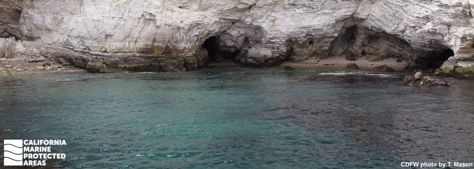
Blue Cavern Onshore SMCA (No-Take) protects around two and a half square miles of marine ecosystems to depths of nearly 900 feet. The SMCA has a wide range of underwater environments within its boundaries, including kelp-filled coves, surfgrass beds, pebble beaches, underwater caves, and rocky reefs. It also encompasses an area that was originally part of the Catalina Marine Science Center Marine Life Refuge, which protected Big Fisherman’s Cove for more than 30 years before it became part of Blue Cavern Onshore SMCA (No-Take) in 2012.

The University of Southern California’s Wrigley Marine Science Center is located onshore and adjacent to Big Fisherman’s Cove. Established in 1995, the research facility offers students and scientists easy access to a relatively secluded and undisturbed area that makes an excellent natural laboratory.

Protecting slightly less than eight square miles of marine ecosystems, Blue Cavern Offshore SMCA primarily protects sandy seafloor and offshore rocky reefs, including Isthmus Reef and Ship Rock, between depths of approximately 260 and 2,600 feet. This offshore MPA provides protection for species found in deep water such as rockfish and lingcod, while allowing limited fishing for pelagic fish such as yellowtail and Pacific bonito.

Regulations

Blue Cavern Onshore SMCA (No-Take)

It is unlawful to injure, damage, take, or possess any living, geological, or cultural marine resource. Also, no anchoring or mooring is permitted within the former Catalina Marine Science Center Marine Life Refuge.

California Code of Regulations Title 14, Section 632(b)(124)(opens in new tab)

Blue Cavern Offshore SMCA

It is unlawful to injure, damage, take, or possess any living, geological, or cultural marine resource, EXCEPT:
Recreational take of market squid by hand-held dip net, pelagic finfish (northern anchovy, barracudas, billfishes, dorado (dolphinfish), Pacific herring, jack mackerel, Pacific mackerel, salmon, Pacific sardine, blue shark, salmon shark, shortfin mako shark, thresher shark, swordfish, tunas, Pacific bonito, and yellowtail) by hook-and-line or by spearfishing, and white seabass by spearfishing is allowed. Commercial take of pelagic finfish (no commercial take of marlin is allowed) by hook-and-line, and swordfish by harpoon is allowed.

California Code of Regulations Title 14, Section 632(b)(125)(opens in new tab)

Quick Facts

Blue Cavern Onshore SMCA (No-Take)

MPA size: 2.61 square miles

Shoreline span: 2.2 miles

Depth range: 0 to 892 feet

Habitat composition*:

  • Rock: 0.15 square miles
  • Sand/mud: 2.54 square miles

Blue Cavern Offshore SMCA

MPA size: 7.70 square miles

Depth range: 267 to 2,616 feet

Habitat composition*:

  • Rock: Less than 0.01 square miles
  • Sand/mud: 7.69 square miles

*Habitat calculations are based on 3-dimensional area and may exceed the total MPA area listed above.

Photo Gallery

25 JUL
2022

Kelp forest at Blue Cavern Onshore SMCA (No-Take)

0

photo © M. Winscher

Showing 0 Comment

Video Gallery

Blue Cavern Onshore State Marine Conservation Area

Southern California Marine Protected Area Highlights

California's MPA Network

About Blue Cavern Onshore State Marine Conservation Area (No-Take) / Offshore State Marine Conservation Area

Natural History

fish swimming through kelp
Opaleye in giant kelp at Blue Cavern Onshore SMCA (No-Take). photo © seavivs, CC BY-NC 2.0

The exceptional abundance, diversity, and health of the ecological communities in the Blue Cavern MPAs is directly related to their long history of protection. Large California sheephead and kelp bass are common in the nearshore MPA. California spiny lobsters are found in abundance here, and rare species like the scythe butterflyfish, rainbow scorpionfish, and Guadalupe cardinalfish sometimes make an appearance. Gorgonians, a type of colorful soft coral, sway in the currents. This is one of the many locations at Santa Catalina Island where abalone, especially pink and green abalone, are commonly seen.

The Blue Cavern MPAs sit at the edge of a mountainous ridge that forms the backbone of Santa Catalina Island. Bird Rock, a notable outcrop, is found within Blue Cavern Onshore SMCA (No-Take). Diving around Bird Rock reveals a steep drop-off wall and shallow reefs with kelp forests and understory algae, occupied by a striking number of large fish and invertebrates such as octopus, rockfish, and sea cucumbers. Acorn barnacles, gooseneck barnacles, California mussels, golden rockweed, red algal turf, and ochre sea stars line the rocks in the intertidal zone of the nearshore MPA.

Blue Cavern Onshore SMCA (No-Take) shares a deep-water boundary with its neighbor, Blue Cavern Offshore SMCA, where the seafloor drops down to depths in excess of 2,600 feet. Market squid school and lay their egg cases along the deep sandy seafloor, while sea whips and sea pens stand upright in stark contrast to the relatively flat and seemingly barren stretches of sediment. Flatfish such as California halibut and C-O sole hide out in the open, perfectly camouflaged against the grains of sand.

Cultural History

view of ocean with large rock emerged in the distance
View of Blue Cavern MPAs and Bird Rock from Santa Catalina Island. photo by C. Allison, MPA Collaborative Network

Native American Tribes in California have relied on marine and coastal resources for centuries. Many Native American Tribes in California continue to regularly harvest marine resources within their ancestral territories and maintain relationships with the coast for ongoing customary uses. Originally inhabited by Native Americans known as the Tongva, Santa Catalina Island, also known as Pimugna or Pimu by these first peoples, provided abundant resources for permanent villages for thousands of years. Ancient tools hand-fashioned from stone, shell, and bone, and piles of abalone shells have been uncovered at ancient village sites.

Captain Juan Rodriguez Cabrillo, a Portuguese navigator in service to Spain, was likely the first European explorer to visit the island in 1542, anchoring two tiny caravel ships off the Bay of Avalon. In November 1602, Philip III of Spain sent an expedition under command of Sebastian Vizcaino to map the California coastline. He anchored in what is now the crescent shaped harbor of Avalon on Saint Catherine’s Day and renamed the small sunny island “Santa Catarina” or “Cathalina”.

In 1885, the island was sold for $200,000 to George R. Shatto, who sold land parcels to buyers from all over the country. In 1919, the island again changed hands and was sold for $3 million to the multi-millionaire chewing gum mogul and owner of the Chicago Cubs baseball team, William Wrigley Jr., who set out to make it a tourist destination.

The early 1900s was a golden age for Santa Catalina Island. Movie stars and famous figures flocked to the island to relax and hide from fans. Charlie Chaplin, Humphrey Bogart, Winston Churchill, and Errol Flynn frequented the island to fish for marlin and other game fish. In the 1970s, Wrigley deeded 88 percent of the island to the Catalina Island Conservancy, and today much of it remains undeveloped and wild. Santa Catalina Island’s rich history can be seen in many of the historic landmarks that dot the landscape.

Recreation

bright orange fish next to seaweed covered rock
Garibaldi. photo © zlevine, CC BY-NC 2.0

The area around the Blue Cavern MPAs is a great place to explore the quieter end of Catalina Island. With a portion of the Blue Cavern Onshore SMCA (No-Take) designated a no-take area for decades before the current MPAs’ implementation, the marine environment within Big Fisherman’s Cove makes for excellent diving, snorkeling, and kayaking, though anchoring is not allowed in the cove. Bird Rock is also a popular dive site, and there are many coves and caves to explore within the nearshore MPA boundaries.

The neighboring University of Southern California, Wrigley Marine Science Center offers opportunities for education programs including lectures on the area, laboratories, tours, and outdoor activities, which can be organized for K-12 students, undergraduate groups, and other interested groups.

No recreational or commercial take of marine resources is permitted within Blue Cavern Onshore SMCA (No-Take). Blue Cavern Offshore SMCA, however, allows recreational take of white seabass and pelagic finfish by spear, pelagic finfish by hook and line, as well as market squid by hand-held dip net. Visitors hiking around Santa Catalina Island can enjoy scenic vistas of the Blue Cavern MPAs. Outside the MPA boundaries, the adjacent town of Two Harbors offers recreational opportunities including hiking, snorkeling, scuba diving, ocean kayaking, mountain biking, seaside camping, disc golf, pleasure boating, and just relaxing on a sandy beach. Guest accommodations at Two Harbors include ocean view cottages, camping cabins, and multiple campgrounds, each offering a unique outdoor experience.

Coordinates

Blue Cavern Onshore SMCA (No-Take)

This area is bounded by the mean high tide line and straight lines connecting the following points in the order listed:

33o 25.960 ′ N. lat. 118o 27.000 ′ W. long.; and
33o 27.500 ′ N. lat. 118o 27.000 ′ W. long;
33o 27.500 ′ N. lat. 118o 29.300 ′ W. long.; and
33o 26.640 ′ N. lat. 118o 29.300 ′ W. long.

California Code of Regulations Title 14, Section 632(b)(124)

Coordinates for the No Anchor Zone Boundary within the SMCA, at the formerly designated Catalina Marine Science Center Marine Life Refuge, are as follows:

33o 26.650' N. lat. 118o 29.317' W. long.;
33o 26.833' N. lat. 118o 29.133' W. long.;
33o 26.958' N. lat. 118o 28.558' W. long.;
33o 26.917' N. lat. 118o 28.553' W. long., and
33o 26.892' N. lat. 118o 28.583' W. long.

Blue Cavern Offshore SMCA

This area is bounded by straight lines connecting the following points in the order listed except where noted:

33o 27.500 ′ N. lat. 118o 27.000 ′ W. long.;
33o 29.970 ′ N. lat. 118o 27.000 ′ W. long.; thence northwestward along the three nautical mile offshore boundary to
33o 30.810 ′ N. lat. 118o 29.300 ′ W. long.;
33o 27.500 ′ N. lat. 118o 29.300 ′ W. long.; and
33o 27.500 ′ N. lat. 118o 27.000 ′ W. long.

California Code of Regulations Title 14, Section 632(b)(125)

Downloads for Blue Cavern Onshore State Marine Conservation Area (No-Take)

Map

Map of Blue Cavern Offshore SMCA (No-Take) - click to enlarge in new tab

Facts, Map & Regulations

MPA fact sheet - click to enlarge in new tab

Downloads for Blue Cavern Offshore State Marine Conservation Area

Map

Map of Blue Cavern Offshore State Marine Conservation Area - click to enlarge in new tab

Facts, Map & Regulations

MPA fact sheet - click to enlarge in new tab