Begg Rock State Marine Reserve

birds on large rock rising above ocean surface

Overview

Begg Rock State Marine Reserve (SMR) sits 60 miles south of Ventura, far off the southern California mainland and more than eight miles off the northwest side of San Nicolas Island. This marine protected area (MPA) safeguards the waters around Begg Rock and encompasses nearly 38 square miles of the Pacific Ocean.

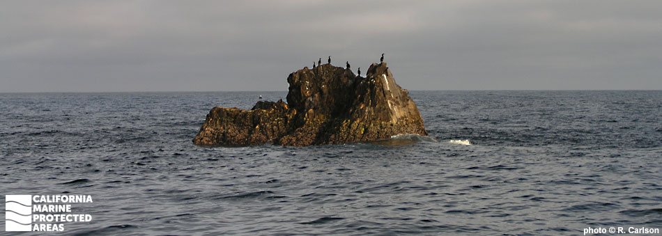
Begg Rock is an exposed offshore pinnacle surrounded by rocky reef habitat. It rises 300 feet from the ocean floor, its pinnacle reaching 15 feet above the ocean's surface. Although most of the deep seafloor within the SMR is sand and other soft sediments, over 13 square miles of rocky seafloor provides shelter for an amazing array of sea life within its crags, crevices and ridges. Exposed to strong open ocean currents, the massive pinnacle system is covered with filter feeders such as mussels, anemones, bryozoans, sponges, and scallops. 

This offshore SMR often experiences rough and windy conditions. Although not out of reach, visiting this MPA requires a seven- to eight-hour boat ride from Ventura.

Regulations

It is unlawful to injure, damage, take, or possess any living, geological, or cultural marine resource.

California Code of Regulations Title 14, Section 632(b)(115)(opens in new tab)

Quick Facts

MPA size: 37.96 square miles

Depth range: 0 to 374 feet

Habitat composition*:

  • Rock: 13.20 square miles
  • Sand/mud: 24.76 square miles

*Habitat calculations are based on 3-dimensional area and may exceed the total MPA area listed above.

Photo Gallery

11 JUL
2022

Purple hydrocoral at Begg Rock SMR

0

photo © C. Grossman, diver.net

Showing 0 Comment

Video Gallery

Southern California Marine Protected Area Highlights

California's MPA Network

About Begg Rock State Marine Reserve

Natural History

giant keyhole limpet, barnacles, anemones
Giant keyhole limpet, barnacles, sea urchins, and anemones at Begg Rock SMR. photo © C. Grossman, diver.net

San Nicolas Island is one of the smallest Channel Islands, at only eight miles long. It is also the farthest from the mainland of all the Channel Islands. Begg Rock is located 8.8 miles from the western point of San Nicolas Island.

Steeply rising 300 feet from the ocean floor to the surface, Begg Rock is part of a unique, offshore rock and pinnacle ecosystem. This MPA is bathed by cold water currents that push south from Alaska. Above the waterline, the rock is mostly barren, but below the surface the rock and reef are carpeted with invertebrate life. Mollusks, grey moon sponges, and a wide variety of brittle stars cover the rock surfaces. A tapestry of anemones sway with the current, including white-plumed and giant green anemones. Rock scallops abound, reaching large sizes. California hydrocoral of various colors add vibrancy, and the rare purple hydrocoral filter feeds on rich plankton from the swift currents.

On the northeast side of Begg Rock, a 55-feet-deep plateau features a tunnel that experienced divers can explore. Along the deeper ledges, starry rockfish, vermilion rockfish, and lingcod forage for invertebrates and small fish.

Cultural History

northern staghorn bryozoans, anemones, brittle stars
Northern staghorn bryozoans, anemones, and brittle stars at Begg Rock SMR. photo © C. Grossman, diver.net

Native American Tribes in California have relied on marine and coastal resources for centuries. Many Native American Tribes in California continue to regularly harvest marine resources within their ancestral territories and maintain relationships with the coast for ongoing customary uses. Traditionally home to the Nicoleño people, closely related to the Tongva of Los Angeles, there has been an almost continuous history of Native American occupation on San Nicolas Island for thousands of years. Begg Rock was never inhabited, however, likely due to its isolation and being only about two square miles in size.

The first recorded instance of European exploration of the area around San Nicolas Island dates to 1602, when Spanish explorer Sebastián Vizcaíno landed on the island. San Nicolas Island was named for the date of Vizcaíno’s arrival, Saint Nicholas’s feast day. Fur traders were prevalent in the area until the late 1800s, when sea otters were hunted to extinction locally. Begg Rock got its name from a sailing ship, the John Begg. Bound for California with tons of hides onboard, the John Begg struck the rocky pinnacle in 1824 but was repaired and continued its trade.

When native peoples were removed from the area by the California missionaries, San Nicolas Island was the last of the Channel Islands to be evacuated. The most famous resident of San Nicolas was a Nicoleño woman known as the “Lone Woman of San Nicolas Island.” When the padres moved the Nicoleños to the mainland, she was left behind and lived alone on the island for the next 18 years. Stories of the lone woman circulated for years but it wasn’t until 1853 that a fur trapper and sailor, George Nidever, was sent to find her and take her off the island to Santa Barbara. The famous children’s novel, Island of the Blue Dolphins, was inspired by this true story.

In 1933, the US Navy took over ownership and jurisdiction of San Nicolas Island. It has served as a launch site for US military test missiles and was a candidate site to detonate the first atomic bomb. Although officially uninhabited, approximately 200 military and civilian personnel reside on San Nicolas Island.

Recreation

diver photographing sea life
Scuba diver photographing sea life at Begg Rock SMR. photo © R. Carlson

All take is prohibited within Begg Rock SMR. Scuba diving at Begg Rock is legendary among California divers due to its challenging, productive marine environment. However, diving this site is for advanced divers only due to strong currents and steep drop-offs.

Weather and remoteness make Begg Rock difficult to reach, requiring a seven- to eight-hour boat ride from Ventura. As a result, most dive charters are multi-day excursions. San Nicolas Island is owned by the US Navy and is off limits to civilians, and the area around Begg Rock may be closed during hazardous Navy operations.

Coordinates

This area includes all state waters below the mean high tide line surrounding Begg Rock, located in the vicinity of 33° 21.743′ N. lat. 119° 41.718′ W. long.

California Code of Regulations Title 14, Section 632(b)(115)

Downloads for Begg Rock State Marine Reserve

Map

Map of Begg Rock State Marine Reserve - click to enlarge in new tab

Facts, Map & Regulations

MPA fact sheet - click to enlarge in new tab