Arrow Point to Lion Head Point State Marine Conservation Area

hilly coastline

Overview

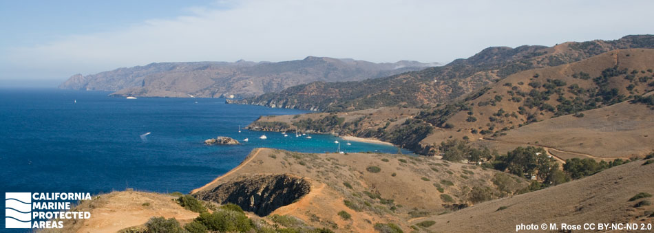
Arrow Point to Lion Head Point State Marine Conservation Area (SMCA) is located northwest of the town of Two Harbors along the northeastern side of Santa Catalina Island. The SMCA covers a narrow band of nearshore marine habitat nearly three miles long, the greatest length of protected shoreline on the island.

This marine protected area (MPA) covers a little more than half a square mile to depths of around 250 feet, and features sandy beaches, rocky shores, sandy and rocky seafloor, surfgrass beds, and kelp forests. Bays and coves dot the coastline, providing mooring and anchorage sites for boaters. Within the MPA, recreational anglers and spear fishermen can fish in accordance with current regulations, however no invertebrates, including lobster, abalone, crabs, and rock scallops, may be taken.

The habitats and associated wildlife in this MPA are quite diverse. Sheep crab scuttle along the sandy seafloor, while large spiny lobster and octopi can be spotted amongst the rocky reefs. Kelp bass and señoritas move through kelp, while pipefish swim through the surfgrass beds lining the ocean floor.

Regulations

It is unlawful to injure, damage, take, or possess any living, geological, or cultural marine resource, EXCEPT:

Recreational take of marine plants and finfish is allowed. Recreational take of invertebrates is prohibited. All commercial take is allowed in accordance with current regulations.

California Code of Regulations Title 14, Section 632(b)(123)(opens in new tab)

Quick Facts

MPA size: 0.65 square miles

Shoreline span: 2.9 miles

Depth range: 0 to 259 feet

Habitat composition*:

  • Rock: 0.22 square miles
  • Sand/mud: 0.55 square miles

*Habitat calculations are based on 3-dimensional area and may exceed the total MPA area listed above.

Photo Gallery

20 JUL
2022

Sea cauliflower at Arrow Pt to Lion Head Pt SMCA

0

photo © C. Cameron, CC BY-NC 2.0

Showing 0 Comment

Video Gallery

Southern California Marine Protected Area Highlights

California's MPA Network

About Arrow Point to Lion Head Point State Marine Conservation Area

Natural History

moray eel, abalone, urchin
Green abalone, moray eel, and red sea urchin at Arrow Point to Lion Head Point SMCA. photo © Stefanie, CC BY-NC 2.0

The narrow stretch of coast within the SMCA protects nearshore tidepools, rocky shores, beaches, and hidden bays. Small coves and sandy beaches, such as Sullivan's Beach and the aptly named Sandy Beach in Emerald Bay, feature the occasional rocks and jagged boulders. The sandy seafloor is inhabited by clams, orange phoronid worms, California halibut, and bat rays. Farther offshore, sand transitions to eelgrass beds where pipefish swim amongst the long, swaying shoots. Clusters of rocks and boulders create reef habitat with nooks, ledges, and crevices that make great hiding places for invertebrates. Common invertebrates include octopi, lobsters, abalone, and urchins. Aggregations of blue-banded gobies, garibaldi, and colorful gorgonian sea fans add vibrancy to the reefs. Schools of jack mackerel and anchovies circle the rocky submerged outcroppings, which transition to kelp forests.

Indian Rock, a small islet formed by rocky reefs, is located within the SMCA in Emerald Bay. In addition to being a famous dive site, Indian Rock serves as a sanctuary for seabirds. Brown pelicans and Brandt's cormorants can be spotted taking flight from Indian Rock, while birds such as western grebes nest on the pinnacle.

Cultural History

green abalone, blue-banded goby
Green abalone and blue-banded goby at Arrow Point to Lion Head Point SMCA. photo © emshaph, CC BY-NC 2.0

Native American Tribes in California have relied on marine and coastal resources for centuries. Many Native American Tribes in California continue to regularly harvest marine resources within their ancestral territories and maintain relationships with the coast for ongoing customary uses. Originally inhabited by Native Americans known as the Tongva, Santa Catalina Island, also known as Pimugna or Pimu by these first peoples, provided abundant resources for permanent villages for thousands of years. Ancient tools hand-fashioned from stone, shell, and bone, and piles of abalone shells have been found lying outside of caves.

Captain Juan Rodríguez Cabrillo was likely the first European explorer to visit the island in 1542. In November 1602, Philip III of Spain sent an expedition under command of Sebastian Vizcaino to map the California coastline. He anchored in what is now the crescent shaped harbor of Avalon on Saint Catherine’s Day and renamed the small sunny island “Santa Catarina'' or “Cathalina”.

Several coves in Arrow Point to Lion Head Point SMCA have an interesting history of varied ownership. In the mid-1800s, Howlands Landing was a sheep ranch; it is now home to an environmental leadership camp. Just southeast of Howlands Landing lies Big Geiger Cove, home of the Blue Water Cruising Club, a boating group founded in 1945 that has leased the shore facilities at the cove since 1953. John and Charles Johnson used nearby Emerald Bay for cattle grazing, hence the early name for the bay: Johnson's Landing. In 1925, a Boy Scouts of America facility was established at Emerald Bay. The facility has served as a Boy Scout camp since its founding, except for a short stint from 1940 to 1946 when the Navy requisitioned the camp for underwater demolition training.

In 1885, the island was sold for $200,000 to George R. Shatto, who sold land parcels to buyers from all over the country. In 1919, the island again changed hands and was sold for $3 million to the multi-millionaire chewing gum mogul and owner of the Chicago Cubs baseball team, William Wrigley Jr., who set out to make it a tourist destination. In the 1970s, Wrigley deeded 88 percent of the island to the Catalina Island Conservancy, and today much of it remains undeveloped and wild. Santa Catalina Island’s rich history can be seen in many of the historic landmarks that dot the landscape.

Recreation

kayakers near hilly shoreline
Kayakers at Emerald Bay, Arrow Point to Lion Head Point SMCA. photo © Peter & Joyce Grace, CC BY 2.0

Arrow Point to Lion Head Point SMCA is rich with recreational opportunities. Howlands Landing Road runs near the shoreline of much of the southeastern end of the SMCA, providing easy access from shore. At the southern end, a picnic area and restrooms are available at Lion Head Point. Although no camping is available, campsites can be found around the corner from Arrow Point at Parson's Landing.

The various protected coves and bays within the SMCA boast world-renowned snorkeling and diving. Indian Rock, just offshore at Emerald Bay, is a frequent stop for scuba diving tours. For the boating community, there are several mooring and anchorage sites that are managed by Catalina Island Company and can be reserved through their website. With the exception of invertebrates, all recreational take is allowed in accordance with current regulations in Arrow Point to Lion Head Point SMCA.

Coordinates

This area is bounded by the mean high tide line to a distance of 1,000 feet seaward of the mean lower low tide line of any shoreline southeastward of a line connecting the following two points:

33° 28.652′ N. lat. 118° 32.310′ W. long.; and
33° 28.820′ N. lat. 118° 32.310′ W. long.
and northwestward of a line connecting the following two points:
33° 27.240′ N. lat. 118° 29.900′ W. long.; and
33° 27.174′ N. lat. 118° 30.089′ W. long.

California Code of Regulations Title 14, Section 632(b)(123)

Downloads for Arrow Point to Lion Head Point State Marine Conservation Area

Map

Map of Arrow Point to Lion Head Point SMCA - click to enlarge in new tab

Facts, Map & Regulations

MPA fact sheet - click to enlarge in new tab